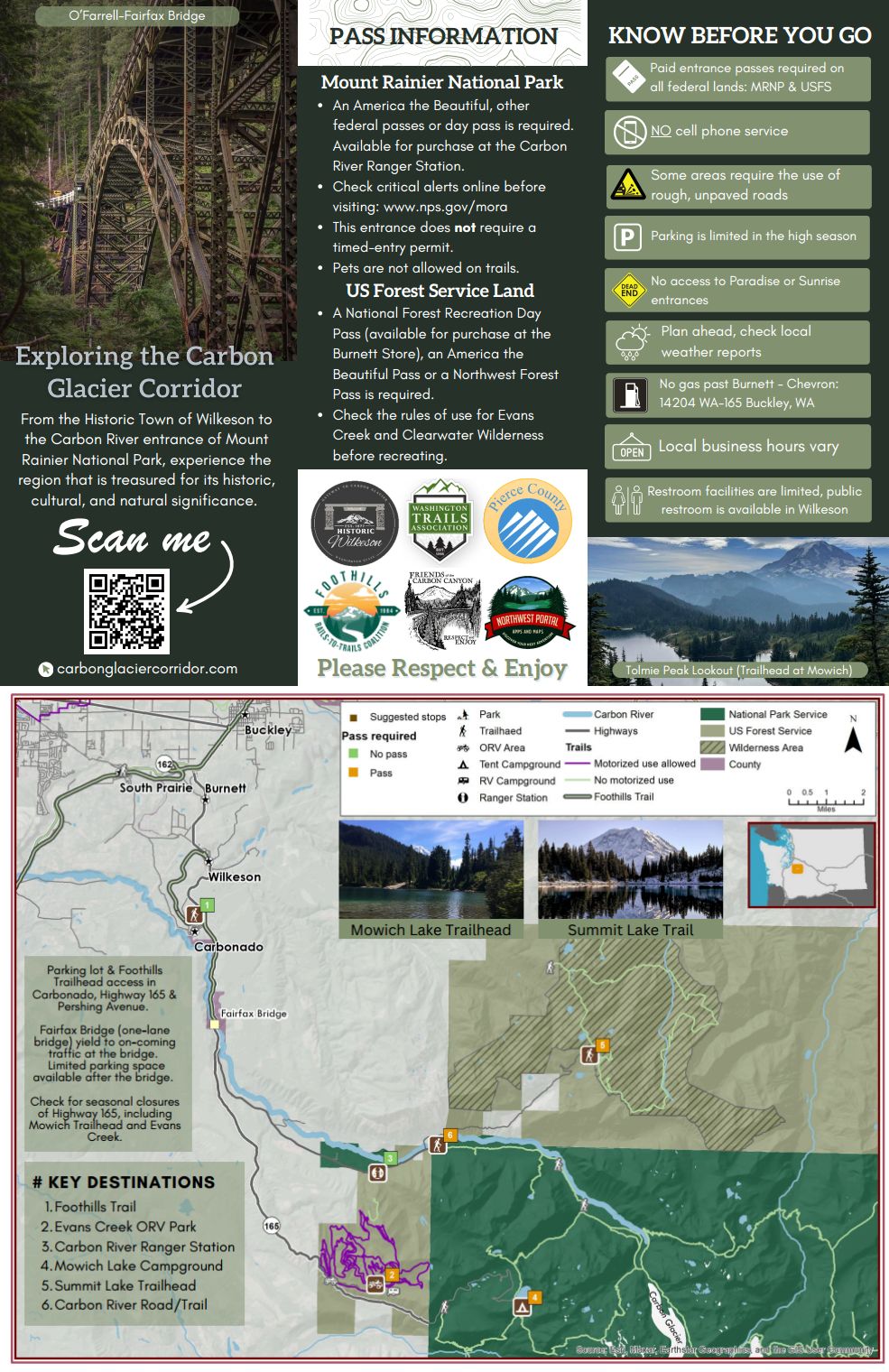
New local map makes the Carbon River corner of Rainier easier to explore
On the northwest corner of Mount Rainier National Park is a series of communities and outdoor experiences that make an ideal getaway for visiting the park, even when you don’t have reservations. The town of Wilkeson has collaborated with partners, including WTA, to create a locally-designed visitor access map to guide your visit.
On the northwest corner of Mount Rainier National Park is a series of communities and outdoor experiences that make an ideal getaway for visiting the park, even when you don’t have reservations. The Carbon Glacier Corridor offers unexpected views of Mount Rainier, both within and outside of the official national park entrance. There is much to explore in the area, whether or not you’re looking to peek at Tahoma. To reach this area, you will drive through the town of Wilkeson. To help visitors, the town has collaborated with partners, including WTA, to create a locally-designed visitor access map to guide your visit.
 Summit Lake offers beautiful views of Mount Rainier from outside of the national park. Photo by trip reporter Hikin' Micah.
The Carbon Glacier Corridor offers a host of outdoor opportunities, including multi-use Forest Service lands and a quieter side of Mount Rainier National Park. When visiting this entrance to the national park, you can hike to the lowest-elevation glacier in the lower 48 states. What you won’t find? The robust visitor infrastructure that meets you at Paradise (reached via Highway 410 and Snoquera) or Sunrise. So it’s a good idea to go well-prepared.
Responsible stewards know that getting familiar with the area you’re visiting is the most respectful and safe way to enjoy a place. That’s why folks who live and work in the Carbon Glacier communities have come together to create a tailored map, a kind of local voice as part of your experience.
So what piques your interest? A forest-lined bike-ride down the Foothills Trail? Exploring the historic towns of Wilkeson, Carbonado and Buckley for stops like the soda shop, the Bacon and Eggs skatepark or the museum? Looking for the Evans Creek Campground? Get your bearings in the area using the map below.

You can find the map digitally (and to download for offline use) at CarbonGlacierCorridor.com. The website also lists the most up-to-date information on business hours in Wilkeson, day-trip itineraries and trail recommendations.
If you’re planning to visit the Carbon entrance of Mount Rainier National Park, make sure to check for alerts from the park and check WTA trip reports. If you plan to visit the Mowich Lake Trailhead, check to see if the Mowich Road is open (typically mid-July). You will need an entrance pass to visit national park lands, but timed entry reservations are not necessary for this park entrance. You can always visit the Mount Rainier Carbon River Ranger Station to get a more detailed park map and information.
Respect and enjoy!


Comments