 Washington Trails
Association
Trails for everyone, forever
One hiker’s quest to see it all, and how WTA helped her get there. | By Catherine Vine
I took a step and my leg sunk calf-deep in mud. I swatted away a few mosquitoes, sighed and kept going. I was 10 miles into an 18-mile day and I was hot, tired and admittedly a bit cranky. I was also 2 hours delayed in meeting my friend, who was patiently waiting for me to arrive so we could finish the trek to Longmire together. Many hours later, after surviving a terrifying river crossing and running from a swarm of angry bees, we were back at our cars and ready to head home in the dark.
Some days are tougher than others, but I’ve never had a truly bad day at Mount Rainier National Park. Along with the tired legs and blisters come dainty alpine flowers, quiet moments of reflection in dense forests, fleeting glimpses of wrens and heart-stopping views.
This year, I set a goal of completing all the maintained hikes within the park’s boundaries. This quest has taken me to the far-flung reaches of the park — from the quiet Huckleberry Creek trail in the northeast to the seldom-visited stretch of trail where the park boundary meets the Glacier View Wilderness on the west side, and everywhere in between.

Catherine and her friends Shannon and Joanna on an early season snowshoe trip to Myrtle Falls at Mount Rainier.
Like many, I became enamored with both the mountain itself and the vast wilderness surrounding it when I moved to Washington 5 years ago from the East Coast. I couldn’t believe that my weekends could be spent exploring such an incredible place. Since I was a new and inexperienced hiker, I sought out information that would help me be both safe and respectful to the land and fellow hikers. I discovered the vast array of free resources available on the Washington Trails Association’s website, wta.org. I read trip reports, used the online Hiking Guide to select trails and read everything in the Trail Smarts section.
I took my first trip to the mountain that summer with my partner, exploring a short distance along the Sourdough Ridge Trail at Sunrise. I was hooked! I came back a few weeks later, this time solo, and suffered through the climb to the top of the Skyline Trail at Paradise, urging my flatlander legs to take just a few more steps. I panicked when I heard what I thought was a fellow hiker blowing a whistle for help, only to be reassured by passing hikers that it was just a marmot calling. I stumbled on the steep rocky steps, had to sit down a number of times to catch my breath and came home with an epic sunburn, yet I was still eager for my next visit.

Catherine hiked all of the trail highlighted in yellow in Mount Rainier National Park.
This is the power of the mountain and the reason over 2.5 million people visited the park in 2023 alone. Since time immemorial, people have been drawn to the area for the resources it provides, the recreation opportunities available and its overall splendor. The park is celebrating its 125th anniversary this year, and it seemed like a perfect time to spend a year exploring all that it has to offer.
At the start of the year, I had hiked about 92 miles of the over 260 miles of maintained trail within the park’s boundaries. Completing them all before the end of the year was an ambitious goal, but one I knew I could complete with good weather, the help of friends and, most importantly, the resources that WTA could provide.
I started planning my project in early spring. By then, I’d already taken several trips to the mountain to snowshoe the trails around Paradise. I knew that many of the upper-elevation trails would be inaccessible or snow-covered for months so I started researching which trails might be manageable come May and June. I turned to WTA’s website to see which trails typically had trip reports from the early spring, using the filter feature to narrow the region to Mount Rainier and search by month hiked. I read trip reports going back the last few years, forming a plan of which trails I might be able to tackle first. I created a spreadsheet, listed out all the hikes I needed and scheduled each week.
No problem!

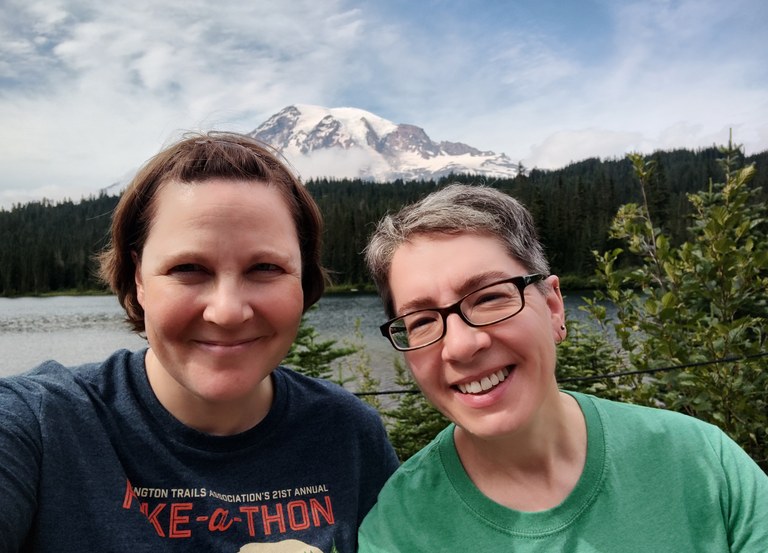
Catherine and her partner, Tracy, pause for a photo at Reflection Lake on a family visit to the park this summer.
Of course, as typically happens, life had other plans. A less-than-average snowpack decided to linger, keeping many trails off-limits later than normal. A round of illness in early July knocked out 2 days of hiking. I failed to secure a spot in the early-access lottery to book backcountry camping reservations. I navigated the complexities of entering the park with the new timed entry reservation trial. I edited my spreadsheet over and over, adjusting to each new challenge.
I don’t know if I’ll be able to finish hiking every mile of trail in Mount Rainier National Park this year, and I’m honestly not sure it matters anymore.
My main goal in attempting this project was to spend as much time as possible at the mountain, exploring all over the park. I’ve had the chance to hike so many new trails, and I did my first overnight trips to the park, along with my first solo backpacking trips. I was able to join a friend for her first hike with her 2-month-old daughter at Ohanapecosh and spend time exploring Tipsoo Lake with visiting family. I got to watch the faces of park guests light up when they first saw the mountain or spotted a marmot sunning on a rock. I’ve had some grueling, long days on trail with good friends, testing our limits and supporting each other through the hardest parts. I’ve sat quietly with a friend and six strangers around Aurora Lake while camping at Klapatche Park, watching the sun go down over the mountain. I spent many days hiking solo, enjoying the opportunity to just be present and quiet. I’ve met so many wonderful people on trail, from families with young kids enjoying a day outside to Wonderland Trail thru-hikers on their long trek around the mountain.

Catherine picking up her first backpacking permit at Mount Rainier National Park.
This, to me, is the best thing about spending time in the park. There is no right or wrong way to do it, whether you drive through the park to take in the incredible scenery, spend a day exploring the trails or stay longer for a backpacking trip. I encourage you to use resources such as WTA’s online Hiking Guide and park maps to find new areas to explore. Some of my favorite moments this year happened on less-traveled trails, like watching deer appear out of the mist on a rainy day on the Deadhorse Trail at Paradise or spotting an American dipper taking food to a nest of chicks inches from the pounding waters of Ohanapecosh Falls along the Eastside Trail.
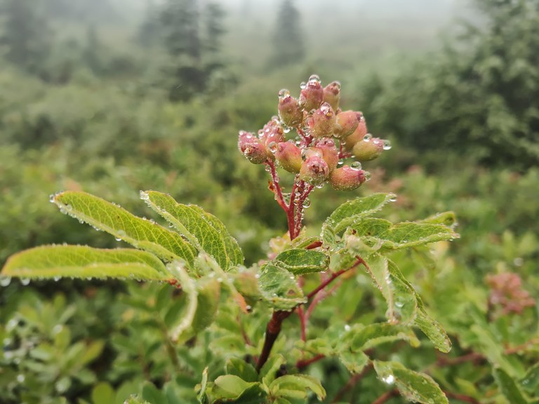
There are hidden gems all over the park if you take just a moment to find and appreciate them. Come for the stunning views, but stay for the beads of rain adorning mountain ash berries in the fall or a perfect, delicate calypso orchid tucked in among the rocks on the mossy forest floor in the early spring. Whatever you’re seeking — solitude or companionship, a long alpine climb or a quiet forest ramble — you can find it here at Mount Rainier National Park, and WTA can help.

Mount Rainier trails can be explored all year long. Photo by Catherine Vine.
Adventure safely in the winter — visit wta.org/winter for tips and learn about avalanche safety at nwac.us. And check the weather and road status before heading out. All visitors to the park are required to carry tire chains from November through April, regardless of weather, and rangers will check for chains at various locations.
Conditions can change quickly, especially in the winter and spring. Stop by the Longmire Museum, the Henry M Jackson Memorial Visitor Center at Paradise or the Carbon River Ranger Station before starting your adventure to pick up a winter trail map and get up-to-date trail and avalanche conditions. Staff can also recommend trails that best suite your interest and experience. Check the park's website for operating hours.
Seasonal road closures provide a chance to explore sections of the park normally inaccessible to hikers.
Catherine Vine followed her passion for hiking to a job with WTA’s development team. In the summer, she volunteers as a Meadow Rover at Mount Rainier and loves meeting park guests.