
The Northern Loop is a lovely, shorter alternative to the Wonderland Trail. Not quite as strenuous as the Wonderland, the Northern Loop spends a fair amount of time out of sight of the mountain. As a result, the hiking experience is much different than that of many other trails here. It's best tackled as a 4- to 5-day backpacking trip, but you can take as little or as much time as you want.
It's best to start at Sunrise, since you'll need to get permits from the ranger station at White River in advance of beginning this hike. And since it's a loop, you can do it clockwise or counterclockwise. This entry describes a clockwise route.
Start at Sunrise, and head out on the Sourdough Ridge trail toward Frozen Lake and Fremont Lookout. At a three-way junction for Burroughs, Fremont Lookout, and the Wonderland Trail, stick to the Wonderland and head west, away from the day hikers heading to Burroughs and the lookout.
Traverse toward Skyscraper Pass and Peak. The pass is at 4 miles from the trailhead. Standing in it, you'll see a striking difference between the moonscape of the area around Sunrise with the much more lush slopes on the west side of the pass.
Switchbacking downhill now, you'll pass by Granite Creek Camp and then to a crossing of Winthrop Creek. Climb again up onto a shoulder and then south through increasingly dense forest towards the mountain to another crossing of the West Fork of the White River. 5.2 miles from Skyscraper Pass, arrive at Mystic Lake and camp.
Mystic Lake is also home to a ranger station. Chat with them if they're on duty, or simply rest up in camp before pressing on. The trail winds around the lake to the south and follows Moraine Creek downhill through Moraine Park all the way through Dick Creek Camp to a bridge over the Carbon River, 3.4 miles from Mystic Lake. This section is gorgeously forested and gently graded until the last section through Dick Creek Camp, which can be a little challenging with a full pack. Take your time.
Here, you may start to see a number of day hikers. You're close to the Carbon River entrance of the park here, and plenty of people access the park in this area, including Wonderland Trail hikers. You'll continue one more mile on the Wonderland trail, passing a junction where the Wonderland heads left. You'll continue straight, and soon follow the trail in a tight switchback, the first of many that will take you 3,075 feet up in 3.45 miles to a junction with a way trail towards Tyee Peak.
Along the way, you'll climb up out of the temperate forests of the Carbon River valley into the open high country and pass under Yellowstone Cliffs. These striking cliffs are worth a stop to admire them (and, let's be honest, to catch your breath after all that climbing).
Past the junction for the way trail to Tyee is one of my favorite stretches of this loop. You're walking through wide-open meadows with gorgeous views of the peaks that sit in front of Rainier: Crescent Mountain, Old Desolate and Sliuskin.
Soon, though, the trail begins to drop. This is the start of a 1.6-mile descent back into the forested lowlands to Lake James (where there is a camp available). From Lake James, it's 2.1 miles to the crossing of the West Fork of the White River.
This crossing can be dicey. Bridges wash out frequently, leaving backpackers little good infrastructure to rely on to get across. Use caution, and try crossing as early in the day as possible to take advantage of lower water. It's also a good idea to try this hike later in the season, so the spring melt has subsided a bit.
Across the river, put your shoes back on and embark on a 2-mile climb up to Fire Creek Camp. While this camp is a good option to refill water, it's not a scenic as many of the other locations along the way. If you can get a permit to Berkeley Park, choose to stay there instead.
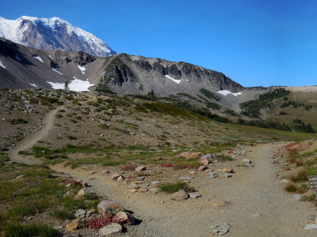
From Fire Creek Camp, continue climbing to a striking viewpoint of the mountain at 5600 feet — this is the first time you have seen it in all its glory for miles. Less than half a mile from the viewpoint is a junction for Grand Park. You'll stay right and continue hiking 2.1 miles to Berkeley Park.
At Berkeley Park, you may notice the number of people increasing. Many people make the trek to Berkeley Park for a day hike, or start their Northern Loop going counterclockwise by camping here. Amble through fields of wildflowers with the occasional marmot sighting before rejoining the Wonderland Trail at a junction you may find familiar — it was one of the first you passed through days ago when you started your trip. Turn left on the Wonderland and retrace your steps back to the Sunrise Visitor Center and the end of your hike.
 Trailhead