Trails for everyone, forever

Home Go Hiking Hiking Guide Nason Ridge Snowshoe

Nason Ridge Snowshoe

Central Cascades > Leavenworth Area
47.7955, -120.7160 Map & Directions
Length
3.6 miles, roundtrip
Elevation Gain
750 feet
Highest Point
3,200 feet
Calculated Difficulty About Calculated Difficulty
Moderate
View from Nason Ridge. Photo by Rob Shurtleff. Full-size image
  • Dogs allowed on leash
  • Good for kids
  • Mountain views

Parking Pass/Entry Fee

Sno-Parks Permit
Saved to My Backpack

A number of moderate snowshoe trails lie around the Lake Wenatchee area, but with a big, beautiful Ponderosa pine tree and views of the surrounding mountains, Nason Ridge gives you the best bang for your buck. Continue reading

Rating
3.00 out of 5

Hiking Nason Ridge Snowshoe

There are a number of nice, moderate distance snowshoe trails available around the Lake Wenatchee area, one at Lake Wenatchee State Park North and one at South, one at the Chiwawa See and Ski parking area and this snowshoe up the base of the Nason Ridge trail.

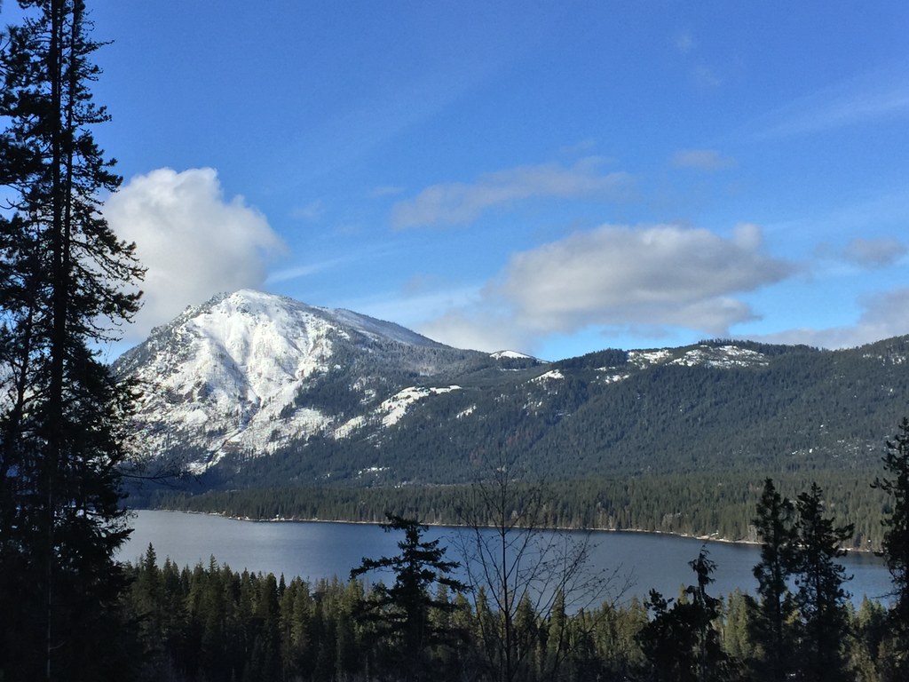
The route along Nason Ridge is the nicest, with excellent views over Lake Wenatchee, Fish Lake and across Lake Wenatchee to Dirty Face.

The first half-mile of this snowshoe is across the Kahler Glen Golf Course. As you drive into Kahler Glen, there will be a sign to the right to the summer trail head, ignore, go left to the golf course for winter parking (groomed Sno-Park permit required). 

From the parking area, cross the street to the golf course, where there where your route snowshoe starts (elevation 1,950 feet). 

Small blue signs will mark a snowshoe access trail found directly across the street from the entrance to the parking area. This trail heads west, adjacent to the hanging net of the gold course driving range. Please stay off the groomed trail, as snowshoes can pack down the snow irregularly for skiers. You are heading for the cement water storage tank at the base of Nason Ridge, where you might see an informal sled run below the water tank.

Once you reach the water tank, there is a trail marked with blue tape and trail markers heading up Nason Ridge.

The Nason Ridge trail climbs modestly up the north side of the ridge. Within a half mile, views open to the north on the right. Look down on Emerald Island, the pretty, small forested island that is off the beach at Lake Wenatchee State Park.

For most of the hike the forest was has been selectively thinned, which enhances the light and the views. You will cross a number of small seasonal creeks, all easily negotiated. As you proceed, Dirty Face towers above the north shore of Lake Wenatchee. You can also see frozen Fish Lake to the northeast, while Chiwawa Valley heads north. Farther to the east lie the Entiat Mountains.

At 1.8 miles from the parking lot, you will come upon “Big Red,” a spectacular Ponderosa pine. This is the first turning point. Continue past Big Red for an additional mile to visit the Nason Ridge warming hut at elevation 3,200 feet. The hut is at the intersection of the snowshoe trail and the groomed XC trails, and has a wood stove.

A second option has been added to the trail: 50 feet beyond Big Red, a trail goes up and to the left. This trail connects over to an abandoned logging road that gently climbs up the ridge for a mile. There is a good view point at the top. This also climbs up to 3,200 feet. 

WTA Pro Tip
: For the adventurous, pack your cross country skis, and you can ski back to your car, approximately 9 miles from this junction.

Toilet Information

  • Toilet at trailhead

More information about toilets

Hike Description Written by
Rob Shurtleff, WTA Correspondent

Nason Ridge Snowshoe

Map & Directions

Trailhead
Co-ordinates: 47.7955, -120.7160 Open in Google Maps

Before You Go

See weather forecast

Parking Pass/Entry Fee

Sno-Parks Permit

WTA Pro Tip: Save a copy of our directions before you leave! App-based driving directions aren't always accurate and data connections may be unreliable as you drive to the trailhead.

Getting There

Proceed to the junction of Hwy 207, the Lake Wenatchee Highway, and Highway 2 at Coles Corner (20 miles east of Stevens Pass, 15 miles west of Leavenworth). Turn north on 207.

Eight miles before the bridge over the Wenatchee River, turn left onto Cedar Brae Road. This is also the turnoff for Lake Wenatchee State Park. Cross the bridge over Nason Creek. In 0.2 miles turn left. You are continuing on Cedar Brae Road. If you continue straight you go to Lake Wenatchee State Park, there is a kiosk in the state park where you can purchase a daily Groomed Sno-Park permit, required for parking.

Continue 0.2 miles on Cedar Brae and then turn left into Kahler Glen Rd. Here, you'll see a sign for the Nason Ridge Trailhead pointing to the right. Don't go right; it leads to the summer parking lot and is not open in winter. Make a left at the fork, and continue 0.6 miles to the winter parking area on your left, directly across from the Golf Course barn and driving range, just before the Honeycomb Lodge Restaurant.

Note that a daily Sno-Park permit and Discover Pass OR seasonal groomed Sno-Park Permit is required in this parking area.

More Hike Details

Trailhead

Central Cascades > Leavenworth Area

Nason Ridge (#1583)

Okanogan-Wenatchee National Forest, Wenatchee River Ranger District

You can improve or add to this guidebook entry!

Nason Ridge Snowshoe

33 Trip Reports

Hiked here recently?

Submit a trip report!
 
Loading trip reports...
Trip Reports