From the signboard, set out westbound on a course parallel to the highway, entering young Douglas-fir forest. The path is a bit rutted near the start, but smooths out farther along. Undergrowth is primarily vanilla leaf. At a quarter mile, the young Douglas-fir forest transitions to a more mature Ponderosa pine forest.
Then at 0.4 mile, the trail begins switchbacking up the face of the hill on your right. Douglas-fir and pine share the terrain, providing shade for the hiker. Undergrowth becomes more sparse. Water bars for diverting runoff from the trail are made of a flexible material, to be more accommodating to the two-wheeled vehicles that use this trail.
At 1.3 miles, reach a ridgetop, featuring interesting rock formations. Continuing on, the trail once again climbs steeply, for a scant half mile, to the marked junction with Trail #952, the West Quartz Creek Trail, at 1.8 miles. The West Quartz Creek Trail forms a loop 11 miles long. From the junction, to the right 250 feet is a forest service road. Just across the road, trail #952 continues to the north.
For views, go left from the junction, heading southwest on trail #952, climbing modestly along Fifes Ridge. At 0.4 mile from the junction, views of the valley below begin to appear on your left. You can see the rock formations you passed by earlier.
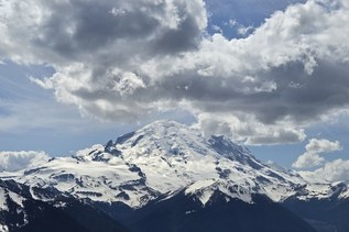
At 1 mile from the junction, there is a clearing, with trailside unobstructed views of Mount Rainier and more (on a clear day).
Turning around here and retracing your steps makes for a round trip of 5.4 miles.
WTA Pro Tip: There is no water along this trail, so bring and carry what you will need.
 Trailhead