Trails for everyone, forever

Home Go Hiking Hiking Guide Hand Shake Trail

Hand Shake Trail

South Cascades > Mount Adams Area
46.0786, -121.7598 Map & Directions
Length
0.01 miles, roundtrip
Elevation Gain
0 feet
Highest Point
4,200 feet
Calculated Difficulty About Calculated Difficulty
Easy
The plaque commemorating the Handshake agreement. Photo by Susan Saul. Full-size image
  • Dogs allowed on leash
  • Fall foliage
  • Good for kids
  • Mountain views

Parking Pass/Entry Fee

None
Saved to My Backpack

This short, accessible trail leads to a monument honoring the Hand Shake Agreement of 1932 that reserved a portion of the Sawtooth Berry Fields for use by Native Americans. Continue reading

Rating
0.00 out of 5

(0 votes) Log in to rate

Hiking Hand Shake Trail

This short, accessible trail leads to a monument honoring the Hand Shake Agreement between the Forest Service and the Yakama Nation.

For generations, the Yakama people have gone to this area in late summer to gather huckleberries to can and dry for winter food. They claimed that their rights to gather roots and berries in this area were reserved for all time in the treaty of 1855.

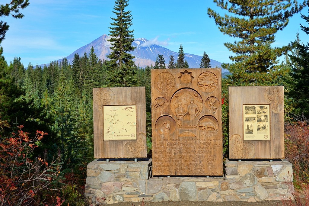
In 1932, Yakama Chief William Yallup and Columbia National Forest (now the Gifford Pinchot National Forest) Supervisor J.R. Bruckart used a Hand Shake Agreement to reserve an area of the Sawtooth Berry Fields northeast of the Indian Heaven Wilderness for exclusive use by Native Americans and also to reserve the four campgrounds in the huckleberry fields for their exclusive use.

The historical significance of this agreement is honored by the monument accessed by the Hand Shake Trail.

Toilet Information

  • No toilet at trailhead

More information about toilets

Wheelchair Accessibility

The entire trail is wheelchair accessible. A person using a wheelchair may need assistance on gravel.

Hike Description Written by
Susan Saul, WTA Correspondent

Hand Shake Trail

Map & Directions

Trailhead
Co-ordinates: 46.0786, -121.7598 Open in Google Maps

Before You Go

See weather forecast

Parking Pass/Entry Fee

None

WTA Pro Tip: Save a copy of our directions before you leave! App-based driving directions aren't always accurate and data connections may be unreliable as you drive to the trailhead.

Getting There

From Trout Lake, the distance is about 22 miles. From the Y intersection in Trout Lake, take SR 141 west for 1.6 miles. Turn right on paved FR 88. Drive for 15.8 miles. Continue straight onto FR 24. Go straight at the junction with FR 30 as the paved road turns to gravel. Drive about 1 mile on gravel, crossing the intersection with the Pacific Crest Trail in about 0.5 mile. Look for a large pullout on the left with the trail sign next to the pullout.

More Hike Details

Trailhead

South Cascades > Mount Adams Area

Hand shake (#67)

Gifford Pinchot National Forest, Mount Adams Ranger District

You can improve or add to this guidebook entry!

Hand Shake Trail

0 Trip Reports

Hiked here recently?

Submit a trip report!
 
There aren't any trip reports for this hike yet.
Loading trip reports...