Trails for everyone, forever

Home Go Hiking Hiking Guide Douglas Creek Canyon - South

Douglas Creek Canyon - South

Central Washington > Wenatchee
47.4614, -119.8726 Map & Directions
Length
4.0 miles of trails
Elevation Gain
250 feet
Highest Point
1,600 feet
The flowing Douglas Creek Falls. Photo by Chris Burke. Full-size image
  • Fall foliage
  • Good for kids
  • Waterfalls
  • Wildflowers/Meadows

Parking Pass/Entry Fee

None
Saved to My Backpack

Visit a popular water feature close to the trailhead, or get your feet wet and continue walking up the canyon along a rough road/railroad grade. Continue reading

Rating
3.00 out of 5

(5 votes) Log in to rate

Hiking Douglas Creek Canyon - South

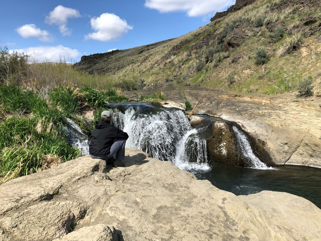
You can see many of this hike’s features from the parking area. To the north, an obvious railroad grade crosses Douglas Creek and heads up the canyon. The creek itself is pleasant, and the canyon is scenic. A couple of waterfalls add to the picture.

From the parking area, walk down a rough jeep road to reach the creek. Here you can poke around, upstream and down, enjoying the waterfalls. If you don’t think too hard about what’s in the agricultural runoff from the Waterville Plateau, you can take a dip and splash around in the waterfalls. Wildflowers and birds are abundant in season.

The walk to and from your car to the falls, with additional exploring in the area, come to barely a mile of hiking. For more, follow the road/railroad grade across the creek and up the canyon. If you are willing to get your feet wet, here and at a few more places along the road, you can walk another 3 miles to the Douglas Creek Canyon - North trailhead. The road stays on the canyon floor, sometimes on the old railroad grade, and passes numerous camping areas next to the creek. RVs sometimes park here, having arrived from the north.

When you climb back to your car, you might find yourself wondering where the trains used to go. The railroad grade appears to end in a steep ravine cut into a hillside. Here is the final feature of this hike: a collapsed railroad tunnel!  The rail line went through a short tunnel here, then continued down Moses Coulee on the way to the mainline at the Columbia River. Your car is parked practically on top of the collapsed tunnel! If you look around a bit near the parking area, you can spot a depression in the ground above where the tunnel caved in.

WTA Pro Tip: Looking for more mileage, but similar canyon vibes? Check out the Douglas Creek Canyon - North hike

Toilet Information

  • No toilet at trailhead

More information about toilets

Hike Description Written by
Chris Burke, WTA Correspondent

Douglas Creek Canyon - South

Map & Directions

Trailhead
Co-ordinates: 47.4614, -119.8726 Open in Google Maps

Before You Go

See weather forecast

Parking Pass/Entry Fee

None

WTA Pro Tip: Save a copy of our directions before you leave! App-based driving directions aren't always accurate and data connections may be unreliable as you drive to the trailhead.

Getting There

The drive to the trailhead is a bit of an adventure in itself. From SR 28 about 14 miles south of Wenatchee, turn onto Palisades Road and drive up Moses Coulee. About 14 miles up paved Palisades Road, turn left onto Wagon Road. Bear left at a Y and shortly turn left onto unpaved Douglas Creek Road. You will likely have to drive through unbridged Douglas Creek in about a quarter mile. The road then climbs steeply for about 1.5 miles and reaches a parking area on top of a ridge. There is a BLM signboard here.

More Hike Details

Trailhead

Central Washington > Wenatchee

Bureau of Land Management

Guidebooks & Maps

Best Desert Hikes: Washington (Bauer & Nelson - Mountaineers Books)

Washington State Department of Natural Resources (DNR) Moses Lake

BLM Duffy Creek and Douglas Creek recreation sites: https://www.blm.gov/visit/douglas-creek

You can improve or add to this guidebook entry!

Douglas Creek Canyon - South

26 Trip Reports

Hiked here recently?

Submit a trip report!
 
Loading trip reports...
Trip Reports