Trails for everyone, forever

Home Go Hiking Hiking Guide Copper Creek Hut Snowshoe

Copper Creek Hut Snowshoe

Mount Rainier Area > SW - Longmire/Paradise
46.7829, -122.0501 Map & Directions
Length
8.8 miles, roundtrip
Elevation Gain
1,040 feet
Highest Point
4,200 feet
Calculated Difficulty About Calculated Difficulty
Moderate

Copper Creek Hut and the North District trails are closed each year between mid-April and mid-Nov for wildlife protection. They are only open during the winter season.

The hut is a great stop for lunch on a sunny winter day. Photo by JazzyGoatRuff. Full-size image
  • Dogs not allowed
  • Good for kids
  • Mountain views
  • Wildlife

Parking Pass/Entry Fee

Sno-Parks Permit
Saved to My Backpack

Yes, there really is a hut on the Copper Creek Hut trail, and it’s open to the public! The Mount Tahoma Trails Association, a non-profit organization, operates over 50 miles of cross-country ski and snowshoe trails and a system of huts for day and overnight use near Ashford, just west of Mount Rainier National Park. Continue reading

Rating
3.75 out of 5

(4 votes) Log in to rate

Hiking Copper Creek Hut Snowshoe

Although primarily a cross-country ski trail network, snowshoers are welcome on the Mount Tahoma Trails Association trails and in the huts so long as trail etiquette is followed. This generally means keeping to the edges of the groomed trails and yielding right of way to skiers. As most of the trails do double duty as logging roads in the summer, there is plenty of room for all to enjoy the gently rolling terrain come winter.

Follow the signs to Forest Road 92, which leads to "North District" sno-parks and the trailhead to Copper Creek. The distance to the hut depends, as there are sno-parks that serve as parking areas, depending on snow conditions at various altitudes. The lower the snow line, the longer the distance to the hut. Plan on a minimum of a 9-mile roundtrip hike, and note that Washington non-motorized Sno-Park Permits are required at all the parking areas.

Along the way, the trail is well-signed and moderately inclined for about a mile, until you arrive at a junction marked "Cooper's Loop." No signs here indicate which way the hut is, so to reach Copper Creek Hut, take the right fork. The left fork heads uphill, following a ridgeline and a series of snowshoe blazes back to the Overlook Trail and ultimately looping back to the upper Sno-Park.

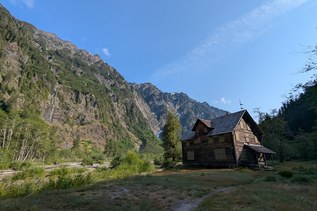
On the right-hand trail heading towards the hut, gradually gain elevation until reaching another junction, about 3 miles from the upper parking area. Here you can either take the Rainier View Trail or the Valley View Trail to reach the hut; the trees have grown enough that neither route affords a view of the mountain, but the Rainier View Trail is more direct. Take it, and after another mile, arrive at a final junction, where the hut is only half a mile away. The trail descends from here, then traverses around a knob and ascends steeply for just a few hundred feet, ending directly outside Copper Creek Hut.

WTA Pro Tip: Navigating snow travel can be difficult and dangerous! Be prepared by looking at trip reports (below), reading about the hike on the Mount Tahoma Trails Association website and brushing up on our winter safety tips.

Seasonal closure

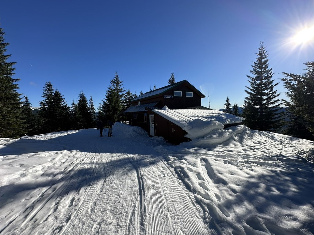
North District trails (from the 92 Road Sno-park along the Rainier Vista Trail to the 10th Mountain) and Copper Creek Hut are only open in the winter months (typically mid-November to mid-April). This land is owned by hte Nisqually Land Trust and Nisqually Community Forest. They are federally protected as a sensitive wildlife habitat and closed from spring to fall. Dogs are not allowed at any time. 

Reservations

Each of the huts are open and free to enter during the day, but from 7 p.m. to 7 a.m., guests must have advance online overnight reservations. Reservations for Copper Creek Hut can be made on the Mount Tahoma Trails Association website.

Hike Description Written by
Kirt Lenard, WTA Correspondent

Copper Creek Hut Snowshoe

Map & Directions

Trailhead
Co-ordinates: 46.7829, -122.0501 Open in Google Maps

Before You Go

Copper Creek Hut and the North District trails are closed each year between mid-April and mid-Nov for wildlife protection. They are only open during the winter season.

Reservations must be made to stay overnight in the Copper Creek Hut. See the hike description for more details.

See weather forecast

Parking Pass/Entry Fee

Sno-Parks Permit

WTA Pro Tip: Save a copy of our directions before you leave! App-based driving directions aren't always accurate and data connections may be unreliable as you drive to the trailhead.

Getting There

The Mount Tahoma Trails System is located near Ashford, just outside the west entrance to Mount Rainier National Park. From I-5 near Tacoma, take Highway 7 south to its junction with Highway 706 in Elbe. Turn left, toward Ashford and the National Park. The access road, Forest Road 92 (278th Ave E), is located at mile marker 6 (1 mile) just west of the town of Ashford. Watch for the sign on the left.

After about a mile, the 92 road reverts to a typical logging road. Volunteers plow the road to the usable sno-park closest to the trailhead, but conditions can turn snowy and icy and all vehicles should have tire chains ready for use. On weekends, all first-time visitors are encouraged to stop in at the Mount Tahoma Trails Association Office, located behind the Fire Station in Ashford, for further information, maps and trail conditions.

Note: Sno-park permits, not Discover Passes, are required between November and April. 


Copper Creek Hut can be found at these coordinates: 46.77655, -121.99661

More Hike Details

Trailhead

Mount Rainier Area > SW - Longmire/Paradise

Washington State Department of Natural Resources

Guidebooks & Maps

100 Cross Country Ski Routes in the South Cascades by Spring/Kirkendall

USGS Mount Wow

Mount Tahoma Trails Association Map (at Whittaker Mountaineering in Ashford) or here: https://skimtta.org/maps-and-directions/

You can improve or add to this guidebook entry!

Copper Creek Hut Snowshoe

124 Trip Reports

Hiked here recently?

Submit a trip report!
 
Loading trip reports...
Trip Reports