Trails for everyone, forever

Home Go Hiking Hiking Guide Bullion Basin

Bullion Basin

Mount Rainier Area > Chinook Pass - Hwy 410
46.9378, -121.4746 Map & Directions
Length
5.8 miles, roundtrip
Elevation Gain
2,200 feet
Highest Point
6,300 feet
Calculated Difficulty About Calculated Difficulty
Moderate/Hard
A summer view along the Bullion Basin trail. Photo by Erik Morgenstern. Full-size image
  • Established campsites
  • Fall foliage
  • Mountain views
  • Wildflowers/Meadows

Parking Pass/Entry Fee

Northwest Forest Pass
Saved to My Backpack

A relatively steep and rocky connector trail running between the Crystal Mountain resort area up through Bullion Basin to the Pacific Crest Trail with mountain and meadow views. Continue reading

Rating
3.14 out of 5

(7 votes) Log in to rate

Hiking Bullion Basin

The Bullion Basin trail starts off Crystal Mountain's Upper Parking Lot C. Follow the path as it climbs into the woods. In 150 feet, ignore a cleared snow machine path and continue up the hill, marked the Blue Bell Loop snowshoe trail, to Gold Creek Road and turn right uphill. Come to another junction with a Crystal Mountain Trails kiosk, where a Forest Service sign (left of the kiosk) points up the overgrown trail uphill (Mary Lee snowshoe trail), or simply stay left on the road as it ascends past first switchback to trail crossing. Continue on the trail making your way north-northeast up the hillside, through a meadow with kiosk, and follow the trail as it shortly crosses a little bridge over Silver Creek. 

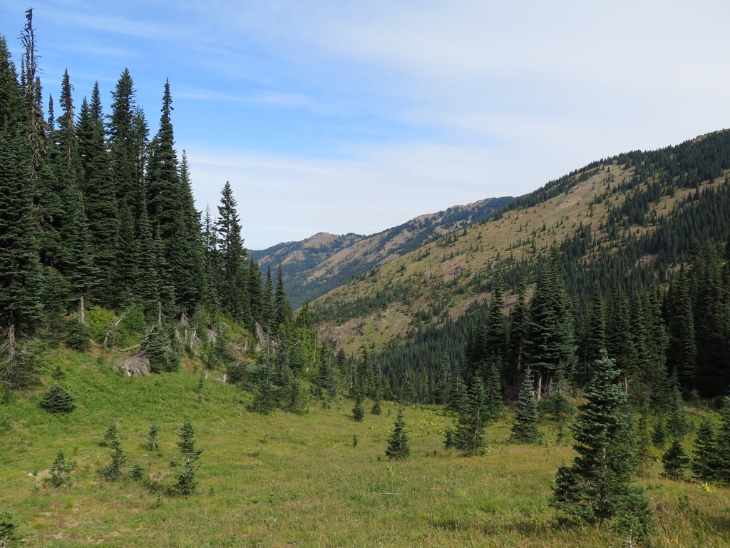
Continue long switchbacks up the ridge until the forest opens onto Bullion Basin. You may spot a shortcut trail running due east up to the Pacific Crest Trail from this point. Descend to the equestrian camp. Behind the first hitch rail on the right you will find a path to a nice wilderness toilet back in the woods, courtesy of an Eagle Scout project. 

Head south down past the horse camp and keep right directly after a creek crossing. Walk up through a narrow meadow again, keeping right where the trail splits, following the better-maintained trail path. Walk through one more, larger meadow and then climb the final switchbacks to the main viewpoint. Views of the White River drainage to the northwest, Rainier due west over the Crystal ski runs and Mount Adams to the south are all quite good. Continue past the viewpoint southeast and climb one final hill up to the main junction with the PCT. 

Extend your hike

For a longer, more strenuous, 7.7-mile loop, continue south on the Pacific Crest Trail past Crown Point, through Pickhandle Gap, past Pickhandle Point to Bear Gap where you can hang a tight right and drop down toward Henskin Lake and return to the Crystal Mountain resort area on the Silver Creek Trail.

WTA Pro Tip: Restrooms are available at the Crystal resort when open. The Crystal gift shop also offers some hiking supplies - handy if you forget your bug spray. Check the Crystal Mountain website for hours of operations, summer season dates and scheduled events that may bring larger crowds to the area. The nearest gas station is the Greenwater General Store 20 miles west on Highway 410.

Toilet Information

  • Backcountry privy available

More information about toilets

Hike Description Written by
Erik Morgenstern, WTA Correspondent

Bullion Basin

Map & Directions

Trailhead
Co-ordinates: 46.9378, -121.4746 Open in Google Maps

Before You Go

See weather forecast

Parking Pass/Entry Fee

Northwest Forest Pass

WTA Pro Tip: Save a copy of our directions before you leave! App-based driving directions aren't always accurate and data connections may be unreliable as you drive to the trailhead.

Getting There

From either eastbound or westbound Highway 410, 4.5 miles north of the turn to the Sunrise Visitor Center, turn east onto Crystal Mountain Blvd (NF 7166). Follow Crystal Mountain Blvd 6 more miles to the resort. Go left on Upper Parking Lot C and take an immediate hard right where you will find the trailhead, marked with a snowshoe map on the left and wood Forest Service sign on the right. 

Parking is available in the main Crystal Mountain resort lot when not in ski season. (You will need an Alpine Pass during ski season.)

There is road access from near the Norse Peak trail, but the gate on this road is often locked. Continue up to the Crystal Mountain parking area and head left into the parking near Silver Skis Chalet. Park here and look for the trail between the chalet and the main lodge area. 

More Hike Details

Trailhead

Mount Rainier Area > Chinook Pass - Hwy 410

Bullion Basin (#1156)

Mt. Baker-Snoqualmie National Forest, Snoqualmie Ranger District

Guidebooks & Maps

Green Trails Mount Rainier No 269sx

You can improve or add to this guidebook entry!

Bullion Basin

109 Trip Reports

Hiked here recently?

Submit a trip report!
 
Loading trip reports...
Trip Reports