

The Big Bend Wildlife Area is both complex and ultimately simple at the same time. This unit is compromised of more than 24,000 acres in a patchwork of landownership that straddles the southern border of the Columbia River northwest of Grand Coulee. Your friends, when being told that you are going to Big Bend, will surely think that you’ve got a trip to Texas planned. This area is so remote that you may believe that you’ve traveled to Texas by the time you get there. Do not let this discourage you, as those who make the effort are rewarded with largely pristine shrub-steppe terrain full of wildflowers, wildlife and incomparable views stretching from the snowy North Cascades to the Columbia River 1,000 feet below, and off into an infinity of dry coulees and scablands of Eastern Washington.
Much of this area of Washington was put under plow during the mid-twentieth century and most of that remains so. The area described here largely avoided the plow although there are a few homesteads, old access roads and even former ferry locations to visit and explore. A great history of the pre-colonial and early colonial uses of this land can be found in Ron Anglin’s book, Forgotten Trails.
There are multiple access points to the wildlife area. There is unfortunately no bathroom available. Locally, the primary access point is referred to as “Rock Lake.” Rock Lake is identifiable on maps, though the adjacent parking is not always depicted. Trust the directions and you’ll be fine.
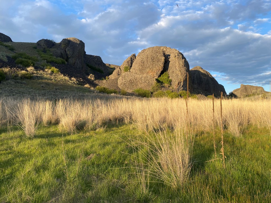
From the parking lot, a gated dirt road heads into Big Bend. Immediately, a large shallow basin opens up, bounded on the north by basalt lava flows. The eponymous rock (a haystack form the nearby cliffs) sits conspicuously in the middle of Rock Lake. Many birds migrate through and nest in this area making for fabulous birding. No trail exists around this lake, though a cross-country ramble is easily done connecting game trails and avoiding the wetter, marshy end to the west. At all times, there is complete visibility, so there is no chance of getting lost. A 1.5-mile walk loops this lake. Watch for badger dens, as they are big enough to quite nearly go knee-deep into.
If one stays on the old double-track road, keeping Rock Lake to your left, the road quickly and easily takes you through the crumbling basalt cliffs and deep into the shrub-steppe. This route description will entail less than 800 feet in elevation loss and then gain, though greater changes are available by climbing the hills or descending to the river.
Your double-track winds past small ponds, dry shrub-steppe hillsides, and past one or two abandoned homesteads. Stick to the main track and, at 3.75 miles from the parking lot, you will encounter an unmarked, lesser-used double-track to your left. Though very much unused, this old track is easy enough to follow as it winds through a moist seep. The harsh dryness quickly gives was to small wetlands, aspen groves and sultry greenery. Within a short mile, you will come to a remarkably expansive Black Lake, home to many shorebirds and surrounded by hillsides. By following the righthand edge of the lake, you will loop around the north end of the lake. This is a perfectly suitable place to turn around and retrace your steps, perhaps visiting or exploring some spots that you bypassed on the way in.
Should you choose to continue the loop, from the north end of the lake, continue on the double-track in a southwesterly direction. The track will climb ever so slightly; do not head uphill (unless of course you would like to and are comfortable making your own adventure). The double-track quickly gains the high point of the valley that you are in and begins descending into a more defined canyon. Note: Be sure to leave all gates as you find them. You will lose about 300 feet vertical feet in this cottonwood filled side canyon. Remnants of ranching exist here and there. Soon enough, you will pop out on China Creek Road. Take a left and walk uphill about 2 miles to Road 32 Rex, which turns due east. Two-plus miles on this road will take you right back to your car.
Though walking roads is probably not why you are out here, they really aren’t that bad. Huge views are to be had, and hitching a ride from a local rancher is usually pretty easy. They are great folks.
Remember, state land is public land and private land is to be respected. Leave all gates as you find them and pack out what you pack in. Springtime is the best time to hike here as the flowers are amazing. Summer is just too hot and autumn, though beautiful has the potential conflict of hunting season. Be aware that roads are generally impassable after rain until they’ve dried out.
 Trailhead


