Hike the State 2025: Four WTA staff share favorite summer hikes
Get excited for your next adventure with four WTA staffers as they reveal some of their favorite hikes from around the state. No matter your preferred type of trail, there's something here for everyone, as well as some great resources (and even food suggestions) to help you plan your next hike.
If you try any of these hikes, we'd love to hear about it in a trip report. If you can't make it out on trail right now, save them to your My Backpack account for later. By saving hikes to your backpack and writing trip reports, our hike recommender tool can help you find even more personalized hike suggestions.
If you find these WTA resources helpful, consider becoming a member and supporting our work. Thank you for investing in the future of trails.
Anna’s Hikes

Anna Roth (she/her)
In 2011, Anna came back to Washington after two years in Colorado and not enough coastline. She joined a WTA work party on National Public Lands Day in 2012, and less than a year later started at WTA. Now, she researches hikes and works with a team of correspondents who help her expand and improve WTA's hiking guide, and project manages WTA's app, Trailblazer. She’s happy to hike anywhere, whether it's a miles-long walk through her neighborhood or a multi-day backpacking trip, as long as the payoff is a view from a mountain top, ridge or pass.
Railroad Bridge Park
Location: Olympic Peninsula > Northern Coast
Length: 1.2 miles, roundtrip
Elevation gain: 67 feet

Photo by trip reporter ejain.
This delightful little park is part of the 135-mile Olympic Discovery Trail, which means you can hike as far as time allows, or as little as you like. You'll see salmon spawning in the fall, interpretive signs year round, even visit the Dungeness Interpretive Center before or after your hike. The area at Railroad Bridge is paved, so this section (and the section to the east) is wheelchair-friendly too!
> Plan your hike to Railroad Bridge Park using WTA’s Hiking Guide
Tongue Mountain
Location: South Cascades > Dark Divide
Length: 5.4 miles, roundtrip
Elevation gain: 1,502 feet

Photo by trip reporter Steve&Dee.
The Dark Divide is an incredible part of Washington where hikers, mountain bikers, horse riders and motorcycles can recreate with views of fascinating geological formations. Tongue Mountain rises from the valley floor on a rutted but clear trail to a gorgeous view from the summit. It’s a bit of a scramble to the true peak, but views are good even from the base of the peak.
> Plan your hike to Tongue Mountain using WTA’s Hiking Guide
White Bluffs North
Location: Central Washington > Tri-Cities Area
Length: 7 miles, roundtrip
Elevation gain: 500 feet
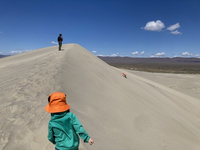
Photo by trip reporter Smooth Operator.
Sand dunes in interior Washington? Yes! The White Bluffs area near Hanford is a trek for folks on the west side but it’s a fabulous destination. The sand starts about two miles into the hike and there are a couple of dunes to explore, but the whole thing is just over 3 miles one-way with fairly low elevation gain, so it's kid- or beginner friendly. Want more? You can head south to explore more trails (albeit without the sand dunes) or use WTA’s Trailblazer app to find more hikes nearby.
> Plan your hike to White Bluffs - North using WTA’s Hiking Guide
Lyle Cherry Orchard
Location: Southwest Washington > Columbia River Gorge: WA
Length: 6.5 miles, roundtrip
Elevation Gain: 1,050 feet

Photo by John Rodriguez.
This gem of a hike on the Washington side of the Columbia River Gorge offers spectacular views of the Columbia River, amazing spring wildflowers and an old garry oak forest of gnarled old trees. WTA has worked here for years to help improve the trail system and give hikers the best views of this scenic area; it’s worth a stop!
> Plan your hike to Lyle Cherry Orchard using WTA’s Hiking Guide
Michael’s Hikes
 Michael DeCramer (he/him)
A lifelong Seattle Mariners fan, Michael loves the communities and landscapes of the Pacific Northwest. He believes that access to outdoor recreation enriches people’s lives. Time outside connects people to the natural world, other people and themselves. Michael is passionate about public policy and obsessed with trails. At WTA, Michael manages state and federal advocacy projects and works with elected leaders to deepen support for trails and public lands. Michael spends a lot of time daydreaming about his next thru-hiking adventure.
Annette Lake
Location: Snoqualmie Region > Snoqualmie Pass
Length: 7.5 miles, roundtrip
Elevation gain: 1,800 feet
Photo by trip reporter desal.
Come enjoy a well loved trail to a beautiful lake on the westside of Snoqualmie Pass. Much of the trail to Annette Lake is freshly restored thanks to federal funding from the Great American Outdoors Act. As you climb to the lake you will pass a large waterfall, walk through shaded forests and cross rocky talus slopes. The lake itself is well worth the elevation gain.
> Plan your hike to Annette Lake using WTA’s Hiking Guide
Oregon Butte
Location: Eastern Washington > Palouse and Blue Mountains
Length: 6 miles roundtrip
Elevation gain: 1,000 feet
Photo by Holly Weiler.
Panoramic views await you on this hike. Oregon Butte is the most prominent peak in the Blue Mountains. The view from the fire lookout at the top of this hike provides expansive views of the Wenaha-Tucannon Wilderness in Southeast Washington.
> Plan your hike to Oregon Butte using WTA’s Hiking Guide
Cutthroat Pass via the Pacific Crest Trail
Location: North Cascades > North Cascades Highway - Hwy 20
Length: 10 miles round trip
Elevation gain: 2,000 feet
Photo by trip reporter PNWdvm.
The Pacific Crest Trail is world renowned for its scenic beauty. There are many outstanding day hikes available along the PCT, but the trail to Cutthroat Pass is a true delight. The trail climbs above timberline and reveals craggy peaks and deep valleys stacked on top of each other. This hike delivers heaps of grandeur.
> Plan your hike to Cutthroat Pass via the Pacific Crest Trail using WTA’s Hiking Guide
Loren’s Hikes
 Loren Drummond (she/her)
Loren has dedicated her career at WTA and other nonprofits to using digital communications for creating change. She's backpacked (and rebuilt) sections of the Colorado Trail, and she's put in miles on the Appalachian and Pacific Crest Trails, too. At WTA, she loves connecting with and supporting an incredible community of volunteers, hikers and would-be hikers with Washington's wild places. She has a particular fondness for desert camping, alpine basins and marmots.
Evans Creek Preserve
Location: Puget Sound and Islands > Seattle-Tacoma Area
Length: 4.2 miles of trails
Elevation Gain: 325 feet

Photo of a common yellowthroat on on lupines by Tyler Hartje.
This trail system is a mini-magical landscape that transforms to meet your needs all year round and through many stages of a hiking life. In only a few miles of trail, it loops through several ecosystems spanning a one-time farm. WTA helped build the trails here, and they vary from steeper hillside climbs to easy rambles through wetlands and mini-wildflower meadows. It’s as perfect for a family picnic as it is for a serious trail runner trying to vary their terrain on endless loop options. As if that weren’t enough, it has ADA-rated trail options, and the upper trailhead is transit-accessible.
> Plan your hike to Evans Creek Preserve using WTA’s Hiking Guide
Clackamas Mountain
Location: Eastern Washington > Okanogan Highlands/Kettle River Range
Length: 8.8 miles, roundtrip
Elevation gain: 3,147 feet
 Photo by Loren Drummond.
On a lonely stretch of Hwy 20 between Republic and Tonasket, you’ll find this gem of a trail only 30 miles south of the Canadian border. It’s a remote trail, but right off a paved road (a rare combination) and an ideal trail to slot into early summer for a hiking or backpacking trip. It kicks off with a steep climb that rewards quickly with early views before winding through grassy meadows. Early summer rewards with wildflowers (and avoids the grazing cattle you might encounter later in the summer). This section of the Okanogan Highlands may not connect to as many miles as the nearby Kettle Crest, but it does have a rugged loop option and ties-in to the Pacific Northwest Trail.
> Plan your hike to Clackamas Mountain using WTA’s Hiking Guide
North Lake
Location: North Cascades > Methow/Sawtooth
Length: 10.6 miles, roundtrip
Elevation gain: 2,200 feet

Photo by trip reporter DaphneF.
This trail curls and climbs through a recovering wildfire burn around Gilbert Mountain up to a sweet alpine lake basin that sparkles in summer and shows off golden larches come fall. While the long road up Twisp River Road can make the trailhead feel like a long haul, it’s do-able as a dayhike or makes a worthwhile overnight, with a handful of established camps at the lake used by hikers and equestrians. For folks with the skills and appetite for more adventure, you can tack on a burly switchbacking climb up the unmaintained primitive trail to Abernathy Pass and peer (or hike) down into the Cedar Creek trail drainage.
> Plan your hike to North Lake using WTA’s Hiking Guide
Allie’s Hikes
 Allie Tripp (she/her)
Allie has worked at WTA since 2015, first on the fundraising team and more recently on the community engagement and impact team. Her perspective on hiking has changed in the last year as a new mom, where time in nature is even more needed and appreciated than ever before. You might see her on trails in the Teanaway or bird watching on the coast.
Iron Bear / Miller Peak
Location: Central Cascades - Blewett Pass
Length: 6.5 miles, roundtrip
Elevation gain: 1,800 feet
Photo by trip reporter Mercedes Benedict.
This hike has tons of payoff without a huge investment and it’s usually snow-free early in the season. Bring a guide along to help identify the many wildflowers you’ll spot along the way. You can access Iron Bear via one of two trailheads which have their tradeoffs (one has a bathroom, one has easier highway access). Looking for more of a challenge? Add on Miller Peak and make this a 13 mile loop with another ~2,000 feet of elevation gain. Just a heads up, this trail does open up to motorized use after June 15.
> Plan your hike to Iron Bear using WTA’s Hiking Guide
Striped Peak
Location: Olympic Peninsula - Northern Coast
Length: 7.5 miles, roundtrip
Elevation gain: 1,166 feet
Photo by trip reporter Chasing Dirt.
Views of the straight of Juan de Fuca and Vancouver Island and a beautiful trail built by WTA volunteers await hikers (and bikers and horseback riders) who are willing to make their way out on the Northern Olympic Coast, just past Port Angeles. The trail leaves from Clallam County’s Salt Creek Recreation Area, which has stupendous campsites, playgrounds and fields as well as leftover landmarks from WWII Camp Hayden. The hike itself pops in and out of the forests made up of cedar, fir and hemlock and even offers access to a rocky beach via the Cove Trail, though we recommend checking the tides before you go.
> Plan your hike to Striped Peak using WTA’s Hiking Guide
Your Questions, Answered
There were so many great questions during Hike the State 2025, and we didn't have time to answer all of them. Here are a few we heard from several folks, along with our answers and links to WTA resources:
With all the uncertainty about trail conditions and trailhead services this summer, how should I prepare differently?
With the crisis of staffing land managers are facing, you might see trails, bathrooms or roads that are less maintained than you’re used to. Also remember that emergency services may have longer response times, so it's important to hike well within your limits. This is a year to be extra prepared (pack the Ten Essentials, yes, all of them). You should have a backup plan in case the trail you want to hike is inaccessible or the parking lot is full.
You can also help by picking up trash you find on trail, and packing it all the way home with you. And remember that land managers are doing their absolute best to maintain trails and facilities while dealing with the challenges of reduced resources. Show respect and patience for the folks who work to protect our public lands, and help them out by being extra prepared on your visits.
How do I know what pass or permit is needed for a particular trail?
Each hiking guide entry indicates what pass is needed to park at the trailhead, or if necessary, to camp in the area. You'll find it just above the photo for the hike, next to the heading "Parking Pass/Entry Fee". These passes and permits are determined by who manages the land you will be hiking on. To understand more about what is needed for different trails, WTA's Passes and Permits page explains the ins and outs of permits, including seasonal changes, costs, and why permits exist.
This summer, you will be able to buy a pass at some Forest Service trailheads using Scan and Pay. Learn more about this system here.
How can I find groups of people to go hiking with?
WTA has a resource page with links to a plethora of hiking groups around the state.
How can I access trail information when I’m out of service?
Once you have a WTA account and you are logged into it on the Trailblazer app on your phone, you’ll automatically have offline access to all the hikes you have saved in My Backpack.
Mount Rainier, Lake Chelan & Mount Saint Helens:
There’s a lot going on at some iconic landscapes in Washington this summer. WTA has the download on the latest for a few places with some extra considerations. For more, sign up for our monthly email at wta.org/trailnews:
I want to hike with my dog. any tips?
Our top tips: Learn where dogs are allowed to hike with you, keep your dog (and wildlife) safe by using a leash, and pick up and carry their waste out with you. (An old Tupperware or yogurt container is handy to prevent squish and smell.)
Raising a well-behaved hiking pup can be a challenging yet deeply rewarding process, and we want to help make it as easy (and fun!) as possible. From choosing dog-friendly hikes to keeping your four-legged buddy safe, we have more tips to help prepare you and your pup for a great time on trail.
What should I know about encountering wildlife on my adventures?
It is very common to have concerns about running into animals, large and small, while out hiking. Please keep in mind that a lot of behaviors that help keep humans safe are also important because they keep wildlife safe and protected, like staying on trail, not approaching or feeding wildlife (no matter how cute or friendly they are) and properly storing food, including packing out the waste from all the food you pack in, including pistachio shells, banana or orange peels, sunflower seeds, etc.
For more specific tips on hiking with various wildlife, check out the following guides to build up your knowledge: