September 1st, 2007: Leroy Creek to Ice Lakes
Meadows, waterfalls and steep scree slopes, culminating in a whiff of rarified air and two stunning lakes.
One week earlier I had gazed across the Phelps Creek valley at mighty Mount Maude and seemingly impassable scree slopes guarding a saddle on its south ridge; access to the Ice Lakes. It had not looked very appetizing so I was a bit apprehensive as I started my hike. It was 5:30am and the Phelps Creek valley was untouched by any sunlight. However, the moon was bright enough that I did not need my headlamp; even my shadow was starkly outlined before me.
An hour after starting, immediately after crossing Leroy Creek, I took a hard right, along the Leroy Creek trail. The going was steep but the sight of a beautiful cascading waterfall, a short distance into the climb was most entertaining. Unfortunately, the trail got even steeper and remained steep all the way to Leroy Basin.
Leroy Basin was a beautiful spot: A bowl shaped meadow, cut by burbling streams and walled in by 9000ft+ Seven-fingered Jack and Mount Maude. Ooohing and ahhing, I skirted below the craggy cliffs of Mount Maude and headed south towards an obvious saddle. The trail vended its way through rocky, grassy meadows, then through some woods and finally through a boulder field. And smack in the middle of said boulder field was The Gully.
Ahh…The Gully: A 20-30ft deep groove cut in the mountain side, sided by steep crumbly dirt and rock. The only way across is to find any route through which one is reasonable comfortably with. Cairns mark 2 possible spots (the lower one is easier), but since the sides are constantly crumbling, the proof is left as an exercise for the reader. The near (north) end was not that steep, but the far end was pretty steep. As I worked my way up it I was ever mindful of the fact that the boulder I was clinging to might change its mind at any moment and decide that it wasn’t quite satisfied with its current resting place…
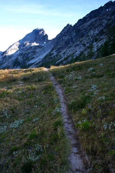
Safely across, I headed over to an obvious saddle at around 6,600ft on a western arm of Mount Maude. I had been deep in shadow till this point. Now, I was dazzled by sunlight spilling over the south shoulder of Maude. Somewhere close above, hidden by deep shadows and the bright sunlight was the ‘trail’ to a 7,700ft saddle. In front of me was a deep 270 degree bowl-shaped basin walled by steep slopes. One part of the trail (the Leroy Creek High Route) lead down into the basin while another headed up the west ridge of Maude. I headed steeply up the second option. Halfway up, the skinny trail started to traverse southeast across scree slopes and a sketchy route appeared where none had seemed possible. Before I knew it I was cresting the 7,700ft saddle. It was 9:15am.
From my balcony in the sky, I decompressed for a bit and enjoyed the sights. To the west were glaciated Clark Mountain and Glacier Peak. Far in the distance to the southwest Mount Rainier and Mount Daniel ruled the roost. To the north Mount Maude’s summit slopes rose gently up to 9,082ft. But, what trumped all, was the sight of stunning upper Ice Lake just a bit below me. Mount Maude wrapped around a large part of the lake while numerous other peaks took care of the rest. Far in the distance I could see the Chelan Mountains rising above smoke from the Domke Lake Fire. Upper Ice Lake itself was a gorgeous deep blue. Pretty meadows and snow-melt fed streams led to the lake.
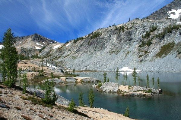
I dropped down to upper Ice Lake on crumbly dirt and rock. Pumice (from an earlier Glacier Peak eruption) coated a large portion of the area. A few larch trees dotted the landscape and ice polished granite created a nice contrast for them. I wandered around before dropping further down to the lake outlet stream. I followed this down steep slopes to a delightful meadow that would lead me to lower Ice Lake. Upper Ice Lake’s outlet culminated in a lovely waterfall that gathered itself in a couple of pretty larch ringed tarns, before finally heading over to lower Ice Lake.
Lower Ice Lake was just as nice as upper Ice Lake. A pretty little island was a nice feature and views of the Entiat Mountains range as well as Spectacle Buttes were stunning. I had the place to myself and enjoyed myself hugely.
The way back was tedious. I spent a bit of time exploring the Leroy Creek High route option for a short stretch, but gave up after realizing that it was costing me too much time on this trip. The Gully was definitely harder on the way back, but careful attention did the trick and I was safely across.
Additional photos: http://www.flickr.com/photos/shahiddurrani/sets/72157601816587499
Overall Stats (including all side trips):
• Distance: 18-19mi
• Elevation gain: 6,820ft
• Hiking time: 11hrs


Comments