Trip Report
Tenmile Falls, Devore Creek — Thursday, Jul. 5, 2007
 Central Cascades > Entiat Mountains/Lake Chelan

This was a strenuous six-day scrambling/climbing trip to some seldom-visited country between Holden and Stehekin. Our group enjoyed dry but very warm weather and summitted four peaks over 8300' high.
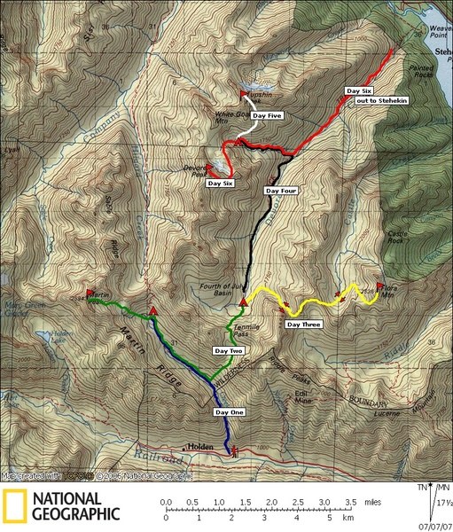
We took the Lady of the Lake from Fields Point to Lucerne, boarded the Holden bus, and were dropped off at the Ten Mile Creek Trail, just before Holden Village. By the way, be sure to carry lots of cash or take checks, as your debit/credit card is not accepted for the boat or bus. We camped the first night at 5600' in the beautiful flower-covered basin south of Hilgard Pass.
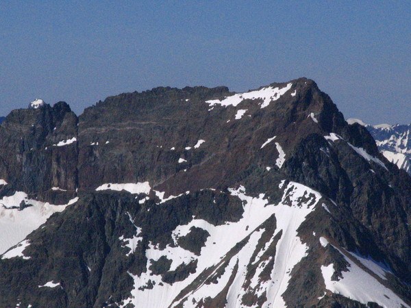
On day 2 we successfully climbed Martin Peak from the east. We had no data about routes on that side. Beckey doesn't mention anything, and I hadn't found any climber reports. We found a class 3 scramble route by climbing a snow finger just south of the 8000' saddle NE of the peak, and then angling up and left across loose, exposed ledges. Small snowfields high on the face then led directly up to the summit.
After descending, we moved camp over to Fourth of July basin. This entailed hiking down valley, then up and over Ten Mile Pass and into the Devore Creek drainage. When we hit the trail crossing of Devore Creek at about 5460' that evening, we found no safe way across the raging waters, and after some discussion, we decided to camp right there. Our planned route to Flora the next day would require us to be on that side of the creek anyway.
On day 3, we did the long cross-country route to Flora Mountain and back. It wound up being nearly a 13-hour day. From the camp alongside Devore Creek, we contoured NE for a half mile through forest, then turned SE to ascend boulders and snowfields to the 7040+' pass between Pts. 7716 & 7990. We next climbed the ridge toward Pt. 7716, cutting off the ridge at about 7450' and heading east toward the broad ridge saddle at about 7360' that overlooks Castle Creek Valley. We dropped down into Castle Creek basin (beautiful larch country) then ascended relatively easy slopes on the west, then southwest sides of Flora. By staying on snow as high as possible, one can minimize the extensive scree/talus travel that eventually leads to the summit of Flora.
After the long return from Flora, my fellow climbers took the initiative to gather several small downed trees, and actually constructed a fairly decent bridge across Devore Creek near our camp site. The next morning, we used this to continue our journey down-valley on the Devore Creek Trail. The trail was in fair condition, and the snow patches persisted down to well below 5000.' We left the trail after crossing Bird Creek and ascended cross-country up to a camp in the gorgeous Bird Creek basin at about 5800.' The route was occasionally brushy, but really not too bad. We had two or three brief struggles in slide alder, but mostly it was good, though strenuous travel. We pondered camping in the flat brushy basin at 5400', but decided to carry on to 5800,' which was more open and had superior views. You don't see established sites in these little-visited basins, so camp with care.
Let's see, now we're up to day 5, upon which we climed the east face of Tupshin Peak. The approach was a nice walk NE up out of the basin, rounding the SE shoulder at around 6700', then traversing moderate snowfields to the foot of the five-pitch route at 7600.' Klenke does an excellent job of documenting this route on summitpost.com. Our climb went nicely, even if a couple of the rappels felt a little shaky (check those anchors), and we returned to camp in the basin in mid-afternoon.
Another early start the next day for Devore Peak. We climbed the snow chute that ascends south from the 5800' basin, then up more snow, eventually gaining the east ridge at 7500' or so. Thanks again to Klenke for great route advice. Things went smoothly on a mixture of rock and snow, with nothing over class 3 until the ""unavoidable 20 foot class 4 step"" a short distance below the false summit. The step is fairly easy, but still a good idea to belay it. An exciting exposed corner and loose gully then lead to the summit. Seeing the original 1940 summit register page intact was quite fascinating.
Our journey out to Lake Chelan was not as trivial as we'd have liked. Devore Creek trail from Bird Creek to the National Rec Area boundary is quite primitive, with a lot of blowdown and brush. Don't plan to zoom down this trail if you're on a tight schedule to meet the boat. Once you cross in to the Lake Chelan NRA, the trail is maintained, with lots of switchbacks, and is pleasant. He hiked down to camp at Weaver Point, awaiting a pre-arranged boat shuttle the next morning to take us to Stehekin. This was far more appealing than walking up to the Harlequin bridge and back to Stehekin that way. The highlight of the entire trip was probably the dip in Lake Chelan's ch-ch-ch-chilly waters, after so many hard days hiking in the July heat.
We were in Stehekin the next morning in time for a breakfast feast at the lodge, a satisfying end to a successful week in the wilderness. Total elevation gain for the trip was close to 20,000.'


Comments