Trip Report
Chatter Creek, Icicle Creek, Icicle Ridge via Fourth of July Creek, Leland Lake & Upper Icicle Creek — Friday, Jun. 23, 2006
 Central Cascades > Leavenworth Area

June 23 - June 27
The short of it:
Icicle Creek Trail 1551 – no snow on trail through Leland Creek juncture. Blow downs and brush. Few bugs.
Leland Creek trail 1566 – Cross Icicle Creek up stream at log jamb, cross Leland Creek down stream at log jamb. Blow downs, brush. Snow covers trail a mile and a half to two miles above the juncture with Square Lake trail. Few bugs.
Margaret Lake – Wild Horse trail 1592 – High water at Doughgod creek for difficult ford. Trail in good shape other then blow downs. Snow on trail in patches by lake level. Margaret is melted out with a third of the shoreline in snow.
Frosty Pass – Snow over trail in woods above Margaret.
Frosty Pass – Ladies Pass - Once on Icicle Ridge (1570) the trail is mostly melted out with snow fields to cross in places. Lake Mary mostly melted, Upper Florence is still 90% snow and ice.
Ladies Pass – Chatter Creek – short but steep snow going over Cape Horn shoulder. Lake Edna is snow and ice. Between Cape Horn and Chatter Creek (1580) 70 – 80% snow covered.
Chatter Creek to Icicle Creek Road – Large snow field from 6200’ – 6500’. The rest of the trail out is snow free with water running over it in places. Most bugs we encountered were at camp 5400 feet on Chatter Creek.
The long of it:
After a frustrating time trying to find snow free areas for my son and me to get into the mountains for five days, we opted to go up Icicle Creek outside of Leavenworth and see what we could find.
Parking at the end of the road (7600) we hiked seven miles up Icicle Creek trail (1551) to the intersection with the Leland Creek trail (1566). Of the seven miles in, the trail was relatively clear. Some blow downs and places, especially just past the juncture with trail 1592, where the brush was quite thick. Pushing through it wearing shorts got our knees a little scratched and something in the brushy mix left a sting.
No snow on the trail with a few patches visible.
We stopped at the large camping area at the juncture with Leland Creek trail. This has a large established camping area which we shared with a party of 11 scouts from Wenatchee. Between the cooler temperatures and the breeze coming off Icicle creek the bugs were, thankfully, pretty minimal.
Our second day we decided to just day hike up to Leland Lake.
As Icicle creek is still running pretty well, we bush whacked upstream a little to get to a good sized log jamb. Even I had little difficulty walking across the double logs lying over the faster portion of the stream.
Once across we pushed back down stream to pick up the trail. Within a half mile, we found ourselves facing a roaring Leland Creek. This time we headed a little downstream and again found an easily negotiable log jamb.
The mile and a half between the ford and the connection with trail 1567 (Square Lake) the trail had little snow and was fairly easily followed.
The trail then switchbacks up a few times before it continues to traverse the valley. Between tree debris, blow downs and patches of overgrowth, you got the impression that another year of neglect and this trail may all but disappear.
The boardwalk over swampy areas has been reduced to rails with bent spikes and no planks. In one section a large cedar fell taking several feet of the trail with its root ball.
A mile and a half or so past the juncture with the Square lake trail we were mostly on snow. Having not been up that way before and tired of post holing, we decided to step across a log to the other side of Leland creek and have lunch on a gravel bank before heading back down.
When we got back to our camp, the boy scouts were long gone, replaced by a four guys that had hiked in from Stevens Pass. They said they were on all snow from before Josephine Lake till a mile and a half south on Icicle Creek.
Our third day we decided to head up high on the east side of the valley. The hike back down to the Margaret Lake trail (1592 – Might have been signed Wildhorse) was quick. The trip up to Margaret was hampered by a lot of wheezing.
In less then a half mile we had to cross Doughgod Creek. Like all water ways, it’s running fast and loud. I’m sure by mid summer it’s an easy skip across the big rocks. For us, it was a slow trip across a log we climbed to up stream.
It’s not that sitting on a log and slowly scrunching forward for maybe 8-10 feet is that difficult. Doing it with pounding white water just below your boots, however, tends to make it feel a lot more intense. Fortunately, my son didn’t have to try and fish me out down stream.
Other then occasional blow downs, the trail was in pretty good shape. We didn’t see any snow until 5000’ feet and not on the trail until we hit the lake level.
Lake Margaret is completely thawed with a third of its shoreline in snow.
The 50 foot falls coming into the lake halfway down its NW shoreline was spectacular. We found our way down to a nice camping spot below the falls on a level piece of ground. The small creek flowing by was currently being used by a number of trout, 6-8” swimming up stream.
Despite the swampy look of the area, it was relatively dry with firm footing and best of all not too bad for biting insects.
Lots of Swamp Marigold and Jasper Shooting Star.
Our fourth day was what hiking is all about. Finding the trail again, we climbed up toward Frosty Pass where we’d pickup trail 1570, Icicle Ridge. On the wooded west side of the slope the snow was still fairly heavy and we lost the trail a couple of times. Just traverse the slope and it’s relatively easy to pick up again.
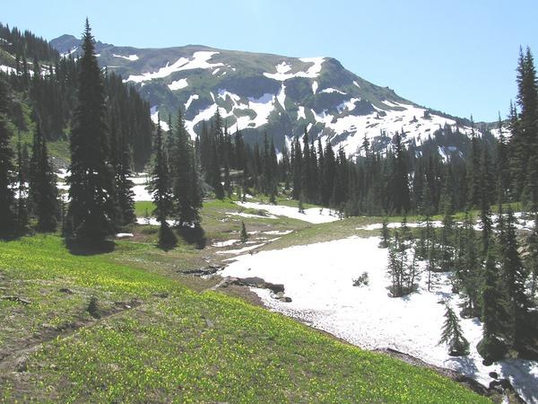
You leave the forest just before the pass. Once at the Frosty Pass juncture everything opens up. The meadows were crowded with avalanche lily in bloom. Blankets of yellow. The trail would still disappear under snow, but once out of the trees it’s so much easier to see where it goes.
Icicle Ridge is what hiking is all about. One huge view point after another. As we continued up trail 1570 we could see the tip of Baker, Glacier, Sloan, Pride Basin, Index, Mt. Daniel, the top of Rainier, etc.. This while walking through alpine meadow with flowers in bloom. Simply stunning.
The trail disappears under a large snow field before making the next ridge. All the snow we encountered was soft and felt like running through sand. It was tough work in some places especially where we had to kick in steps.
Despite the shorter mile count, this turned out to be a tough day of travel.
Once around the ridge we traversed above Upper Florence Lake. Three large snow patches to deal with. Due to the steepness of the slope, we opted to climb above or below to avoid possibly sliding down too fast.
Other then a ring of turquoise water, Upper Florence is still more snow and ice then a lake. The slopes here were covered with patches of white and purple flux (sp?).
Cresting above Florence we traversed around the next cirque to finally get to Ladies Pass. Once again more snow to navigate, but more a nuisance then anything.
From Ladies Pass you can see the end of Lake Alice, melted out down and to your right. The trail continues, however, up and to your left. We looked at the map several times to make sure that the zig-zag line going up to our left was really our trail. So be it.
Three patches of snow to cross on pretty steep grade. With the softness of the snow I doubt we would have slid far if we’d slipped, but it would have been a lot of work to get back up.
Finally toping out, we rounded Cape Horn and got a look down at Lake Edna.
Lake Edna is still all snow and ice with a small amount of melt to indicate where a body of water will be. The upper end of the valley is still 70-80% snow covered.
Sliding down on soft snow is certainly less jarring the pounding down a trail, but having not been across the area before it would have been nice to be able to see where the trail is supposed to be.
After one wrong turn, we did finally make it across the cirque having found a total of 30 feet of trail and three rock carines.
While we were sure we had the right exit to Chatter Creek trail (1580) in our sights it was a relief to finish kick stepping up the last slope of snow and stand on the ten feet of visible trail just before the crest of the ridge. Thank you Green Trails.
Having now seen a soul all day, we just happened to meet a gentleman and his dog just finishing their climb up Chatter Creek and heading in the direction we’d just come.
Chatter Creek trail switched back steeply for a quarter mile plus and then hit a large snow field. Fortunately, we had fresh boot and paw print to lead us down to where the trail is melted out. Once there it was all clear, if sometimes wet and over grown.
We descended 1500 feet in a mile and a half and found a large camping area close to Chatter creek. Our most tired days end and as soon as we’d gotten our packs off, the biting flies and mosquitoes came in the largest and most irritating numbers we’d had on the entire trip.
The next morning the trip back to Icicle Creek Road was a long down hill pound. The first crossing of Chatter Creek from the downhill direction has no bridge. My son, who has much better boots then I, forded. I found some logs a little down stream to pick my way across. Probable looked a bit ignoble, but I made it dry and unscathed.
The rest was a hot, front thigh work out back to the road.


Comments