
I headed out Saturday night after grabbing substantial meal. There were significant areas of cloudiness as dropped down to the Snohomish River valley out of Maltby. By the time I was half way up US 2, the clouds were still there, but they had that unmistakable waning look that always heralds the arrival of high pressure.
The skies were essentially clear once I got over the Stevens Pass. The evening was so pleasant that I kind of hated to bury myself in the trees by heading up the Chiwawa. But it was getting late and it wasn’t exactly a short hop up to the Phelps Creek trailhead. On this particular Saturday night, mine was the 38th car at the trailhead.
I was munching down a fairly good breakfast as a couple climbers arrived and parked vehicle #39. They took off for Mt Fernow in short order.
The run up Phelps Creek was a great warm-up. I was surprised at how soon I arrived at the Carne Mtn junction. I was considering using the Carne high route on my return. So one advantage of that option would be that, once you’re down, you’re essentially done. But there is lots and lots of “down” to that exit, as I understand it.
The trail’s width and an old “Y” junction made it pretty obvious that the trail had been a road. Looking down the slope to the east bank of Phelps Creek, I could see another road that looked to be in pretty good shape.
“Trail 1512” (Leroy Creek – Carne Mtn High Route) is unsigned and not maintained. The route is essentially an “L,” which has been spun upside down. The short leg connects with the 1511 Phelps Creek trail at the Leroy/Phelps confluence. The long leg extends south to access the 1508 Carne Mtn Trail and 1509 Rock Creek Trail. The upper portion of Leroy Basin lies at the corner of the inverted “L.”
There is no sign at the 1511 x “1512” junction. It was interesting to note the faint trails headed uphill just beyond the crossings of a couple of creeks. It didn’t appear that these offshoots went anywhere. It looked like they might be the result of overanxious hikers looking for the Leroy Creek junction.
The key is to lean back and enjoy the stroll up the road. As you pass the wilderness boundary sign, just visualize a second sign reading: “Leroy Basin Trail, 1 Mile.” Leroy Creek is unmistakable. I could hear the lower falls long before I could see the crossing. The creek is running through about three channels in swath of rock, which is about 100 feet wide. The trail hops across each channel. About midway across, a vertical 8-inch log peeks out of rocky mess.
The trail up to Leroy Basin is immediately north of the creek crossing. In fact the northernmost channel of the creek is on its way to undercutting the trail. About a 50 yards uphill from the junction, a small sign states that the trail is “not maintained.” The trail is really too steep to maintain is a professional sense.
Soon after I started up this leg of my trip, I was overcome by a sense of September. The sky was blue. There continued to be exactly zero insects. The climbers that preceded me had removed all the spider strands. The trail tread was moist. And best of all: cool air was cascading down on me. As I marched up, I took note of the steep grade and uneven tread off the lower section. I wondered whether a person would be better off descending on the maintained Trail 1508.
I noticed that the fir trees along the lower portion of Leroy Creek were distressed. Most of this year’s new growth had a really bad, “died-on-the-vine” look to it. It gave the forested slope a brown tinge.
I passed a couple backpackers who were descending after summiting Mt Maude during the weekend. They didn’t have much good to say about the western scramble approach. They had gone up via the Ice Lakes approach and slid their way down the west approach. They believed that the more scenic east approach was actually quicker than what it might take to claw ones way up the westside gully. That conversation solidified my inclination to go around the south end of Maude and hit the South Shoulder from east.
As I continued up, Leroy started getting pretty loud again to the south of me. I took that as a signal that I was nearing the final push up to the lip of the basin. At around 5000 feet, a welcomed viewpoint appeared just off the trail to the south. There stood Seven Fingered Jack and Maude.
At about 5300 feet, the trail angled east to cross the north branch of Leroy Creek. This minor stream is labeled Leroy Creek on the maps, but it’s not significantly bigger than its brethren to the south. A couple of extremely average tent sites exist near this crossing. They have no view. Another 700 vertical feet up the line are the upper camps and the open meadows of the basin.
I took a minute to study the east aspects of Jack and Maude. Northwest Maude had a lot in common with the top of Seven Fingered Jack. The sun was cooking up batches of clouds and the SE winds were pushing them over the fingers of the two mountains. This was a little too Septemberesque for my tastes. I wondered if I should have given a day for the region to dry out from last week’s rain spell. I couldn’t really complain. Conditions were “mostly sunny,” as forecasted. But I was hoping for a little better return on my 5700-foot investment.
I left “Camp 6000,” and continued east as the trail skirted the south margin of the meadow. It quickly turned right and ascended south into sections of small trees. As the trail parallels the foot of Maude, it’s in and out of trees. There’s a little up and down, but it’s generally up. It was great country to be traveling – until the boulder field.
Just south of a creek crossing, the trail disappears as it crosses a broad plain of talus. Cairns led me through the rubble, right up to the north bank of the 2003 flood channel. This chasm is almost a destination in itself. A gully in the west face of Maude has been polished clean. Its contents apparently helped scoured a 25-foot deep trench in the existing plain of till. The trail stops at this obstruction. I hate to say it, but many casual hikers should consider stopping at this point as well.
The banks of the floodway have yet to break down. So the opposing faces are still fairly vertical. A load of unordered boulders is suspended in a brown dirt matrix. Each face is peppered with a load of unsorted rocks and boulders. These are suspended in a granular dirt matrix with very little strength. Let’s face it: lots of folks cross the trench; I crossed the trench. But the feature remains an excellent place to mistake a landmine for a handhold and get bonked. Or worse.
Previous reports indicated that the floodway could be bypassed by paralleling its north bank up to the headwall. The chasm could then supposedly be crossed via the exposed rock at the toe of Maude. I took this alternative to be the more conservative means of crossing. However, the recent rain gave the dirt matrix a damp, somewhat cohesive character. So, I practiced a little on the north bank and found a technique that made the crossing reasonable for the conditions I found that day. Not prudent; just reasonable. I can’t recommend scrambling down and then back up the faces of this trench. Nor, would I recommend the headwall crossing. If I had it to do over again, I’d check farther down the slope to see if the depth of the trench and the angle of the sidewalls moderate any.
I will say this: to the extent that I interacted with a rock, that rock went tumbling. The size of the rock didn’t really matter. If I left it alone, it didn’t necessarily pop out and fall. But if I touched it, it either fell or became necessary to remove. Remove too many loose rocks, and you get an underlying boulder in your lap. Unless you happen to be a “low cost” sewer contractor, you may not like getting into this little feature until it’s had another winter to erode.
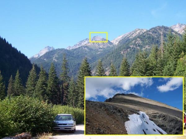
Continuing south, I came across what I took to be the toe of the scramble route to the south shoulder of Maude. What was much more obvious was the 6,870-foot saddle that dominated the south end of the Leroy drainage. I continued south, ascending through some trees, and then across another talus field. The final stretch to the saddle included some welcomed switchbacks. I stopped for an early lunch to take advantage of the grassy south slope of Saddle 6870.
Saddle 6870 defines the south end of the Leroy Creek drainage and a small, unnamed basin located south of Leroy and north of Chipmunk. The saddle also marks the junction between unmaintained ""Trail 1512” which passes over the saddle and the Ice Lakes trail that shoots up the east side of the saddle. The Ice Lakes Trail is fairly clear as it heads up just north of the saddle crest. It seems to disappear in the heather and Christmas trees. However, it reappears to the right (south) of its apparent endpoint. Then it continues up and east.
Below the trail, and to the south, is a large west-facing bowl that forms the head of the unnamed basin. This cirque is guarded by Point 6888 on the north and Point 7108 to the south.
As I gained more elevation east of Saddle 6870, I could really see the extent of “No Name Cirque.” The east (back) face of the cirque rose up to form Saddle 7620. The left face of the cirque rose up and merged with the southwest toe of Mt Maude. The easterly route over to and then up the larger saddle was kind of a fun segment. It supports an impressive bit of travel and elevation gain without a lot of discernable trail. I felt a little like a fly on a wall. Flies on the face of this Saddle, had best have a pair of poles.
I had been a little preoccupied with foot placement on the final push up to Saddle 7620. So when I arrived on top, I took advantage of the higher vantage point to see what the weather was up to. There seemed to be very few clouds upwind. Those already in the pipeline were scattered, flat, cumulus clouds. It looked like the afternoon and evening would bring continued clearing. This agreed with the forecast, and made a summit camp worth doing. It also meant that I’d be carrying all my gear, plus water, up the hill. I guess that’s why the legs have a low gear.
With my tour guide business now out of the way, I spent the next few minutes just enjoying the sight of Upper Ice Lake, framed by the two Spectacle Buttes. The scene was very impressive. If the summit of Maude turned out to be untenable for any reason, Ice Lake would sure be a worthy fallback.
Because of cliffs and towers, the south shoulder of Maude is not accessed directly from Saddle 7620. I needed to drop down to a snow shelf above Ice Lake to begin the ascent. But I also needed to get down there and grab some water anyway, so ceding the 160 feet was no biggie.
The most obvious route down off the Saddle 7620 is more of a hoof path than a boot path. It’s a prominent path, but it started to look a little impossible as I scanned its route down the slope. I deviated to the right and descended in a broader arc. From below, I could see that my original track would have terminated at the top of vertical wall of snow.
I came across a spring that apparently was the outlet for a confined snowfield higher up on the ramp to Maude. As I bent over the spring, I struck me that I had not be buzzed by so much as a ladybug all day long. The bugs were gone. Where, I did not care.
The trudge up to Maude’s south shoulder begins with an approximate northerly heading. After passing a few inclined snowfields, the route turns left and climbs up to the steep east face of the south shoulder. I chose to bypass the snow. Others might make a point of using it to avoid the talus travel.
The final westbound leg up to the shoulder is a little steeper and looser. It takes advantage of rock outcrops, but is primarily scree. In addition to the angle and poor traction, a third factor in this segment is the leftover cornices clinging to the sheltered east face. The snow itself was static enough to be no issue. But it carries some rocks that, if released, would be hard to react to before they were right on top of a person. Fortunately, the route is in the cross hairs of the perched snow for just a few dozen yards.
After I got up on the shoulder, I could see how it could be such a prime cornice factory. The ridge top and east face must treat snow the same way the rear window on my van treats road dust. The profiles were similar.
The trail up the slope sticks to the west side. It actually adds a little interest to an otherwise lackluster trek. The rocky plain was sprinkled with compact wildflowers. They were actually pretty detailed and vibrant if you looked close enough.
The skies had pretty much cleared off. But the few remaining clouds seemed bent on tracking right above Maude, Jack, and Fernow. But I had to admit that the repeated shading effect was kind of nice. The breeze was just strong enough to create a rushing sound in my ears. I threw my headphones on and caught a fresh weather forecast. The quiet produced by the headphones was a welcomed change.
As I arrived at the summit block, I found that the skies had just about cleared and there was nothing left in the bullpen to the southeast. I searched above the north face for a pair of crampons misplaced by a previous visitor. Not finding them, I headed up the summit block to the top. The view was even more than I had expected.
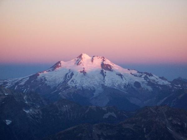
I hate to start listing names, because a quick review of a map could give a much more complete listing. But the visibility went past Adams to well beyond Baker. To the northeast, were craggy peaks of the North Cascades and southern BC. There were probably 60 miles of mountains stacked up as far as the eyes could see to the north. To the southeast were broad patches ground painted in ""harvest gold."" Clark and all the other “White River Boys” stood high above Buck Mountain, which stood above the little jersey barrier of Phelps Ridge. The biggest presence was the freshly whitewashed Glacier Peak. To the immediate northwest were the spires of 7FJ, upstaging the similar features found on northwest Maude.
With the wraps taken off the sun, I was actually enjoying more heat at 9,000 feet than I had all day. I soon located a great bivy patch on a dirt bench just below the summit. The site would provide shelter from the wind and it had really great counter space. The neighbors seemed friendly enough but had a habit of whistling a lot. I dined on the finest dinner money could reconstitute and then enjoyed the approaching sunset. An eagle put on an air show for me in the gap between the main summit and the northwest towers.
One thing about ridge top camping is that you don’t get much evening. It’s bright daylight right up to sundown. Then it’s night in a big way, often with high winds. Forest fires up north really supercharged the sunset. A Trooper’s light bar couldn’t produce a redder light.
I got bundled up for bed and found that I needed to use my boots for a pillow. I was wearing everything except my raingear. Since the moonrise wouldn’t come until after midnight, I had a lot of time to enjoy meteors, satellites, air traffic, and the Milky Way. One meteor just exploded in the southwest sky. No tail. No streak. Just a big flash.
When the moon did arrive, it was at about 32% power. So the lighting was strong enough to get the snow to glow without lighting up the whole works. The light made NW Maude look like a movie set.
In the morning, the air clarity enlarged everything and drug it 20 miles closer. I could now distinguish St Helens peaking around from the left side of Rainier. David and dozens of other intermediate peaks appeared with far more definition. The wildfire smoke had really laid down overnight, and filled the Lake Chelan basin wall to wall. There was not a cloud in sight. Each passing minute brought more light to more territory. Somewhere off to the south, a lone coyote yipped.
I had a real hard time getting motivated to load up and head down. At 40 degrees, it was not particularly uncomfortable, especially with the sun up. When I finally did shove off, I left my pant legs on and wore a long sleeve shirt. That turned out to be a good move. The wind kicked up and made it quite chilly on the way down.
When I reached Saddle 6870 at the Leroy/Carne/Ice junction, I stopped for a little brunch. At this lower saddle, I had a choice to make. I debated the merits of a Carne versus Leroy exit. Scenery was not a factor since each would be anticlimactic after what I had experienced on top. I could avoid having to cross the floodway again if I headed south. The Leroy option would be a constant elevation loss; the Carne option would entail a lot of pointless up and down. I headed north for the Leroy descent.
At the floodway, I found that the trench faces were dusty dry and noisy with spontaneous erosion. Rather than press my luck, I decided to resort to my ace in the hole: the headwall crossing. The northbound version of this alternative starts out okay. An island of rock nearly fills the trench, and is in contact with the south bank. A short step from the rock leads to a ledge on the face of Maude, just north of the gap. Getting from this high ledge to the talus field, north of the trench, is a bit of an exposed scramble. Climbing up the rock face in a southbound crossing might not be that bad. The rock is fairly clean and the steep slabs are few. I found the northbound downclimb to be right at the end of my comfort level. It is not a hike.
My exit down Leroy Creek was incredibly hot, stagnant, buggy, and dusty. The run out to the trailhead was about the same, only a few degrees hotter. What a difference a day can make.
Comments