

A few of us were booked to go to Ross Lake for a few days, but unfortunately the fires shut down the area so we scrambled for a Plan B and wound up backpacking at Goat Rocks Wilderness … what a spectacular place we live in to have this as a “backup” option!!
We did a clockwise loop from Snowgrass TH --> PCT --> Sheep Lake/Nannie Ridge --> Return via Walupt Lake and the Klickitat Loop trail.
TL;DR: Goat Rocks Wilderness: didn’t see any goats, but beautiful scenery, abundant campsites (if timed right), great range of microenvironments: alpine, pine forest, bog, lakes, waterfalls, streams. One of the nicest places in the state to spend time in the wilderness.
Road: easy driving to the closest town of Packwood. Your favorite map app will lead you to the Snowgrass trailhead from there... 45’ once you get on the forest road, which has decent signage and in OK shape: medium rough for most of it, but no major issues.
Snowgrass TH: well signed. Ample parking. No water. didn’t see a privy.
Day 1 trail:
Snowgrass Trail to PCT; 5.81mi, +1780ft
Not a lot to report on this first section of trail. We had the early energy of people just released from the car and excited to get into the wilderness. The first 3 miles or so were relatively mild elevation gain through mellow forest. As it starts climbing, the trees thin out and it gets rockier but the views open up more too. It was cloudy, with some peaks poking through.
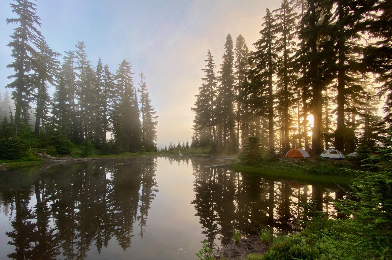
We set up camp near the junction of SG and PCT. There were a few campsites just proximal to the SG/PCT intersection and then several more going further North up the PCT. It was fairly windy that night so we were lucky to be in a stand of trees, compared to some of the more exposed camp sites further up.
After we made camp, we went for Old Snowy and The Knife. 4.58mi, +1363ft
Very interesting geology with cool rock shapes and colors all along the hike as well as a brief clearing of the clouds, allowing a view of Goat Lake. The flowers thinned out and it was just rocky after that. Nearing the top, there were 2 snowfields, one of which was short, the other was about 100 yards and had a steep slide off to the west. The trail was wide enough and gentle grade so we just took our time, but poles were very helpful. Spikes would have helped too, but you’d be taking them off immediately before & after. The top, unfortunately, was totally socked in. One of our group came back the next morning to better skies and had amazing views of Mts Rainier, St Helens and Adams with an inversion layer over the lands below. Of note, there is a narrow horse/stock trail (“Sketchy Horse Trail”), which is right on the ridge and a (slightly less sketchy) hiker trail, which is longer (and steeper) but probably safer.
Day 2 trail:
PCT -> Cispus Pass -> Sheep Lake -> Nannie Ridge 7.18mi, +531 ft, -1300 ft
The PCT to Cispus Pass section of the trail has a well-deserved reputation for its spectacular views. The trail leaves the meadows and mountain springs for a ridge line over a valley with views at every turn. There were a few amazing waterfalls, hillsides covered in wildflowers, freshwater springs bursting from the ground, craggy peaks of all shades of gray, red, brown and white. It was one of those places that looks straight out of a story book … everyone we passed was smiling like we were all sharing the same dream. The trail then ascends over the ridge into Yakima Indian Reservation briefly and then comes around to Sheep Lake where we left the PCT to the Nannie Ridge trail.
We stopped for lunch and a swim in Sheep Lake. The water level was down so there is no outflow currently, but still clear enough to see a salamander on the bottom. There were a few campsites around the lake.
We continued from Sheep Lake for another 1.5-2 miles and camped at a cozy little pond just shy of Nannie Peak which has room for a few tents. Some bugs early in the evening but they didn’t like the cooler night temps. Amazing stars and reflections off the lake of the trees and craggy ridge surrounding the pond. In the morning, there was another cool inversion layer in the valley.
Day 3: 10.96mi,+1781ft, -2754ft
We broke camp, said goodbye to the pond and made our way south along Nannie Ridge.
Along the way, we dropped our packs to do the spur to Nannie Peak, which was medium steep, easy to follow and pretty. The views from the top were spectacular: snowcapped Mt Adams, boldly rising from the south and Mt St Helens, subtle, off in the distance.
After that, we continued down the forest through 2+ miles of switchbacks. It was the least interesting part of the trail so far. There’s a flowing stream about 1 mile up from Walupt Lake where we cooled off and topped off our water.
We burst out of the trail at Walupt Lake, stumbling into a hazy memory of vacations past: a beautiful mountain lake dotted by a handful of campsites and people enjoying the water. We all cooled off again in the lake and girded ourselves for the final leg back to Snowgrass.
Three of us ditched our packs and trudged on to complete the loop to get the car back at Snowgrass while one brave member of our troop sacrificed himself to stay behind and guard the stuff (at the picturesque lake, reading, swimming, napping … wait a minute !).
The Klickitat Loop section of the trail has seen better days … only a few blowdowns, but the crossing of the Cispus was not easy to find and the boggy area afterwards was pretty thick to go through. The trail crosses a few old forest roads and the entrance to the final section between Road 2150 and the Snowgrass TH was like walking through bushes so we opted for the road for the final stretch. The trail finding was not terrible and the forest and river crossing were really nice, but this area seemed mostly forgotten.
Side note: The bathrooms at Walupt were hazardous to one’s respiratory mucosa. The smell was bad, sure, but just being in there with the door closed brought tears to my eyes (in a toxic way)
Gear: standard stuff. No microspikes for the minor snowfields. Poles were helpful in the slippery snow as well as elsewhere. Def bring a GPS or know how to do some moderate route finding. A little bit of bug spray.
Flora: tons of wildflowers, especially at the area between the Snowgrass trail and PCT junction and east from there. Of all of the hikes I have been to this year, this hike (albeit longer) had the widest variety, most numbers and biggest groups of wildflowers. Really gorgeous scenery all around. Lots of variety amongst the mushrooms, trees, ground cover, etc as well.
Fauna. Unfortunately, no goats … their absence became a running joke amongst us and the other hikers we ran into. Despite that, we saw a decent amount of animals: marmot, chipmunk, pika, frogs, salamander, osprey, grouse (aka “fancy hen”), otter (Walupt Lake).
Crowds: we did see other hikers & backpackers, especially along the PCT (including some who clearly had done the whole thing!), but never felt crowded or too busy. Likely just good luck and choosing to start the trip on a Sunday.
All in all, an amazing place to spend a few days in the wilderness with pals. Beautiful, memorable and worth visiting again.


Comments