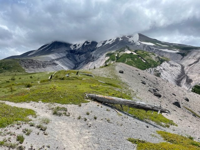
Trail is in great condition and weather window is perfection for circumnavigating Mount St. Helens! Saw lots of backpackers and a handful of day hikers, but only a couple other runners.
TL;DR: A few blowdowns on June Lake Trail to access Loowit, but fairly manageable. Still some snow patches to cross, most easy and great boot pack from hikers/runners previously so no route finding needed. Trail is very technical, and dips in and out of creek beds (most of which are dried up), and is very exposed for majority of the trail. PLAN YOUR WATER, large sections without access!
TRIP DEETS
Parked at June Lake TH and hiked in to June Lake camp (approx 1 mi) Friday night. Saturday we did a self-supported ultra trail run from June Lake to Loowit Trail junction and went clockwise all the way around and back to June Lake to camp. Hiked out from camp the following morning back to the TH.
TRAIL CONDITIONS
June Lake Trail: wide, well traveled, a couple blow downs getting up to Loowit from June Lake.
Loowit Trail: overall the tread is soft and dry/sandy. There's a few woodsy sections with a nice pine pack, but otherwise a pretty rocky and technical trail. There's a few miles of talus/boulder fields - just looks for the rock cairns or wooden posts for route finding. There's a couple of snow patches still on the southwest side. Nothing difficult to pass, a couple spicy spots that are steeper, but crossed without traction or poles. A couple creek crossings that required going up and down to find the best spot to cross. Also, a couple of rope climb/descents out of the ravines. Trail is very exposed so plan accordingly with weather.
TRAIL RUNNING
As mentioned above, this trail is fairly technical. If you're like me, that means a little slower going. I felt like every time I got in a nice flow (running in stride) then it would get abruptly stopped by a snow patch, or rocky section, or creek crossing. It was hard to keep momentum in my opinion, but still amazing views, and never felt too strenuous as far as climbing/descending. I packed my spikes and poles, but didn't end up needing either for majority of the trail. I pulled the poles out for one creek crossing, and certainly could have used them in other sections, but not necessary, so would be runner's preference on this one.
BACKPACKING
We saw lots of backpackers on this trip making their way around. This would be an amazing trail to backpack in a couple of days. There are a few techy sections (rope climbing, steep, loose tread traverses, talus fields etc.) that I was happy to not have heavier pack to manage, but clearly very doable as many were. All of the campsites we passed looked very nice and well maintained. A couple didn't seem close to water, so I would review where you're staying and closest water source. Main note would be on water sources if backpacking as noted below, and don't rely on map as many of the "creeks" are dried up and no current running water.
WATER
We made the mistake of not filling up reserve water to start, and there is NO WATER from June Lake until mile 11 at South Fork Toutle River. We did hear some snow melt trickle in a small creek around mile 9 and went off trail to collect (since we were uncertain when the next actual water would be). Unless you want to collect snow to melt, water is very scarce at the moment, so I'd plan to carry some. After that point there were more dry patches, but none as large or significant. We each had a liter flask we would carry on our back in addition to our accessible drinking flasks, and that system worked well for us. We were never without water at that point. Just be mindful, and my advice would be carry more than you need in case you hit a few dry miles.
ANIMALS/BUGS
We heard marmots whistling, and plenty of birds as well. Only saw a couple chipmunks and a field mouse though. Did see some deer scat, but no animal sightings on this trip. You will notice how quiet it is on the North side where the blowout was, which was something unique and cool. The bugs were not bad at all along the trail; however, we did have some bugs at June Lake Camp. They weren't out of control but definitely noticeable, and more so at the trail head even.
OVERALL
This was an awesome experience, and would highly recommend to anyone up for an adventure and getting to see all faces of a volcano, and the varied terrain that comes with it. It definitely has some technical sections, but trail is in great condition and well maintained, and no route finding necessary, which means enjoying the trail and views even more. I was quite pleased going clockwise and would likely do it that way again, and certainly would recommend that direction to others. The sun stayed behind us all day instead of in our faces, and I enjoyed the boulder field "warm up" and getting to the more open sections at the end of the day that were easier to travel. Of course this depends on your start/exit point, but clockwise from June Lake was great!
Happy trails!


Comments