(Tl;dr: Some parts of trails non-existent or in terrible condition. Loop not recommended unless you love route-finding and bushwhacking.)
I started from the Cash Prairie TH mid-morning. Bethel Ridge Road (FR 1500) and FR 199 are in fine condition, suitable for any car. There were no other cars at the TH.
I headed out on Ironstone Mountain Trail (1141), passed the junction for Burnt Mountain Trail (1140) heading north, which I noted as I would be coming back that way, and continued below Burnt Mt, detouring up the well-worn use trail to the summit. The trail to that point was in fine shape. Continuing off of Burnt Mt, the most obvious trail curves around Burnt Mt heading north until it ends shortly at a tree and a gully, followed by a steep hard-packed slope. This is not the trail. Instead, before the above-mentioned “trail” ends, shortly after you come off the summit user trail, look downhill to the left and you’ll see some small cairns and the trail continuing in the distance. That’s what you want.
Continuing on the Ironstone Mt Trail, I then bushwhacked to the base of Shellrock Peak, and started up the ridge. Although the way up the peak isn’t difficult, the large boulders and dinner plates were pretty loose and I didn’t feel comfortable continuing on the long ridge solo. Somewhat disappointed since the ridge does look very cool and unique, but with thoughts of a boulder rolling on my ankle, I turned back and continued on the trail.
I arrived at Fox Meadow around 2:00pm and set up camp. There are at least two established hunters’ camps; there may be more, but I didn’t go around the full perimeter of the meadow. It was a fine place to camp and relax, but a bit buggy in the evening.
The next morning I continued on Ironstone Mt Trail with the goal of camping at Strawberry Meadow, which the Forest Service describes as having “good overnight camping” in their description of the Burnt Mountain Trail. Heading up towards the saddle below McNeil Peak, there are a couple places where the trail isn’t obvious, but after McNeil Peak is where the fun begins. I started off on the most obvious trail from the saddle, heading downhill into the trees, but it quickly turned into a game trail and faded. After some bushwhacking, I was back on track, but the trail all the way down to the Rattlesnake Trail (1114) junction is off and on nonexistent and I was regularly checking my GPS to make sure I was on track. I was relieved to get to the signed junction and see that the Rattlesnake Trail appeared well-defined, as I was ready for some easier hiking and less route-finding (little did I know….)
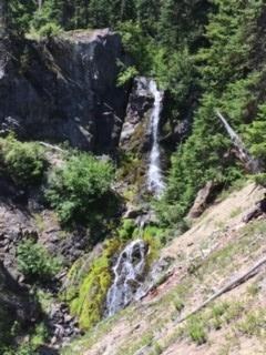
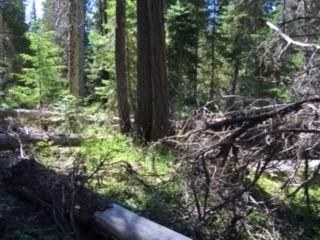
I took a right on the Rattlesnake Trail and headed down. For a while, although there was a quite a bit of blow down, the trail was pretty easy to follow, and most of the worst blow down had use trails around it. There’s one good view of a waterfall, but other than that, the trail isn’t especially scenic. There are a couple of creek crossings where the trail on the other side is not immediately obvious, and the more I descended, the worse the trail became, until I was once again regularly consulting my GPS.
I arrived at Rattlesnake Meadow, which is somewhat marshy and not nearly as nice as Fox Meadow. As I crossed, I looked for the cut off to Shellrock Peak Trail (1132) and did not see it. I didn’t look too carefully though, so take that with a grain of salt. There did not appear to be camping spots at Rattlesnake Meadow. I quickly came to Strawberry Meadows, which is similar to Rattlesnake Meadow in appearance. I headed around the perimeter, looking for a place to put my tent. There was none. There was either thick brush, or tons of downed trees. I found zero spaces suitable for my small 1-person tent. Quite discouraged, I headed on, knowing there was a creek immediately ahead and hoping there would be a flat spot there. No luck.
It was about 2:30PM at this point, and with no viable place to put a tent, I decided to make my 2-night backpack into a 1-night backpack, and just head out. I knew it was about 3.5 miles up the Burnt Mt trail (1140), then an easy mile-ish back on the Ironstone Mt Trail I came in on. However, based on the deteriorating quality of the trails so far on my trip, I was a bit concerned that that Burnt Mt Trail was going to be non-existent. I headed up to check out the Rattlesnake/Burnt Mountain junction and although the trail was extremely steep and rough (as I knew it would be), it was very well-defined. However, I did not see any evidence of the Rattlesnake Trail continuing at this point. There was not a junction, just the one trail continuing – but luckily for me it was the trail I wanted.
Since I had been planning to camp at Strawberry Meadows, I was almost out of water, so I went back down to the creek to filter before beginning the very steep climb up Burnt Mt Trail. Although I could see that the Burnt Mt Trail started off “promising” (relatively speaking of course – at this point, any visible trail made me very happy), I still had concerns it would disappear, and I’d end up bushwhacking and route-finding the almost-3000’ vertical feet to the Ironstone Junction. If that happened, and depending on how bad the terrain was, I was not sure I’d be able to make it out before dark, so I filtered a couple extra liters just in case I had to bivy and find my way out in the morning.
I started up after filtering, and the trail shortly disappeared completely. The next couple of hours were spent groveling my way up the extremely steep slope, crawling over endless blowdown, and occasionally feeling ecstatic to see a cut log. It was very difficult, both mentally (mostly because of being solo) and physically, and to keep my spirits up I would call out things like “I see you, cut log! Thank you, cut log!!” It’s not like there was anyone around to hear me being crazy! Finally when the terrain flattened out a bit around 6,000’, some semblance of a trail again appeared, until I hit the junction with Ironstone Mt Trail, which I practically kissed. There was one other car at the TH when I arrived around 6:30PM. Zero people were seen on the trip.


Comments
Awesome trip report, sounds like an adventure! It's nice to hear the condition of Rattlesnake in that section.
Posted by:
Froof_D_Poof on Aug 01, 2019 08:28 AM
Thanks!!! I couldn't find much info on some of those trails (obviously, which is why it turned out to be an adventure - ha!), so hopefully the info will help somebody in planning!
Posted by:
Walkin' Fool on Aug 19, 2019 04:03 PM
Wow, thanks for the detailed report! I was looking at my map and thinking I could do a lollipop loop of Ironstone Mt, Shellrock Peak, and Burnt Mt trails but guess that's a hard nope!
Posted by:
wishfulwanderer on Jul 11, 2020 12:55 AM
Glad it was helpful! It does look good on paper, doesn't it? :-) I think an out and back starting from Cash Prairie TH would be worthwhile, hitting Burnt Mt and Shellrock, then camping at Fox Meadow and going up Ironstone Mt. That would be a good, fairly leisurely (IMO, it's all relative, of course) 2-day trip, or a helluva dayhike/run. There's also McNeil Peak you could get from Fox Meadow, to make it a more challenging 2-day or a very leisurely 3-day.
Posted by:
Walkin' Fool on Jul 12, 2020 05:01 PM