
TL:DR version - left fork of S. Fork Tieton loop to Surprise Lake is fine. Right fork has at least 100 downed trees, is difficult to navigate, and at one point the trail disappears completely. Use caution.
A word on directions to the trailhead. Follow the print directions listed on this site. Otherwise, Google Maps will try to take you down a forest service road that doesn't exist (if you're heading East on Hwy 12).
DAY ONE: I'm feeling stoked as I pull on my backpack, ready for my first solo overnighter. I'd read some trip reports talking about downed trees, but the latest one made it sound like the loop was passable. So Sazi the Adventure Hound and I head out. The first mile or so of the trail is delightful - passing through beautiful meadows. We get to the bridge over Conrad Creek, where we take our first long break. While the bridge is damaged, it is passable. On to the fork in the trail. We go left, and start heading up to Surprise Lake. Several switchbacks offer pretty views of the Goat Rocks, and a little hidden waterfall.
We set up camp and settle in for the night, enjoying the scene of Surprise Lake with the Goat Rocks in the background. There is one other party at the lake, but that's it. The night passes uneventfully. I study my map and Gaia, and realize that it'll be a shorter day if I do the loop tomorrow instead of an out-and-back to the high point and a descent of the way I came in. I decide to see how I feel in the morning.
Little did I know.
DAY TWO: I wake up around 6:30, read in the tent until my stomach starts growling, and eat my breakfast to lovely views of the lake. I'm feeling pretty adventurous, so I decide to do the rest of the loop before hiking out. I leave camp around 9 AM.
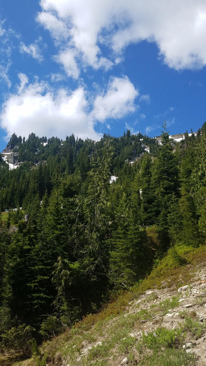
The trail passes through more pretty alpine meadows. I get a good look at the approach to Mt. Curtis Gilbert, via the way trail to Warm Lake, and mark the spot on my Gaia GPS. The views from the high point of this basin are incredible - I can see the entire South Fork Tieton valley below, with the Goat Rocks behind and to the left. After admiring the view and taking far too many pictures of the mountains and the blooming wildflowers, I start descending back into the valley.
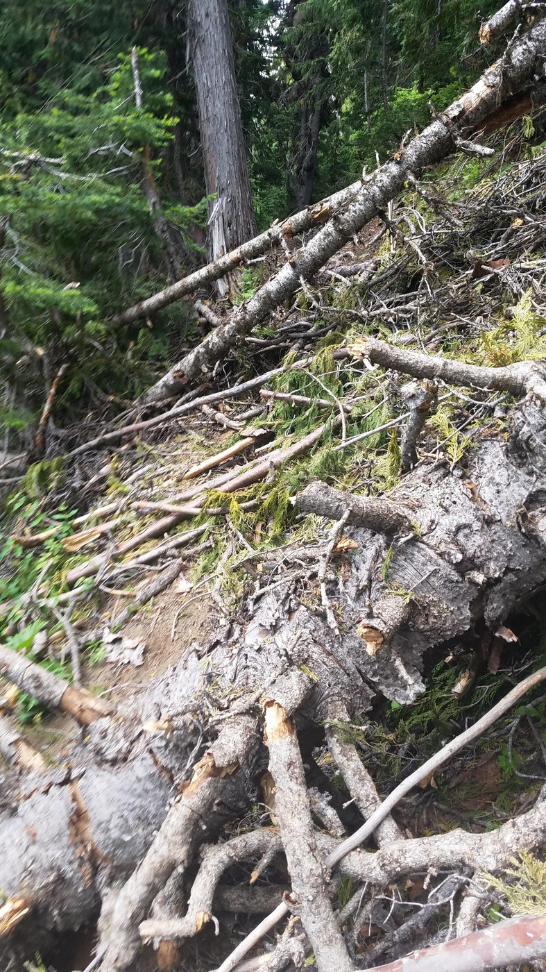
Then the blowdowns started. According to Gaia, I was at approximately 5100 feet with 1.5 miles to go before I hit the loop junction. This was slow going. While Sazi the Adventure Hound could jump over or go under most of the downed trees, I had to walk around or maneuver over most of them. There were over 100 downed trees within this stretch of trail. At one point, I saw a random "Trail 1120" sign in the middle of nowhere - making me wonder if the trail had been rerouted at some point. I see a giant pile of relatively recent bear scat, and start singing loudly so the bear knows I'm around. I don't see anything, but Sazi smells the bear and gets behind me. I slipped a little at one particularly nasty washout, but at no point did I think that maybe I should turn back. There was a clear trail to follow.
Until there wasn't.
At about 4400 feet, I detour around what I (hopefully) think is the final washout...and the trail just stops. I look around a little frantically, seeing if I can figure out where the trail goes. Nope. Nothing. I check Gaia and my paper map, and realize that the S. Fork Tieton is pretty close. So I start heading south for the river, thinking that I can just follow it back to the trail and to safety. I start getting really disoriented while in the meadow, trying to navigate downed trees and other obstacles hidden in the mud beneath my feet. Where did I get off track? Was I even on the right trail? How could this happen?
I hit the river and give the dog a high-five. We start following it...until I see the Mother of All Blowdowns. I check Gaia - and Gaia says I'm on the trail, which is impossible because there is no trail. I can't safely get around the blowdowns. I'm by myself. I don't know what's on the other side of the river - looks like the trail on the other side has started switchbacking up by this point. So I sit down on a log. I have a snack. The dog brings me sticks to cheer me up. I take out my InReach Mini and I push the SOS button.
Emergency services text me right away, asking for status updates. I'm not hurt - just off-trail, lost, and scared. Unbeknownst to me, they call my boyfriend and my parents. I've sent Matt a couple of texts letting him know the situation, and he starts messaging me back. The Yakima Sheriff's Office SAR team gets mobilized. I settle in, eat some more, and prepare for what I know is going to be a long wait. I've just taken a bunch of Mountaineers classes as part of my Scrambling class, and I know that it will be at least 8 hours, if not more, until I'm back to my car.
After 2.5 hours, Sazi, who is the best dog ever, hears voices and smells horses on the other side of the river. I start hearing people talking to each other. "Over here! I'm over here!" I yell. I spot the party up above on the trail. One of them, Brandon, dismounts and walks down to the river. I tell him what happened. He tests out a downed tree and says "it's safe to cross." We gather my gear and he helps me across. As we are doing this, I hear other voices coming from the same direction I came from. It's a pair of trail runners. "I've run this trail so many times - it just disappeared. Never happened before," one says. We all get across the river and back on track. The trail runners take off. The horsemen leave (Brandon, if you are reading this, thank you so much!). And I start hiking out again.
I pass what clearly is a disused trail junction (deliberate downed trees), check my Gaia...and see that Gaia thinks that this is where the trail is. At the actual trail junction, I put a waypoint. GaiaTopo didn't have the trail on their built-in maps, so I downloaded USFS and USGS maps and was using those along with my Goat Rocks Wilderness map. (Note: I can't confirm yet whether or not the trail was rerouted - but I have a message in with the Naches Ranger District, and have been assured that this person will call me back.)
My InReach Mini keeps beeping, so I look...and realize that whomever is on the other end never got the message that I no longer needed SAR to come out! The InReach doesn't work very well when there is an obscured view of the sky. I stop in an open meadow area, cancel the SOS, and let the first responders know I am OK and walking out. Two more trail runners come into the meadow, and I let them know that the righthand side of the loop is really nasty. They ask "are you the person with a note on your car?" Yes I am! I'd left a note on my car with my route and my description, and a note to call 911 if I wasn't back by 8 PM on Sunday June 30th. "We were wondering if we'd see you," they tell me.
The rest of the hike is uneventful, save for turning my ankle in a flat spot (d'oh!). I hike out. Sazi enjoys playing in the meadow.
When I get to White Pass, my phone dings with a gazillion messages and voicemails. I make sure to get in touch with the Yakima Sheriff's Office to let them know I am safe. I also call Matt and my dad, who both sound relieved that I am okay.
LESSONS LEARNED
1. Garmin contacts all of your emergency contacts when you press the SOS button. The number that comes up is from Texas. I did not know this. Thankfully the person left messages, because all of my emergency contacts thought it was a scam.
2. Without the tech, I would have done the same thing. Leave a trip itinerary with someone back home. Put a note in my car. Get to the river and try to follow it out.
3. My 10 essentials and my overnight gear gave me the peace of mind to know that I could survive an unplanned overnight in the woods. Had I not had my tent, sleeping bag, and sleeping pad, I would have had a bivy sack - and still been fine.
4. Most people in the backcountry are helpful. I am again so grateful to Brandon and his party for stopping and helping me out. I left a quick trip report with the Backcountry Horsemen of Washington, letting them know about the dangers on the righthand side of the loop. Wouldn't want any horses to get hurt.
Bottom line - if you head out this trail, call the Naches Ranger District first to see if the downed trees on the righthand side have been cleared. Otherwise, consider doing an out and back via Surprise Lake to the high point of the trail. There are some small snow patches between the lake and the high point, but nothing major.
Comments