
This is a tough hike to report on. It seems there are trails all over the place that people can loops around on. There was a trip report from last weekend that had me puzzled as well. I will tell you about our trip, which was in fact pretty close to perfect. We managed to drop a car at Trinity at the end and catch a ride to the Phelps Creek. We started out journey as a group and finished as a group. My pack weighed 50# and what sucks is it weighed 45# when I arrived home.
We started about 11 am on Friday and arrived at the meadow around 1 pm where there was a nice breeze. We reached the bottom of Spider Glacier at about 2:45 ish. The trail is in great shape and there was a nice breeze. Dont forget a windbreaker no matter how hot it is when you start.
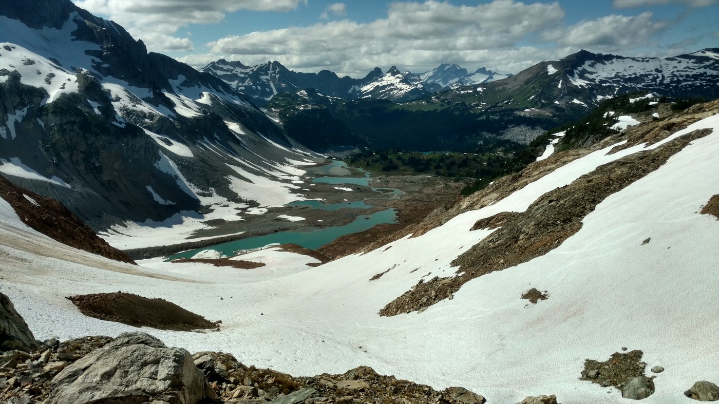
We continued up and over the glacier through Spider Gap. Most had spikes as it was suggested previously. I dont feel as though you needed them and they were basically extra weight but I did bring them. We then headed down Lyman Glacier and had to play "find the trail"
There really isnt a trail to follow as much as just head down to the lake and then once you start along side it you pick one up. Travel through here was time consuming due to the terrain. We then came to the detour. At the time we arrived the sign was in the middle of the trail held down with rocks. If for some reason you see a left turn with a yellow ribbon on it and no sign you better follow the yellow ribbons as some SOB moved the sign.
So shortly after the left turn and we encountered a stream/river where we needed to take our boots off to cross. It was pretty simple but the water was just below my shorts. Then we headed down the hill to the side of the boulders where there was a trail that came and went. After walking along the lower lake we found a campsite just before another creek where one might have to take off there boots again to cross. That one was a small shallow one but for some reason deep enough to need to take your shoes off.
We should have went a little further as there were better campsites but all was good. I am not sure what to say about the bugs. I never used bug spray the whole weekend but I dont recall many bug bites the first day or night. I think my friends used spray though.
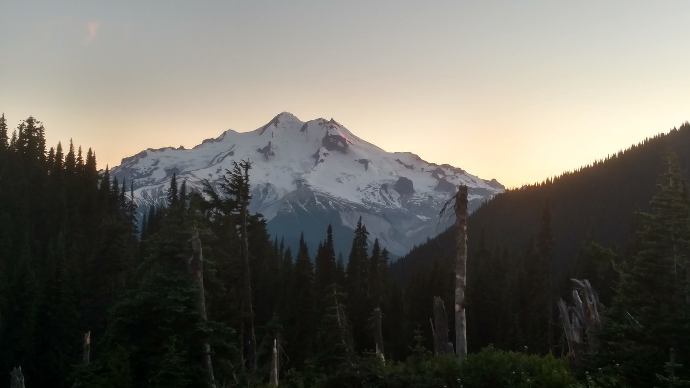
On Saturday we took off and headed for Flower Dome. The hike to Cloudy Pass was awesome. It was about a 800' gain from the campsite. There was some snow at the top still but none on the trail basically. We headed down and took the hikers shortcut despite the suggestion not to. There was no problem with this shortcut and it was passable without even touching snow.
We stopped for lunch at a viewpoint right about a mile after Suiattle Pass on the descent. This was toward the end of our 2000' foot decent. Then up again we went making a left on a trail that is easy to miss. Up and up we went on our 2000' gain. We reached what is called Middle Ridge and we couldnt stop for a second without the flies wanting to say hello. Now the 1000' drop and 1000' gain to end the day just past the Flower Dome turn at Buck Pass. Like previous reports there is one campsite with a view of Glacier but we headed down to one just below right next to the creek as we required water.
Over all up until the second night there were very few blow down and on the second day there were no water crossing that required removing ones boots. there was some that appeared to be tricky but even with a 50# pack all was well. Some I wouldnt want to cross if it was raining and the logs were wet.
One the last day we headed down from Buck Pass to complete our loop hike totaling about 36 miles. Yes, Image Lake would have been nice but we did pretty good for a two night and three day trip. One extra day and night would have been nice. The trail up to High Pass from Buck Pass looked incredible as well.
The last 11 miles were interesting. There was overgrown trail, blow downs and fire damage. This is not the way to start this loop in my opinion but a nice gradual descent to end the hike.
Overall it was a great backpacking trip and my first multi night one. My pack weighed 50#'s and I have some older stuff so not really light. This is an awesome journey and I didnt seem to have nearly as much problems as the woman who wrote the trip report last weekend. We did bump into a hiker who said he just found a phone so we let him know that there was a trip report where someone had lost one. What are the odds in all that wilderness that a phone is found and returned. This hike is a MUST do!! One last note, one of the people we passed asked us about water at Cloudy Pass as he said he had trouble finding some above 6000' We by then were at that elevation or below so just a heads up in that regard.
Comments
murphye2924 on Spider Gap - Buck Creek Pass Loop, Spider Meadow and Phelps Basin, Spider Gap, Lyman Lakes, Upper Lyman Lake
What kind of car did you take to the trail head? I have heard the road is rough and it is recommended to have high clearance vehicle. My car is a VW Golf. If my car can't make it to Trinity, any idea how many miles Phelps Creek trailhead is from the last decent maintained piece of road. I would be ok dropping my car before reaching the trailhead and adding extra miles hiking the rough road to the trailhead.
Posted by:
murphye2924 on Aug 01, 2018 07:05 PM
Road conditions
The part of the road that is rough it's actually more rugged is only the last two miles to the Phelps Creek trailhead. I have a Suburban. My friend had an Outback. The road to Trinity is fine it's one mile in another direction from Phelps Creek trailhead. the last two miles are rugged if you go slow and know how to drive you can get a golf up there as long as it doesn't have a low front end spoiler. There are some big rutts. It's all about taking your time. my Suburban does very very poorly in 2 wheel drive in the rain in on slippery surfaces and I didn't slip once. The last two miles again are the driver and just being comfortable. There is a section of the last bit that's Rocky as well. I would leave my car at Trinity and walk up the hill to start the hike if you're doing a loop. The last 10 miles are kind of uneventful coming down through Buck Creek. At this point you don't want to have to walk up the road. I hope that answered your question.
Posted by:
KonaHikes on Aug 01, 2018 08:19 PM
murphye2924 on Spider Gap - Buck Creek Pass Loop, Spider Meadow and Phelps Basin, Spider Gap, Lyman Lakes, Upper Lyman Lake
This was very helpful thank you
Posted by:
murphye2924 on Aug 03, 2018 10:44 AM