
First official day of spring break, and I wanted a hike that would distract me from thinking about school. Did I find it? 1000% yes.
I decided to try a loop hike, starting at North Chuckanut Mountain Trailhead. I've done some trails from this point, but not the loop I was attempting. My goal was to start out on the North Lost Lake Trail, then take the Ridge Trail (Lower, Middle, then High) to Cyrus Gates Overlook, where it meets the end of Cleator Rd. Instead of backtracking, I wanted to continue on the Rock Trail, then return on the Lost Lake Trail.
I parked at the trailhead and started hiking at 7:20am. There is a port-a-potty in the parking lot, and lots of space to park (though it was mostly full when I got back to the car). The trails are well-signed at most intersections, but it did help to have Alltrails, since a few spurs and other trails had no signage.
The first two miles are a good warmup, steep in some sections but not too steep. Slow and steady is the key. Definitely take time to look around - giant moss-covered trees, green shoots covering the ground, lots of water everywhere. So much life!
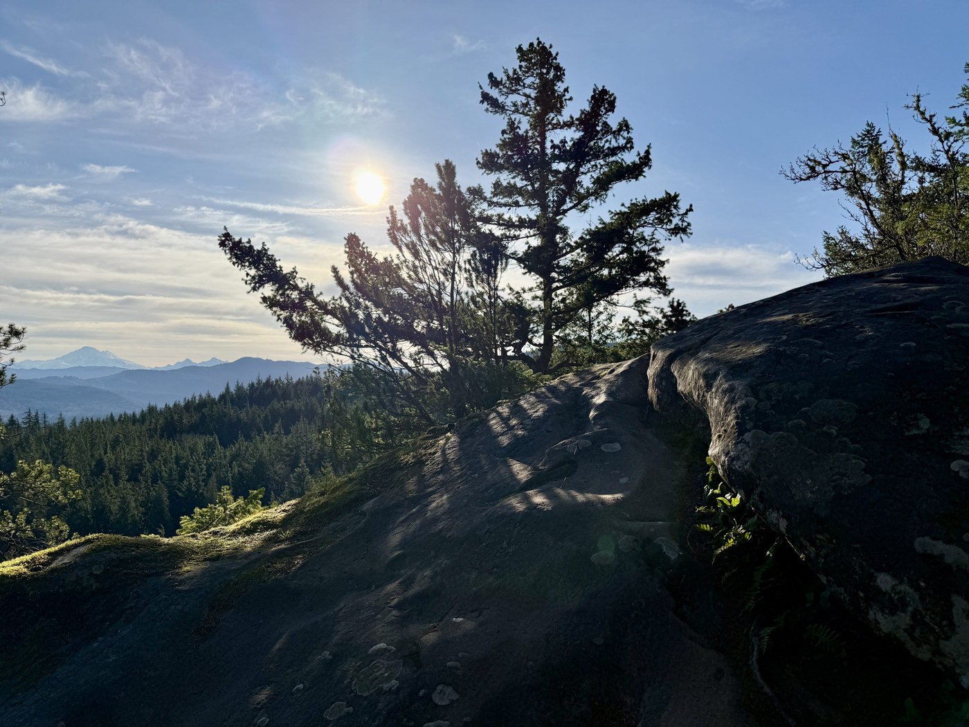
Just after two miles, the Ridge Trail splits off to the right. This Ridge Trail was the HIGHLIGHT of the entire hike - you are done with the worst elevation gain, and so the trail just meanders along the ridgeline. Want a view of Kulshan? You get MANY - and most of them have an abrupt cliff edge, so be careful, especially if you are hiking with kids or pets. Tired of Kulshan? Look to your right, eventually you get views of the Salish Sea and San Juan Islands. How lucky are we to live here, people?!!?!
The Ridge Trail definitely requires more mobility - at times you navigate boulders and walk on giant rock slabs. Other times you are climbing up roots, or doing a little route-finding. Some parts of the ridge trail would be much more challenging on a wet day - slippery rocks and muddy sections would have slowed me down a lot. But today it was dry and solid.
The Ridge Trail actually goes above the Cyrus Gates Overlook, so you can either walk on Cleator Road (a dirt road at this point), or you can come down a short, steep trail once you are parallel to the parking lot (like I did). There are bathrooms here, as well as some picnic tables and informational signs. There was one car in the lot. I think a lot of people start from this point when hiking in this area. I sat at a picnic table, hydrated, snacked, and enjoyed the view of the water. This was 5.4 miles from the trailhead.
Feeling like I still had a ways to go, I ventured onto the Rock Trail. It's only 1.2 miles, but it is steep - I'm glad I did this loop counter-clockwise, so I didn't have to come up all of the steps and steep switchbacks on this trail. This trail also has its own personality - sandstone cliffs that look like they belong on the beach, boulders strewn here and there, and lots of stairs. Huge shoutout to WTA and all the volunteers who blazed this trail, making a loop like this possible!
At the end of the Rock Trail, I turned left onto the South Lost Lake Trail (which became the North Lost Lake Trail once I was...wait for it...north of the lake). This is a pretty straightforward trail, you can really just get into the zone and just plow through the miles. There are some muddy patches, most are easy to navigate.
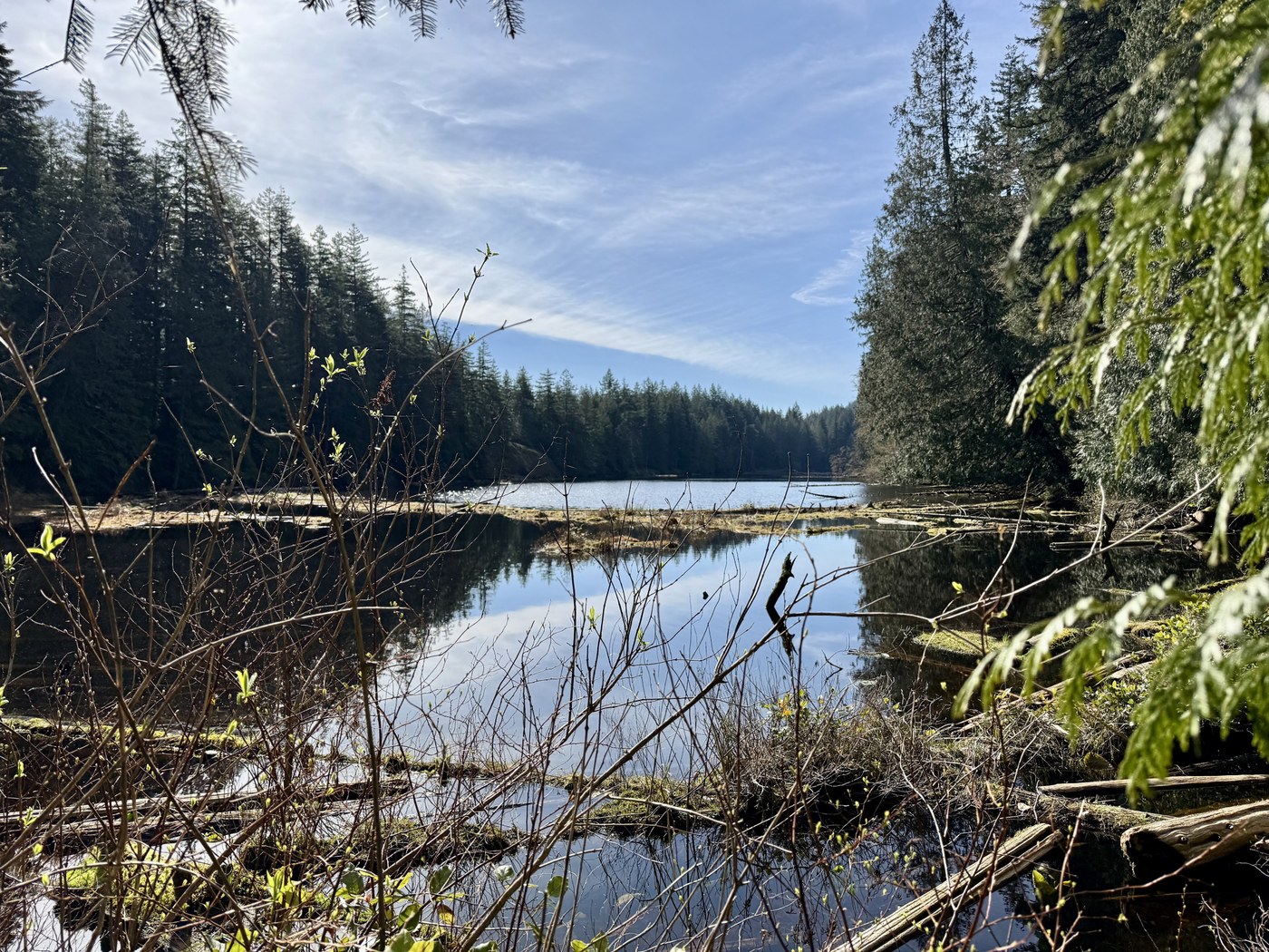
When I passed the lake, I attempted to get to the shore. I had visions of soaking my already-sore feet in the cold waters of Lost Lake. I took the spur trail (which is really muddy, with some "bridges" through the mud - step carefully!), but never really found an easy way to the shoreline. There is a probably a good one if you follow the marked trail all the way around the back side - I was just impatient and tried a shortcut to the closest end of the lake. I wound up pushing through tree branches and bushes, and almost soaking myself in bog water. I got close enough to get a decent photo, but I didn't ever stand on the shore. There's always next time, I guess.
Back on the trail, I headed back on the North Lost Lake Trail. This was a nice, gradual downhill, with the added bonus of a rowdy chorus of croaking frogs while passing some swampy areas. I passed the turnoff for the Ridge Trail at just before 10 miles.
The last two miles were not the most fun - my old-man feet and knees were staging protests. Eventually I made it back to the car in one piece, breathing a big sigh of relief.
This is a great hike on a sunny day - it's mostly shaded, I was in shorts and a t-shirt most of the time (if you don't like ferns occasionally slapping at your legs, you may want to wear pants). I wore trail runners, but having poles helped with some of the steeper sections and muddy sections.
I only heard traffic from Chuckanut and I-5 during those first few miles (and the same last few miles). I saw a few people at the start and at the end. Otherwise, for most of the hike, I felt like I was the only person on the planet. And as a guy who spends his days surrounded by 11-year-olds randomly blurting "6-7" that solitude was just what I needed :)
A total of 12.1 miles, 2450 feet elevation, I was on the trail for 4 hours 40 minutes. It was an epic morning, I was grateful to be out in the woods, surrounded by so much life.

Comments
Beautiful!!
Posted by:
dojtravels on Apr 06, 2026 06:56 PM
Sounds like a blast! Thanks for the excellent write up
Posted by:
hikethe100 on Apr 06, 2026 09:48 PM