

September 15, would have been my grandpa's 92nd birthday, and what a better way to celebrate him than by giving back to a trail (of many in the area) that we hiked together. My grandpa gave back to his community in so many ways, and now I give back to the hiking community by volunteering to keep the trails in good condition. Bonus, Rainier made an appearance today (grandpa must have known!)
The Road: Road 70 is paved all the way to the turnoff for 7030 (Which is not marked, but it is the first left turn after the shooting range). 7030 is not paved once you cross Greenwater River Bridge, shortly after the turn. The road winds and a few other roads, but if you follow the main tire marks on the road you'll be on the right one. After about 7.5 miles of gravel you'll see a parking area to the left of the road (if you continue the road dead ends). There are some larger potholes on the road, but nothing that even a sedan could do, just go slow. There are some steeper sections of the road, but not that bad. I’ve been on much worse roads.
The parking: I recommend parking diagonally in the small parking lot, there is enough room for 10 cars if parked correctly. Remember to leave room for emergency vehicles, just in case something happens.
The trail: The first part of the trail is flat along what used to be the road to the trailhead. It’s flat for the first .6 miles. You’ll then see a little border of rocks and a trail sign pointing towards the switchbacks. Here is where the real work starts! Unlike pre 2007 when there was a rope to help you up the rocks, it is now switchbacks. 15 tight steep switchbacks, with two very large steps (Which WTA is going to hopefully be addressing to make it less of a big step). After these switchbacks the trail is flat for a quick minute before it starts 8 more switchbacks which are steep but not as steep. From these 8 you may be able to see Mountain Goats to the west where they like to hang out. If you need a breather, take one, turn around and you’ll see Mt. Rainier (If it’s clear out). The last .4 miles of trail is less steep, it climbs only 200 feet incline, mostly closer to the lookout. Once you get out of the trees there is a short steep area then the lookout is in view! The last little climb to the deck of the lookout is also steep. The huckleberries were on their last little bit of life, mostly overripe if you ask me. And they are starting to turn their fall red color. Besides Mountain Goats near the trail, no other wildlife was seen all day. The trail itself is narrow in some spots, huckleberry is growing into the trail (About 8 years ago WTA brushed back a lot of huckleberry from the trail, but it is starting to grow in again). Some of the trail is ‘rutted’ from water (snow melt mostly) from rushing down the easiest path so there are some sections of the trail that are about 1 foot lower than the sides of the trail. Lots of social / animal trails, please leave no trace and stay on the trail. Speaking of leave no trace, if you need to use the bathroom, please dig a cat hole! One of our crew members dug one, to bury human waste he found while a little off trail gathering material that we would need for the work.Other people should not come across your waste and TP!
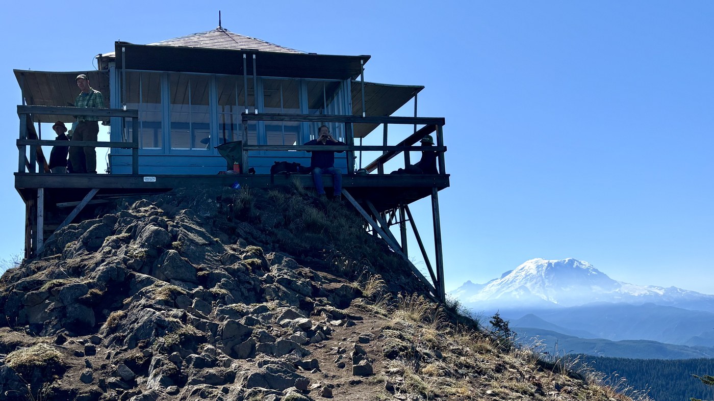
The lookout: It was still ‘open’ for the summer, meaning you could look into it, but the door was locked so you cannot go inside.The mountain was a little foggy at first but then the clouds cleared and it was a perfect bluebird day for most of the day. From the backside of the lookout you can see the Stewart range, and some of the smoke from the Sugarloaf fire burning near Leavenworth. You can also see powerlines, along with other FS roads. On the main side of the lookout is Rainier and all her glory (again when it’s clear). As the day progressed smoke from the Wildcat Fire (bumping lake) came in and kind of obscured the view. From the panorama at the lookout you can see the patchwork of logging that takes place on our national forest. Always makes me smile when I see those patchworks of different levels of trees. Signs of a healthy managed forest.
Our Work: Our crew was helping to make some of the trail easier to walk on, but removing rock with feather wedges, and near the end of the switchbacks placing rocks to help slow the water down as it comes down the trail.
Tips for the trail: There are no restrooms, or water on this trail, please bring enough water, most of the trail is exposed and can get warm. If you need to use the bathroom please follow Leave Not Trace Principles. This is a short, steep, but rewarding hike - trekking poles help not only with the up, but the coming down as well. It is dry and dusty, take your time coming down so you don’t lose your footing on the switchbacks. Additionally right now is hunting season, we did see some hunters when we got to the trailhead at 8 in the morning, so be aware, wear orange, and if you have a dog, keep them on leash.
Until next time, Happy Trails!

Comments