
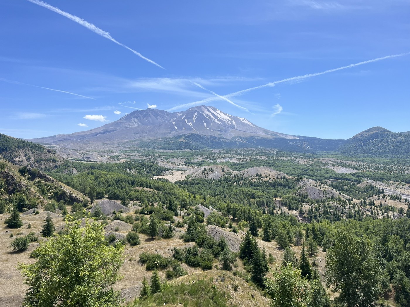
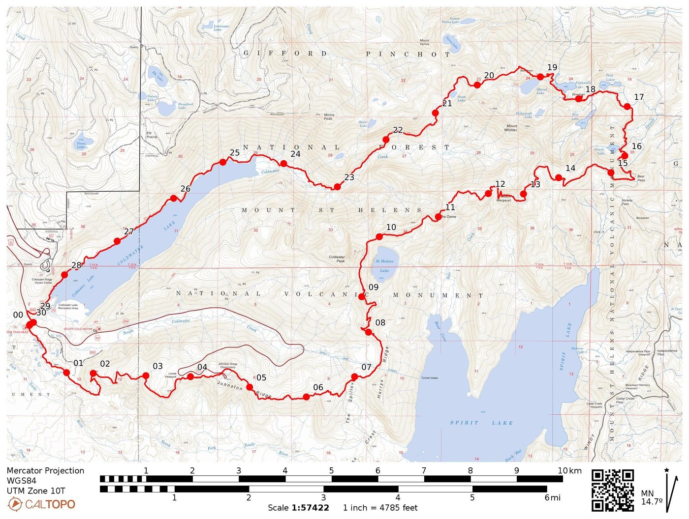
Kind of a major "why haven't I done this before" moment with the Mt. Margaret Backcountry this weekend. Ended up having a lovely 30mi and 7,500ft gain loop around the Mt. Margaret Backcountry via the Boundary Trail starting from Coldwater Lakes TH.
Big thanks to the previous trip reports for the route idea and the much needed trail maintenance this season. There's a lot to cover in such a small area so I'll break it down piece-by-piece. I've also attached an image of the map of the loop to the TR.
Dogs?
- WTA, AllTrails, and several other sources (including the Visitor Center) all say dogs are prohibited in the monument's restricted area
- I've heard mixed things, so I called in and was directed to an area map revised in 2022
- A lot of trail signage will still be mixed about dogs/no dogs
- Definitely still not allowed at the Observatory
- If I'm in the wrong on this, I apologize and I condemn myself to pickup 5 poop bags off Lake 22's trail
Coldwater Lake TH to Johnston Ridge Observatory
- Could've started this at Hummocks TH as well, but figured I'd get the road walk out of the way first
- Very pleasant and well graded trail up to the Observatory with straight in-your-face views of MSH
- Carry a lot of water - this section is extremely exposed and the nearest water even close to the trail is in 8 miles
Johnston Ridge Observatory to Bear Pass
- Ignoring my own advice above, I was running pretty low on water...but found a somewhat-dependable trickle of a creek just down the Truman Trail about 0.1 of a mile (around 8mi from Hummock TH)
- Otherwise, next dependable water is Grizzly Lake...but this time of year, I found water melting from snow patches and reserves from just before Mt. Margaret onwards (Bear Camp has a strong flow right now)
- I've eaten a lot of berries before, but the strawberries right after the Coldwater Peak turnoff might be the best berries I've ever had in my entire life (and they lasted for miles too)
- There's a bit of climbing here, but the trail is in excellent condition given that the road to it's main TH has been washed out for two years
Bear Pass to Snow Lake
- This section is a little rough - salmonberry bushes frequently topped out over me
- It wasn't horrendous, but the really overgrown sections between Bear Pass and Panhandle Lake really did cut down on speed
- I got a permit for Panhandle and it was lovely - quiet with a slight breeze, trout jumping, and almost no bugs?
Snow Lake to Coldwater Lake TH
- Still a bit brushy, but not nearly as bad as after Bear Pass
- Previous reports in July of this year mention some less-than-ideal snow traverses: pleased to say these are all gone now
- The one up by the Shovel Lake turnoff is still there, but an easy shimmy up and around it
- The big unknown this section were the washouts as previous TRs had described
- There were really two of note, only one of consequence (photo)
- Most should be able to get around these...worst come to worst, could dig the steps deeper with a trowel or something
- Every single type of berry! Salmonberry, mountain & red huckleberry, strawberry, European blackberry, thimbleberries and likely more I didn't spot
- Trail conditions immediately improve just before the Coldwater Trail intersection
And if you're interested in the history of the area (specifically with the 1980 eruption), this Google map is a great resource to save offline. Has a lot of historic locations of places like Coldwater 2.


Comments
Super helpful, thanks so much! Did you see a lot of pups on trail? Planning to bring mine just for a day hike.
Posted by:
Raeandkhali on Aug 07, 2025 07:56 PM
Of course. And one or two closer on the Coldwater Lake side of the trail. But none at all back in the loop.
Posted by:
kj15 on Aug 07, 2025 09:21 PM