
Boundary trail is in great condition. (They’re even starting to fix the boardwalks at the long-neglected Rainforest Loop at the start!)
Waterfall crossing is doable, but be cautious and don’t trust that the rocks are stable. If it was below freezing and there was rime ice on rocks around the falls, I would have turned back.
Noticeable, patchy snow after 4000’ but only one short jaunt through a proper snowfield shortly (<1/4 mi) before the junction with Florence Peak trail. The person who tried yesterday gave up here, either from time or didn’t want to deal with snow.
The Florence Peak trail was surprisingly straightforward to follow, just follow the crest of the ridge. Not more than 5” of snow and patchy. Occasional steep patches with slippery shattered ice accumulated from above: Warm sun was making frozen ice bombs rain out of the noble firs- wish I had brought a helmet, and briefly considered turning back with 4” ice chunks plummeting here and there. I finally put on micro spikes here.
Straightforward up to the summit block. Only a couple short snowfields where I postholed, so I didn’t use my snowshoes.
Then the last push up Florence Peak was super steep, super hard re-frozen snow, very different from any I had seen yet today. I managed it with micro spikes and a trekking pole, but would have felt better with an ice axe and crampons. Very hard to kick steps, and angle must have been 60deg or more at times? Not crazy exposure, but would have been very hard to arrest a fall and you’d slide enough to risk injury. I’m curious what this looks like in the summer.
I stopped below the last ~20’ vertical before the summit, as you get the views and don’t have to scramble on sketchy icy rock.
Overall gps distance was about 5mi (with some occasionally route finding/snow detours). The janky sign at the beginning of the boundary trail is misleading- it says 1.3 to waterfall and 3.0 to Alki Crest. I had 1.8 to the waterfall and 3.6 to the start of Florence Peak trail. (All the maps I’ve seen show Alki Crest being 0.7 mi SE of Florence. Does it really encompass the whole ridge including Florence peak?)
My gps was 5.0 mi trailhead to (near) summit, with 3700’ ascent. 3h50m up, 2h40m down.
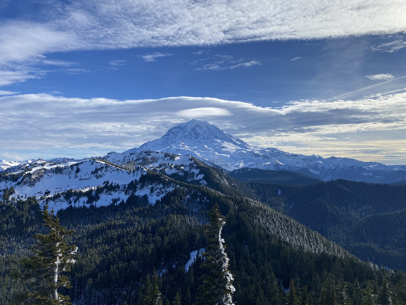
If you’re wondering about long distance views on this route, there are precisely none to speak of until you’re just shy of the summit (it’s forested the whole way). I can’t speak to what it’s like further along the ridge past Florence Peak.
The views from just shy of the summit were spectacular today!
(This is my first trip report, please leave constructive feedback)


Comments
Excellent trail data. Look forward to seeing more reports.
Posted by:
Ups n Downs on Jan 15, 2025 06:55 AM
Welcome to WTA and thank you for the report! This is a favorite of mine in the park. It's fun in all seasons, but the winter is extra spicy. Glad you survived the waterfall crossing- so sketchy. Always. Great report and info!
Posted by:
mam013 on Jan 15, 2025 07:57 AM
Great report and good, illustrative photos! Welcome!
Posted by:
Anna Roth on Jan 17, 2025 10:42 AM
Yes, great review. I went today and brought my ice axe because of your review. I definitely needed it on the last couple hundred feet to the false summit. It had frozen solid into a nice smooth slide overnight and I was there early, before the sun hit it. Had I not brought my axe, I wouldn't have attempted it and would have missed out on the views.
Posted by:
NeighbourHiker on Jan 20, 2025 06:38 PM