

ROUTE: Obstruction Pass TH -> Lillian Ridge Way Trail -> Grand Valley down past Gladys, Moose, and Grand Lakes -> Badger Valley Trail
Route was somewhere between 10 and 12 miles (depending on which device you trust most) with ~3,500 elevation gain.
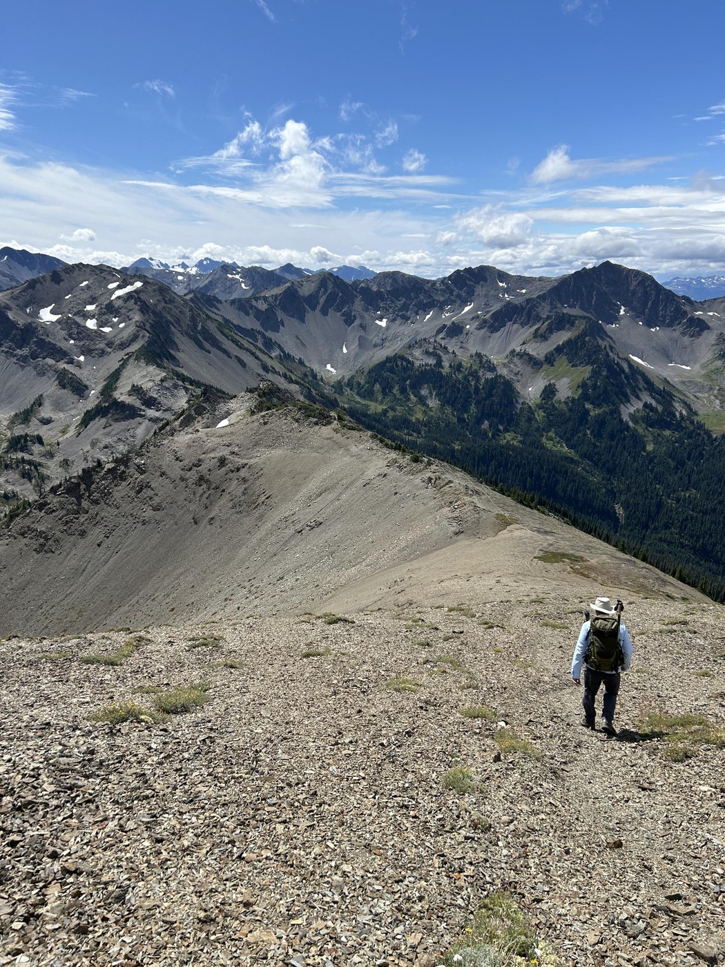
Lillian Ridge Way Trail: This area wasn't too bad because there had been recent rain, but I can see that scree being a real pain to navigate on a dry day. This route would absolutely not be suitable for backpackers or for the inexperienced. It took us almost a full hour to do the trickiest mile (usually I'm around 28-35 minute miles). Views were stellar.
Grand Valley and lakes: very easy stroll through this section, and absolutely beautiful. Marmots, lakes, deer, happiness.
Badger Valley: a nice change into forest punctuated by a few meadows. Lots of downhill had me concerned because I knew we'd have to go back up again, but the uphill was gradual enough to be perfectly fine. I'd recommend doing this route back to the TH instead of the trail that goes from Grand Lake. The Grand Lake trail is more exposed, less scenic, and steeper.
Bugs weren't bad at all.
Wildflowers are almost spent for the season but there were still plenty, along with bumblebees and butterflies. I saw three very young marmots, which was a rare treat. They were only about the size of large squirrels. There were plenty of adult marmots too.
This would be a great place to go backpacking if you want amazing views, lakes, and wildlife without having to work all *that* hard.
If you're sensitive to altitude you will need time to acclimate.
The following is quoted from a trip report by Ancient Ambler because it identifies many of the specifics of the Lillian Ridge Way Trail:
"Took the ridge trail toward Grand Valley, but left the main trail at about 6400 ft elevation for the Lillian Ridge way trail at the point where the Grand Valley trail heads east toward the many switchbacks down toward Grand Lake. The Lillian Ridge way trail is easy to follow for the most part, but there are some stretches that involve rock scrambling, descending or ascending steep scree slopes and route finding, so this is not a trail for neophyte hikers.
The way trail is basically the remnants of a long-abandoned trail that led along the top of Lillian Ridge on the west side of Grand Valley toward the headwaters of the Lillian River, on to the Lillian Lakes basin, over the divide west of McCartney Peak and then high along the ridge running on the north side of the Lost River to Cameron Pass. From its departure at ca. 6400 ft from the Grand Valley trail, the way trail heads south along the ridge, past peaks 6530, 6486, and along the west shoulder of peak 6580 (USGS map as reference). From the west flank of peak 6580, the permanent snow field on the north face of Moose Mountain (6753 ft) is visible, as is an obvious, sawtooth ridge running southwesterly from peak 6580 to peak 6585.
The route crosses this sawtooth ridge to about its midpoint, where the rock has a reddish color that you can see when you reach that point. The route then descends a steep unstable scree shute on the south side (Grand Valley side) of the sawtooth ridge. (If you try to descend the sawtooth ridge too soon, there are some perilously steep shutes, so keep going along the ridge till you come to the feasible shute.) Once you reach the bottom of the shute, the route heads southwesterly, not far from the base of the sawtooth ridge. You should see a faint boot track that heads up the scree to the low point between peak 6585 and Moose Mountain (6753).
From this low point, the trail ascends the ridge to the summit of Moose Mountain, providing superb views in every direction. A short walk to the east of the summit will show you all of Grand Valley and its three lakes, and a fine view of Grand Pass.
Back at the summit, looking southwest you have a rare view of the two Lillian Lakes lying just to the north and a bit west of McCartney Peak (6784), and to the south, the summit of Mt. Anderson is visible. To the west, there are great views of Olympus, the Bailey Range and a multitude of other mountains .
...Then headed south down Moose Mountain to the low saddle between Grand Valley and the Lillian River drainage, where time was spent in preparation for a future trip looking for remnants of the old trail to Lillian Basin and Lillian Lakes. Then headed down the east side of the saddle and intercepted the Grand Valley trail, walking out past Gladys Lake, Moose Lake, Grand Lake...

Comments