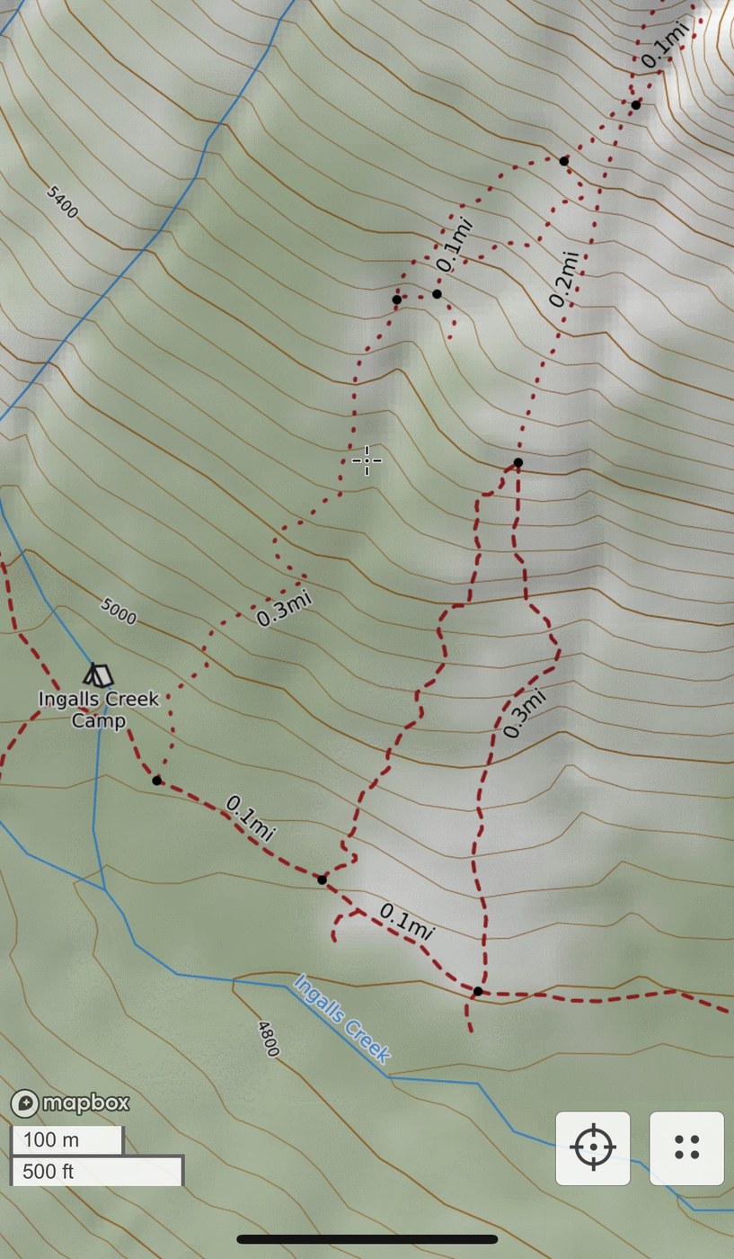
Climbed via Cascadian Couloir. This is a tough scramble that sounds like it varies a lot with conditions. I'm an experienced scrambler but not a technical climber - I was fine with only poles in no snow, but was up against the edge of my comfort level.
APPROACH: There are three entrances to the couloir marked on Caltopo (see pic). I took the easternmost one going up, which was bushwhacky to start and then a long slog straight up loose sand. On the way back down, I happened on the westernmost (dotted rather than dashed) route and was thrilled to discover that it's a beautiful, seemingly well-maintained trail with switchbacks and shade. Definitely take this way up - the entrance was marked with a large cairn, and it's a clear trail right from the beginning, no bushwhacking required, making the first thousand feet much more pleasant. Eventually it dumps you in the couloir and then it's a straightforward but sloggy climb like other reports say. Leads up to an obvious crossover on the right to a wider, sandier couloir around 7600 feet. Get to the top of that one on the right side, then bear up and left towards the snowfield. Poles felt essential, helmet would have been smart, and definitely wished I'd brought gaiters.
SNOWFIELD: Getting over the rib below the false summit felt like the sketchiest part to me. This time of year the permanent snowfield (which looks like it may be less permanent as time goes on) is in two pieces. Getting past the lower one is just more sand climbing. Getting past the second one required scrambling the rocks on the left side for about 50 feet, which felt class 3 but steep and sandy/slippery especially at the beginning. There are probably multiple ways to do it, but the only route that seemed to go for me was sort of a backwards C - started on the left side of the scramble-able rock maybe 15 feet from the snow, worked my way right towards the snowfield going up, and then cut sharply left again near the top, following cairns, to make the rib below the false summit right about 9000 ft.
SUMMIT SCRAMBLE: Easier than it looked from the rib. The guidance in the August 7th report was helpful: the route mostly has sand, and stay lower off the ridge until right up near the top. There were lots of cairns, though a few of them seemed to be leading towards another approach from lower down. This part was pretty fun and generally not too exposed. There were two class 4/5 moves I couldn't see a way around - one to get onto the summit block on the right/east side, and one pretty close to it. They were both ladder-like chutes, about 10-15 feet and not otherwise exposed, felt pretty easy but it helped to be tall. Views at the top are incredible.
DESCENT: I was not looking forward to it, especially getting back down beside the snowfield, but fortunately everything felt easier on the way down. As other reports have said, it's easy to cruise on sand down past the crossover to the original couloir, so work towards the right earlier than you think, basically as soon as the trees start around 7800 ft.
No water after leaving Ingalls (there's a stream that goes beside the approach path for a while but it was covered by thick brush) so stock up. I melted a bit of snow at the snowfield but there wasn't a real flow.


Comments
Dmkr on Mount Stuart
Thank you for the detailed trip. It really helps with your dots on caltopo map and the rib near the summit scramble.
Do you think you can post the gpx file or the route from caltopo
Thank you and much appreciated.
Posted by:
Dmkr on Aug 15, 2024 10:45 PM
dca2dc on Mount Stuart
Can only post 4 pics, but there are lots of full maps and files at https://www.peakbagger.com/Peak.aspx?pid=2182
Not all the routes described there are this one but looks like most of the reports are this route.
Good photos in the Beckey Cascade Alpine Guide book 1 also.
Posted by:
dca2dc on Aug 16, 2024 06:28 AM
Dmkr on Mount Stuart
Thank you so much
Posted by:
Dmkr on Aug 16, 2024 05:29 PM