
I'm confused by the conflicts in tone on the main page for this hike ("even veteran hikers have a hard time following it"), the 9/11/22 report ("overgrown for about 2.5 miles with blueberry bushes") and the more up-beat 9/3/22 report ("The road up the Wynoochee River is cleared of downed trees, and the trail is in surprisingly good shape considering last winter. There's actually been work done on the first mile or so too! the old road bed has been brushed, and the bypass around the landslide has been rebuilt to be more stable. Once on the actual trail, downed trees have been made passable and the trailside has been brushed. For a bit. It's still a root-and-rock trail (part of its charm) and it's pretty brushy past the recent work, but I'll take it.")
I did this trail as a backpacking trip in 2020 with 5 year old twins and a 7 year old. It was a great relatively short and low-traffic trail to a nice lake. Shorter than other approaches, and available earlier in the season. I think I went around July 2nd. The trail from the lake to Six Ridge Pass still had steep snow on it at the time. When I went, I didn't have trouble following the trail. I probably had a Caltopo map loaded on my phone. I did talk to someone who had bushwhacked instead of taking the trail. I'm not sure if they did that intentionally or just weren't that great at using a gps. I think they tried to avoid some of the elevation loss and gain between Wynoochee Pass and the flatter section of the Sundown Lake Trail.
I suppose brush can grow fast, but it's hard for me to imagine how in just 2 years it could degrade so much that the description on the main page could have been updated to read "even veteran hikers have a hard time following it."
2 more years have passed since the last trip report, and the trail has probably gotten brushier. Still, I don't think it's time to write off this hike just yet. If you're the type of person who likes to try out the less-traveled obscure trails, this seems like a good candidate. Just leave a little extra time for navigation and dealing with brush. The 9/15/21 report has a good list of hazards to consider, though the 9/3/22 report suggests improvement on the washout. I'm tempted to revisit this one, but with the drive time and upcoming commitments it could be a while be I can get there.
If there's a short list of trails to work on, this one should be on the list.
The lake is in Olympic National Park, so if you camp there you should have a permit. You can reserve these online and print them out yourself, so no need to stop at a ranger station.

Comments
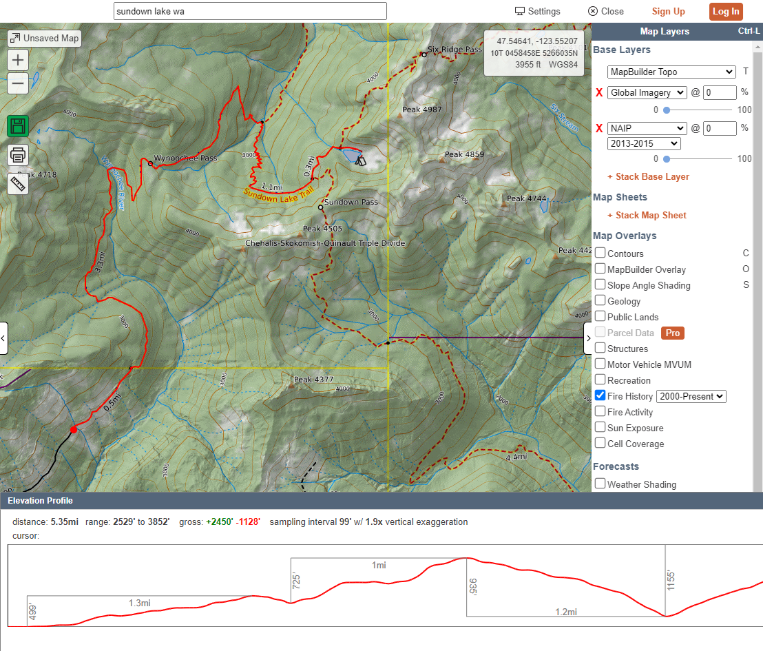
The problem here seems to be in the name itself; The "Sundown Lake Trail" labeled on the map shown above is not the "Sundown Lake Way Trail" (nor is it even the Sundown Lake Trail). In fact, the trail shown is the Wynoochee Pass Trail (completely separate from Sundown Lake or Sundown Lake Way Trails). That trail is a tough hike but it's easily followable.
The Sundown Lake Way Trail connects Wynoochee Pass to Sundown Lake by a fading path that is not shown here. (Caltopo does not show it either). The only map I know that shows the old way trail is the Custom Correct, and it was only ever a faint dotted line at that. Not sure about Green Trails.
In summary, the Sundown Lake area is still accessible by Wynoochee Pass (must drop lots of elevation and regain) and by Sundown Pass (steep gain from S. Fork Skok). You can also get there over Six Ridge. Some hardy folks might be able to climb out of the Graves Creek drainage but recent trip reports sound horrible.
Parties familiar with the old way path were unable to locate it in July of 2022 and had to follow the Wynoochee Pass trail down to where it meets the Graves Creek Trail, adding mileage and lots more elevation.
Some cleanup might be needed on the various "Sundown" pages here. Thanks for pointing out the disparity.
Posted by:
SpruceMoose on Jul 03, 2024 09:29 AM
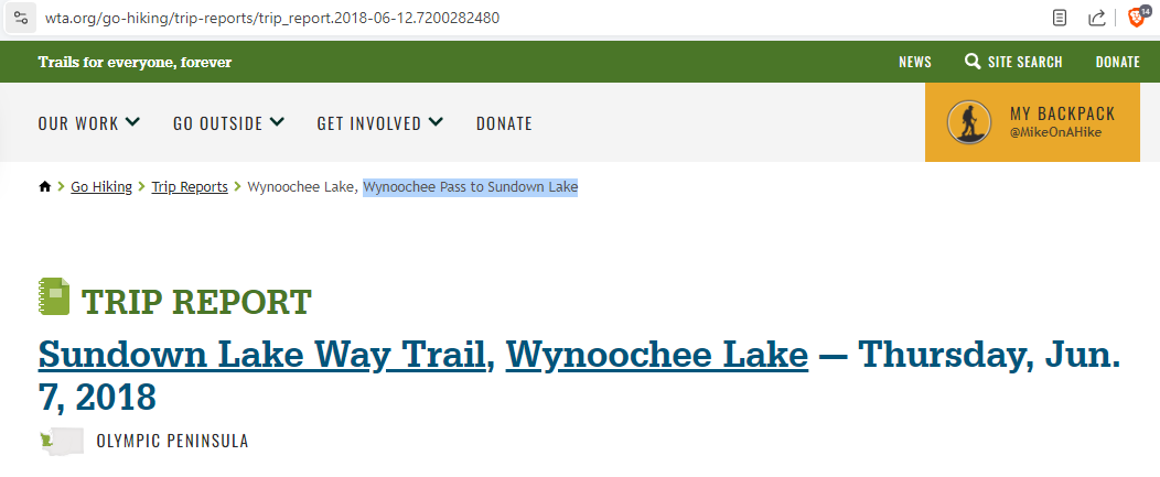
Excellent point about the naming issue. I wonder if things were right in the past and then something got changed incorrectly. On the Hike Finder map, the entry for "Sundown Lake Way Trail" shows up where the "Wynoochee Pass Trail" should be. Additionally, old trip reports have contradictory information about whether they're discussing "Sundown Lake Way Trail" or "Wynoochee Pass to Sundown Lake"
I'll attach some new screenshots with these details.
Posted by:
MikeOnAHike on Jul 03, 2024 12:41 PM
I'm late to the discussion, but you're absolutely right about the naming issues. WTA has changed the names of the trails here, and it has added a lot of confusion. This hike used to be labeled Wynoochee Pass Trail, but they changed it to Sundown Lake Way Trail, which is silly, because most of the trip reports were about the Pass, or if they continued on to the lake, most people did the whole down-and-up to Graves Creek, *not* the Way Trail.
When I hiked Colonel Bob back in 2021, I shared the top with a couple of old timers who were quite familiar with the Sundown Lake Way Trail and had done some work on it recently (recent to 2021). I had tried to find the way trail previously without luck, so I listened intently as they described it. I haven't had the chance to go back to look for it since, but I will.
Not sure who makes the naming/editing decisions at WTA, but they have made changes that mess up this whole area, including Wynoochee Pass/Sundown Lake, Discovery Peak, Discovery Lake and Anderson Butte (the one by Wynoochee Lake, not the one in the North Cascades).
Posted by:
Sabbaru on Dec 31, 2024 09:47 AM