TL;DR: This trail is in “adventurous” shape right now, get out there soon if you want to see the very unusual brown Trout Lake!
Our group of seven determined hikers visited West Fork Foss Lakes yesterday in search of waterfalls. And wow, we were not disappointed. The lakes and waterfalls are amazing right now. However, what was unanticipated and even more awe-inspiring was the huge debris flow that crashed down the mountainside, washing out a short section of trail and turning Trout Lake a rich brown.
ROAD AND TH: The road is in great shape. Some potholes here and there, but no problem for any car. The bathroom at the trailhead is open and stocked. Our two cars were the only ones at the trailhead in the morning, and one other party of two passed us going up near Copper Lake. A very peaceful hike for a popular trail.
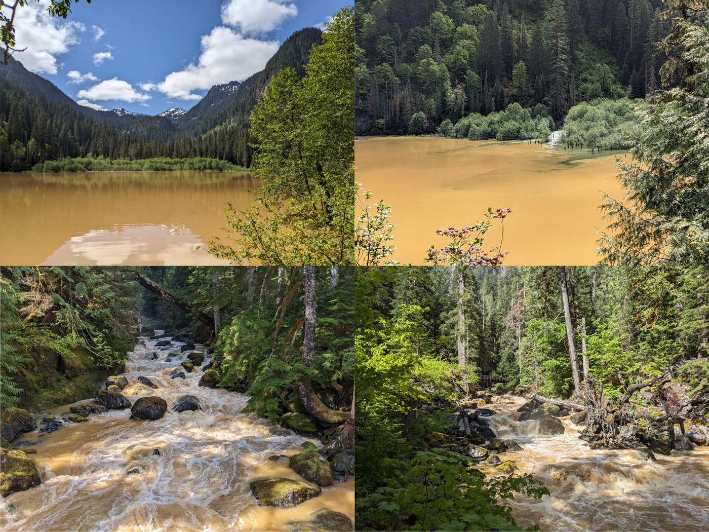
TROUT LAKE: Upon our arrival at Trout Lake, we were astounded by what we saw. The water is a mocha brown color. Our initial theory was that this was caused by extra forceful runoff from the storms earlier this week - see below for what really happened! There is no snow at Trout Lake, and the camp sites seemed dry enough. There are lots of nice wildflowers along the way, though the trilliums are mostly done. Lush ferns are everywhere. I’m not sure I’d want to filter water from the lake right now, but there are plenty of small side streams above the lake you can get clear water from.
The West Fork Foss River has the same brown color right now - it’s quite the sight from the bridge.
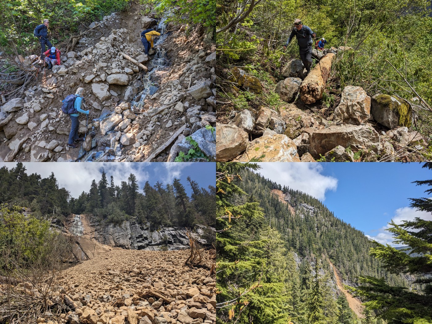
DEBRIS FLOW: As we ascended the switchbacks above Trout Lake, we eventually figured out the reason for the brown lake and river. At about 3100’, the trail crosses a small seasonal stream. This stream was the channel for a debris flow that started about 1000’ up the mountainside from where the trail crosses it. A huge chunk of the ridge top gave way and (presumably) thundered down the mountain, throwing mud and huge boulders down into Copper Creek. At one point, the flow went over a large cliff, leaving a fan-tail of rock below and just missing one of the trail switchbacks. Some of the large boulders landed in the middle of the trail, and you can see the path of destruction wrought by the rocks as they careened down the slope.
Crossing the debris flow path over the trail is a bit sketchy, but it seems stable enough for now, and will likely get more stable as things dry out a bit. I moved many of the loose rocks down into the creek to make the crossing safer, but more work will need to be done here with some real trail tools to put in a better, flatter route. For now, I recommend the “low route” which descends about 10’ from the trail level to the creek, then back up the other side. The mud can be slippery, so poles will help and you may want to kick in some steps along the way.
As you climb up toward Lake Malachite and Copper Lake, peer to the north and you’ll get a great overview of the debris flow.
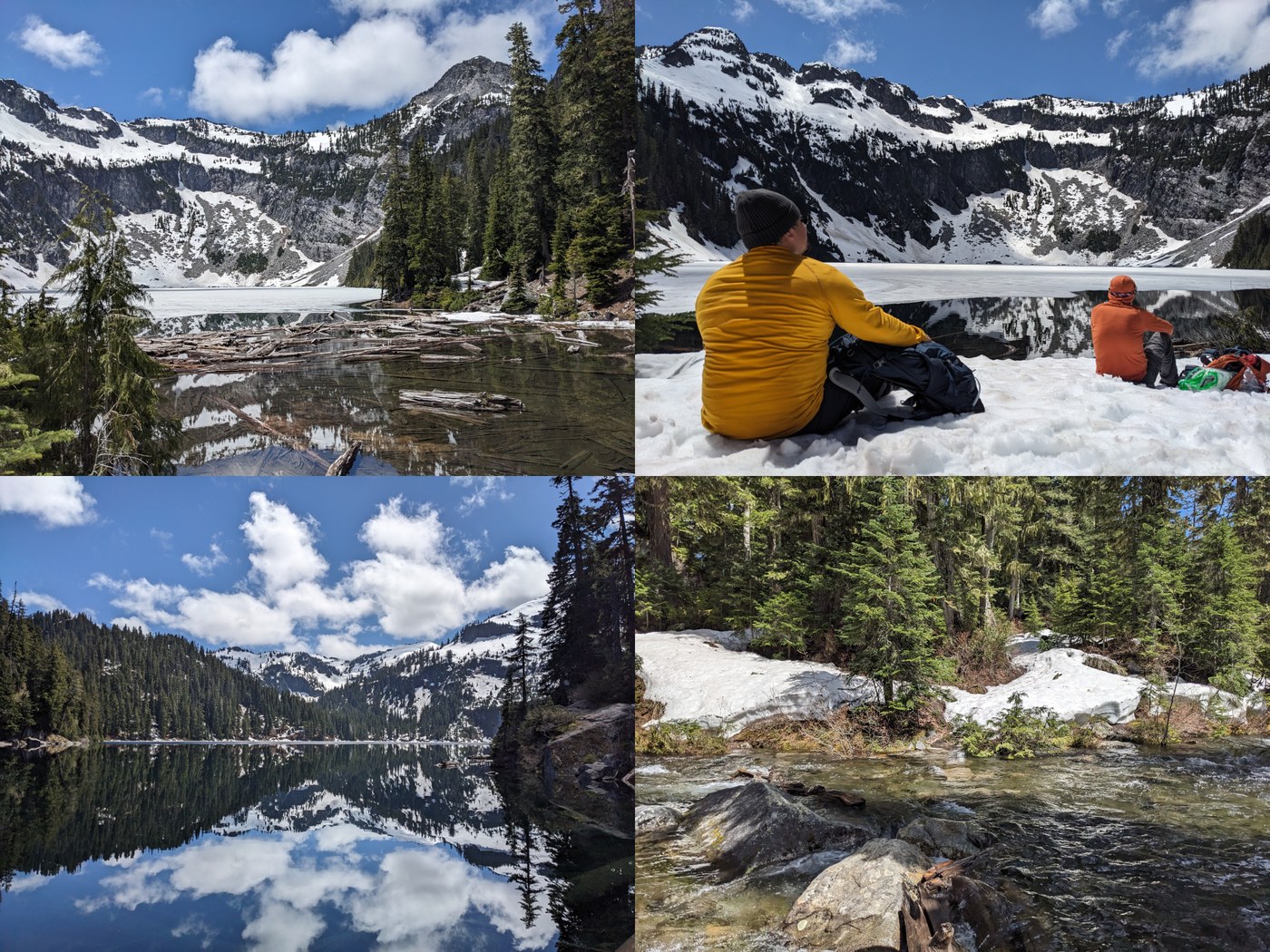
LAKE MALACHITE: Malachite is still mostly covered in a layer of ice, but will probably be melted out in a week or less. The surrounding cliffs and peaks are still very snowy, making for a fantastic backdrop. Getting up the rough bootpath to the lake is a bit dicey right now, due to a few places with quite a lot of snow - some members of our party chose to stay below. The main problem is post-holing in the rocky sections of the trail near the top. The snow is 6-7’ deep over the trail in the flats at the lake. Probably 75% of the trail is fully melted out, so the snow wasn’t a huge problem.
COPPER LAKE: Copper Lake is 100% melted out. The views are gorgeous right now with most surrounding peaks still covered in snow. Some of the forest around is melted out, but much of the surrounding terrain is still covered in several feet of snow. The large campsite on the west side of the lake is melted out. From this site, you can hear the roar of waterfalls on the southwest side of the lake.. We couldn’t get to the east side where the trail continues, but it looked more snowy. There is some snow on the trail between the Malachite Junction and the Copper Lake outlet, but it’s all pretty flat and easy. I went about halfway across the logjam for some views, but getting all the way across the logjam didn’t look doable now, since too many of the logs are floating.
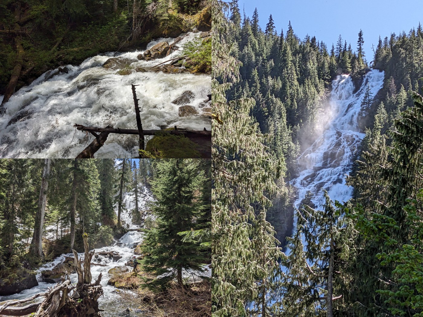
WATERFALLS: All the falls were roaring on our hike. Keep an eye out for the large waterfall that drains Panorama Lake (and other areas) high to your right before the river crossing. The river at the crossing is impressive as always, but bizarre with muddy brown water. Copper Falls is quite impressive, but Malachite Falls steals the show on this part of the trail. It’s hard to get a complete view of it, but from various places you will see the bottom and top, and hear the roar from a distance.
I would say the best waterfall was Copper Lake Falls, which is just below the outlet of Copper Lake. You can get up close and personal with this one, since there is a trail switchback right next to it, in the basin before you reach the Lake Malachite junction.
WATER CROSSINGS: The trail is as wet as I’ve ever seen it. Many parts of the trail between Trout Lake and the Malachite junction had running or standing water, no doubt the still-draining result of the storms earlier this week. This should probably be much better in a few days. The actual water crossings were not an issue, especially with poles and waterproof boots.
The one exception is the crossing of the outlet at Copper Lake, for the continuing trail on to Little Heart Lake. The rocks are fine most of the way across, but for the last 12’ or so all the rocks are submerged by a few inches. If your boots are waterproof and high enough, you might be able to do it while keeping dry feet, but realistically, I think this is a ford right now.
BLOWDOWNS / BRUSH: There are two blowdowns on the trail - one in the first half mile, another just before the bridge over Malachite Creek, both are easy. A large log has been knocked onto the trail near the debris flow, along with a series of medium to very large boulders. This area is a pain to scramble over, but safe enough. The brush on the trail is the worst in the switchbacks along Copper Falls - mainly encroaching vine maple. The lower part of the trail up to and just past Trout Lake is nicely brushed out.
SNOW: As mentioned above, there is snow near the outlet of Lake Malachite, in the basin above Malachite Falls, and around Copper Lake. Some of it is still quite deep, so watch out for post-holing around trees and big rocks. There are not many places with water running under the snow, nor any steep places that still have snow, so nothing too hazardous.
GEAR: We had spikes but never took them out of our packs. Poles were very helpful for the crossing the streams and debris flow, and just in general for the rougher sections of the trail. Waterproof boots were essential on our trip - without these you are probably going to be hiking in wet socks for most of the day.
STATS: Our visit to Copper and Malachite was probably about 9.5 miles with roughly 2700’ of elevation gain. It took us 8.5 hours, with liberal stops for photos, snacks, and scenic exploration.


Comments
Wow, that mud flow is really something. Any idea when it happened? It will take some work to reestablish the trail.
Posted by:
Maddy on Jun 06, 2024 05:52 PM
I'm pretty sure it happened some time during the big storms this week, Sunday - Tuesday. The area probably got about 3-5" of rain during those three days. Also, some folks have said that the lake was clear on Memorial Day.
The actual washout of the trail isn't too wide - maybe about 20 feet. I bet two or three people with shovels and grub hoes could make it into a pretty decent crossing in a few hours. All the rocks where the trail crosses are pretty small, so it'd mostly be digging in the mud and moving smallish rocks around. I am sure it would be a little easier once the mud has had a chance to dry out a bit.
Posted by:
ALW Hiker on Jun 06, 2024 06:00 PM
We live on the Foss river. I think we started noticing the brown river on Monday. We wondered why it was the color of really creamy coffee. Thanks for the write up. Time to go take a look for ourselves!
Posted by:
nmarment on Jun 06, 2024 08:21 PM
That just invited a bunch of people to swarm to this area and over run it.
Posted by:
Traillesstraveled on Jun 11, 2024 05:59 AM
This website may not be a good fit for you
Posted by:
Maddy on Jun 11, 2024 06:25 AM
Or you
Posted by:
Traillesstraveled on Feb 03, 2025 06:46 AM