
Nice two night trip with the first at the Lookout Mountain Lookout & the second at Monogram Lake.
We were originally planning on doing the Thornton Lakes & Trapper's Peak, but decided to try the slightly more ambitious hike to Monogram Lake after comparing the write-ups in the Ira Spring guidebook. We were permitted for two nights at Monogram, but as we began our ascent up the Lookout Mountain Trail, we encountered a pair of hikers descending who had spent the night at the lookout & advised us it was open. The Lookout is located on USFS land, so unlike Monogram Lake (which is in the North Cascades National Park), the lookout is first-come, first-served with no permit required, so we decided again to change plans & go for the lookout for the first night.
The trail climbs pretty steadily from the parking lot, with consistent switchbacks on a well established trail. Along the lower section, we found the red huckleberries were ripe & tasty. Mosquitoes & biting flies became prevalent after about a mile and a half, and shortly thereafter, we encountered a brushy section peppered with stinging nettles. Pants or gaiters would protect your legs, but I stayed with shorts & the stings were minor. Found a few ripe salmonberries in this section. At about two and a half miles, there is a bridge over a creek which is a good spot to refill water. We stopped & had a snack here too, despite the nagging bugs.
My map & CalTopo both said 2.8 miles to the junction with the Monogram Lake Trail, but according to my GPS, it's really closer to 3.25 miles. We continued straight (left) at the junction towards the lookout. The trail stays in the forest for a little over a mile before opening up into meadow with blooming lupine & assorted lilies. The climb intensifies for the last mile or so. We were carrying full loads since we had originally planned on the lake, so this stretch was slow-going & our dreams of the lookout were jeopardized as we were passed by a younger couple, carrying less weight, and hiking a lot faster than us with aspirations of the lookout as well.
We reached the summit shortly behind the couple, but they were gracious enough to invite us to share the lookout. Found out later they were from Backcountry Essentials in Bellingham, and when we found out we were short a can of fuel, they even gave us theirs after breakfast the next day. Big shout out for that. Will definitely check that store out next time I'm up there.
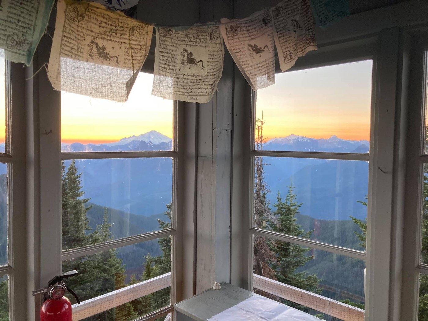
After unpacking a bit, we made tacos at the lookout. Another couple arrived a few hours later with their dog, so we all shared the lookout for an amazing sunset with spectacular views. Also saw a couple of pyro-cumulus clouds develop in the north & east from nearby fires. The moon-rise was fabulous as well.
There wasn't room for all six of us in the lookout (there are two platforms), but the couple with the dog found a level campsite (sparse at the summit due to the remaining snowfield) by retreating down the trail a bit. As I just mentioned, there was still a snowfield on the summit with a few deep melt puddles, which I used to filter water. It was ok. Boiling snow would have been an option too, but at the time I was concerned about our fuel supply, so I pumped. Bugs were a nuisance on the ground, but not up in the lookout.
Sunrise cooked us awake through the lookout windows the next morning & we were back on trail about 9:45 am after a leisurely breakfast, and bidding farewell to our lookout buddies. Retreating back to the junction was quick, but again, my GPS contradicted the map on the long side (both on the ascent & descent, my GPS showed 2.15 miles, whereas the map shows 1.9 miles on that section). We reached the junction & turned left up the hill to begin the most grueling section of the trail. The first mile past the junction briskly gains elevation. The tight switchbacks don't provide much relief from the steep trail. We encountered two major-ish blow-downs on this section. We went under the first one, then removed our packs & went over the second.
After about a mile and a quarter, the trail exits the forest. Here, we encountered a small snowfield. Its easy to navigate, but we had to be careful not to step through the snow getting on & off. Following the snowfield, the trail gains for another quarter mile. Lookout Mountain & Mt. Baker come back into view from behind, before cresting the hillside, at which point the lake comes into view ahead & the trail begins a half-mile descent into the basin, crossing one more snowfield. I had the trail to the lake at 2.5 miles (the map says 2.1)
We reached the lake shore & after a little scouting, decided to proceed around the west side of the lake, taking the trail just past the toilet on the left, and over a small rock outcropping, before dropping our gear & setting up in a large campsite with a mixture of sun & shade. The sites are well established sites with a level, gravel floor.
After setup, we headed back down to the lake shore for some fishing (I had made sure to purchase the required license at the Chevron in Marblemount), but had no luck. The water was crisp, but did make for a nice, albeit brief, swim. Another couple arrived after a couple of hours intent on scrambling up Little Devil Peak in the morning.
Sadly, I found a few pieces of broken glass near the lake shore. Packed out what I could find, but be careful if you elect to go barefoot here at all. Mosquitoes & flies were persistent, but tolerable, for most of the day, but around sunset, the gnats became particularly assertive & we needed to retreat to our site for dinner.
Slept a little later the next morning & had a leisurely, delicious breakfast before slowly packing up to head out. The hike out was beautiful & we were lucky enough to spot a large black bear traversing the cirque on our ascent back out of the basin. The bear was a considerable distance & across a talus field & we watched him through our binoculars for quite a while as he made his way back towards the lake, before we proceeded in the opposite direction of Yogi.
The blow-downs are easier to scoot under on the descent, and the nettles seem easier to spot & avoid moving down the brushy section below the junction.
When we arrived back at the car, we packed up & left, but upon arriving home, my buddy noticed he was missing his poles (REI Traverse) & had left them at the trailhead, so if anyone happened to grab them there, feel free to reply & let me know.
Otherwise, this is a great trip for a couple of nights. I think the trail is a bit longer than the map indicates (either 5.4 miles to the Lookout or 5.75 miles to the lake), but hey, that's just bonus hiking :). It was fun to finally stay in a lookout & Monogram is stunning. Would like to return some day for some additional scrambling up and around Little Devil Peak.
Cheers & happy trails!


Comments