

We were out on Ross Lake for 2 nights, camping at Lodgepole both nights and taking a day trip up 7300-foot Bear Skull Mountain (off the Devils Dome Loop Trail).
There was a trail crew working the East Bank Trail and the Devils Dome Loop Trail (up to the National Forest boundary). When we were there, they had just reached Devils Junction. So the entire East Bank Trail and lower part of the Devils Dome Loop Trail will probably be clear in the next week or so.
On Saturday, we arrived at the WIC in Marblemount at 6:30 am, took a ticket, and had our permit by 7:15 am (we were 5th in line). We parked at the Ross Dam Trailhead on SR 20 and portaged our canoes 400' down the 0.7-mile trail to the road then followed it 0.5 miles and 200' down to the lake. From there, it was a 10 mile canoe to Lodgepole. The portage took 1 hour, and the canoeing was another 6 (including breaks). After arriving at camp, I ran up the East Bank Trail above Lightning Creek. There were many blowdowns, some difficult to cross. The trail offers great views just 500 feet up.
On Sunday, we canoed 2 miles back down the lake to Devil's Junction to start our hike up Bear Skull Mountain along the Devils Dome Loop Trail. The trail became completely snow-covered as it rounded to an east aspect at 5750', and looked to be mostly snow-covered for the rest of the loop (it'd be best to wait at least a month before doing the full loop). There were several dozen blowdowns before this point, none too difficult to cross. We cleared half of them and made the rest more easily passable. The three seasonal creeks (at 4090', 4550', and 4750' according to my watch) were flowing well, with the first being the healthiest and maybe the only one which will last into fall. After Dry Creek Pass, the trail was too obscured by snow to follow, so we just took the ridge up. The steepness of the snow to the summit approaches 35 degrees, but it was the perfect density for kicking steps, so traction was unnecessary (we only had poles). It's a gorgeous non-technical summit with views of all of the North Cascades, including two volcanoes (you can only see Glacier Peak from the east end of the summit ridge). The glissading down the top 1000' was sublime. The upper half of the hike offers near-constant views of Jack Mountain. Stats for this hike: 13 miles, 5780' gain, 9.5 hours. Canoeing back to Lodgepole, we picked up a strange west wind radiating from Skymo Creek (perhaps a local circulation driven by the recently-sunny slopes east of the lake and shaded, snowy slopes above Skymo Creek).
On Monday, we canoed back to the Ross Dam boat launch and portaged the boats up to the highway. Taking a break at the road-trail junction and walking down to the dam was worthwhile. This portage was the least pleasant part of the trip, but at least it was immediately followed by dinner at Glacier Peak Eatery!
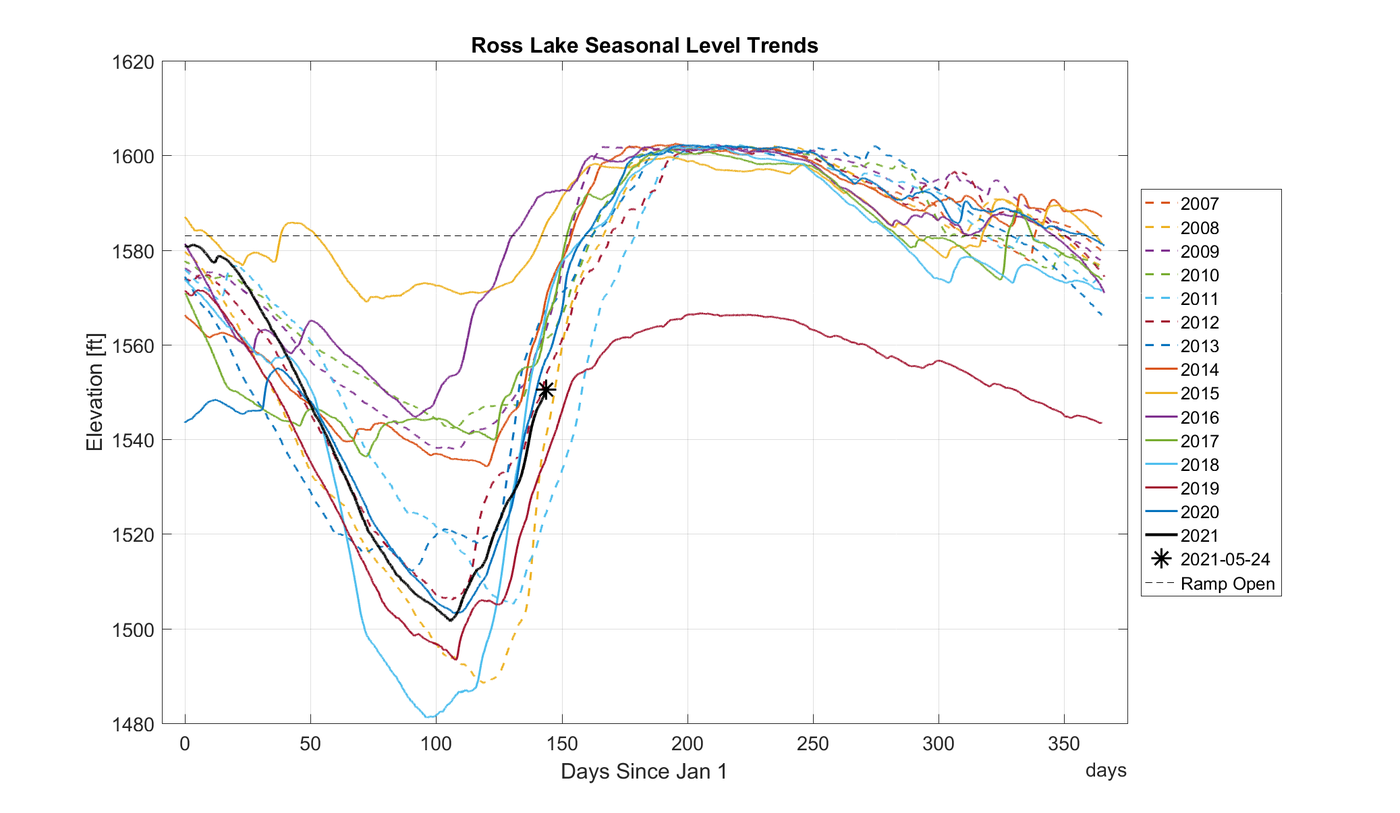
The lake was at 1558' when we started our trip and is rising at 1.5' per day. So it should be full pool (1600') by the end of June. Because the Ross Lake Resort isn't open yet and the lake is too low for the Hozomeen ramp (and the border is closed), the lake was very quiet. We saw one other canoe, two power boats, and a float plane. Lots of folks backpacking up the East Bank Trail though.
We ran into a Ross Lake Resort staffer, and he said they were considering starting their Diablo Lake to Ross Lake portage service as early as Memorial Day weekend next year. That would make the lake much more accessible in the Spring before the resort starts normal operations (when the lake is at full pool).
We were pleasantly surprised by the lack of mosquitoes given the warm weather, lack of wind, and proximity to the lake. I guess there isn't much mosquito breeding while the lake level is low (and the shore is entirely rocky).
Note that the Lodgepole campsite is actually located 1/4 mile south of where it is on Forest Service topo maps (and Open Street Map). It's well-signed from the trail and the water though, so you won't miss it. Lodgepole still uses a log as a dock, but the rest of the boat-in campsites have new aluminum docks. Every campsite seems to have received an upgraded outhouse in the past 2 years. Some had toilet paper, some didn't.
There are links below to: 1) a photo sphere from the summit of Bear Skull Mountain, and 2) a CalTopo map with our routes (among other routes).


Comments
Milarepa on East Bank Ross Lake, Devil's Dome Loop
Best post I've found on doing this hike from the lake. Thanks for the pictures and information. On the day of your hike, after reaching Devil's Junction, were you able to carry your canoe up to level ground, or did you just leave it a few feet above the shoreline? Terrain looks pretty steep there. The 35 degree ascent was up Bear Skull - how steep was the final slope to the summit of Devil's Dome? What was the daytime temperature up there? Did you see any spots to camp below the snow line? We are thinking of paddling kayaks up from Ross Dam in late May this year and hiking to Devil's Dome, but not sure about doing it in a day. You said 10 hours - do you consider yourself fast hikers? I'm in my sixties and have slowed down a bit, but did one 18 mile day last summer in the Olympics - mostly downhill.
Posted by:
Milarepa on Feb 12, 2022 11:19 AM
LostLemonhope on East Bank Ross Lake, Devil's Dome Loop
-At Devil's Junction, we just carried our canoes 5 feet up the rocky shore and tied them to a stump or a rock. There isn't much level ground to speak of, unless you bring your boats all the way to the campground (but there were folks camping there, and getting boats up the last little 2-foot step at the full-pool shoreline would be tricky). We did the same thing at Lodgepole: leave the boats on the shore a few feet above the current water line, and tie them off. If you're visiting the lake below full pool, I found a trick to see how steep the exposed lake bottom is. On CalTopo, the terrain data is taken from a LIDAR scan when the lake was ~50 feet below full pool (at 1552'), and you can query this data with the cursor or using the "slope angle shading" overlay. I used the overlay to determine accessibility of campsites below full pool (e.g. lodgepole is an ankle-twisting 30 degree slog, but Devil's Junction is a much more gentle 20 degrees). I'd add a picture to this report, but I'm at my limit! You can also find bathymetry data online.
-We didn't actually head up to Devil's Dome proper; we veered off to Bear Skull before getting that far. On the map, the maximum steepness to Devil's Dome looks a bit gentler than Bear Skull, maybe 30 degrees. It does require quite a bit of traversing.
-Temps on Bear Skull were quite pleasant compared to the heat down at the lake. I'd guess it was 50 degrees with a bit of a breeze.
-I don't recall any flat spots on the trail above about 3000'. You might consider camping on the snow at Dry Creek Pass (5900').
-I would consider us fast hikers, but not extraordinarily so. Maybe 75th percentile of the backpacking crowd in WA.
Good luck with your trip! Spring is a great time to be on the lake.
Posted by:
LostLemonhope on Feb 26, 2022 01:07 PM