
Hiked a fairly new trail system ~12 miles Round-Trip - 6 minutes drive west of Kettle Falls.
Directions to the TH - head west on Highway 20 from Kettle Falls, cross the bridge over the Columbia, then take the next left to stay on Highway 20. Head south a couple miles and the Sherman Creek WLA HQ Trailhead is on your left.
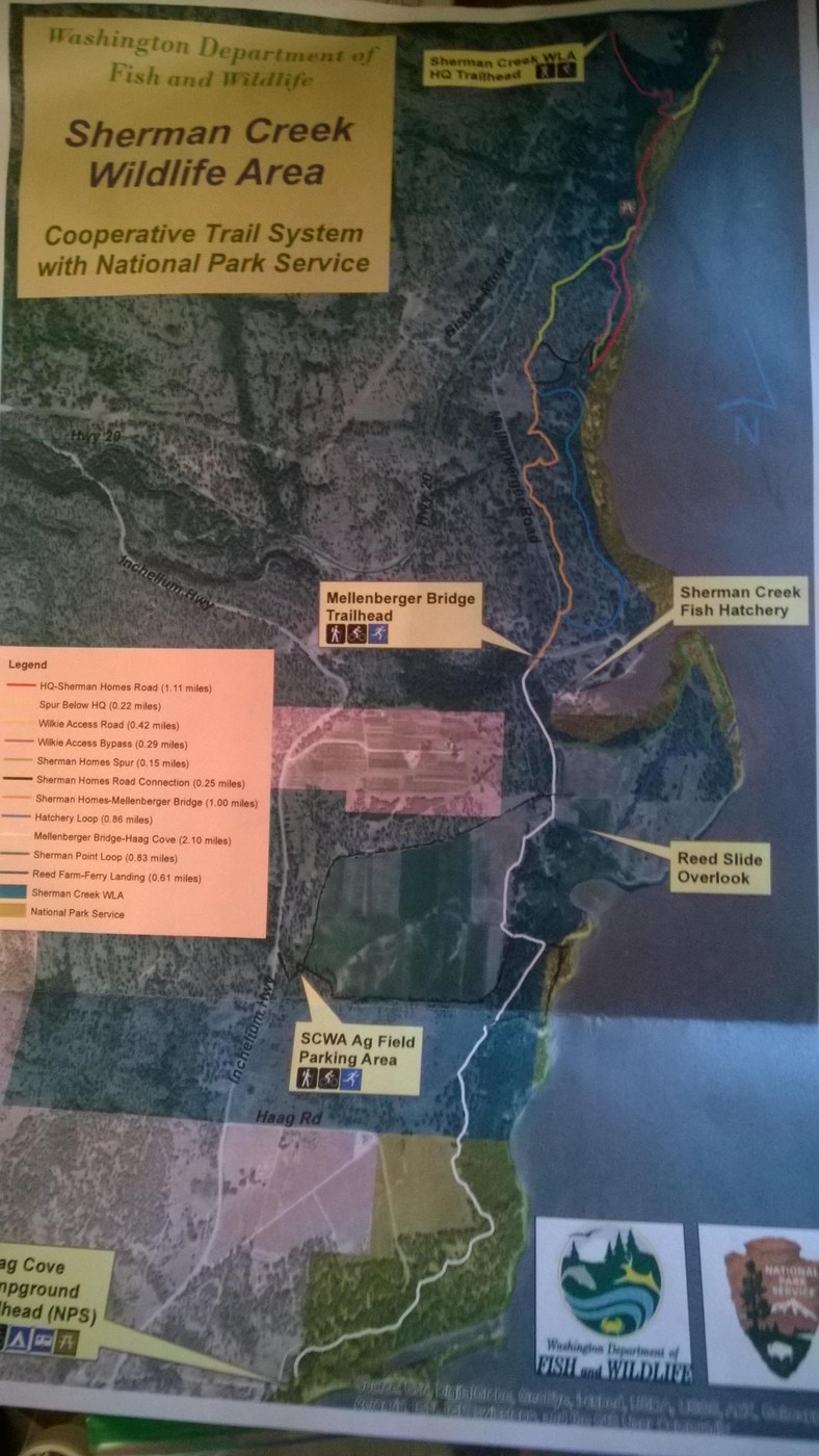
Note this TH does not currently specify needing a parking permit but other trailheads at Mellenberger Bridge and SCWA Ag Field both require a discover parking pass, as does the picnic area just south of Sherman Creek HQ Parking. The map shows Haag Cove Campground as a Trailhead but it isn't clear to me where you'd park that isn't a designated campsite.
This trail system as a whole is excellent, with commanding views of the Columbia and mountains around, plenty of loops, beach access, wildlife (Deer, Moose, Owls, etc), and even apples (!).
Much of the way is unsigned so I provide here a description of the trails as I have hiked them.
From Sherman Creek HQ TH, on the south side of the parking lot is a giant board describing the Sherman Creek Wildlife Area. The trail heads through a gap in the low wooden fence, off to the right towards the highway. Leaving the parking lot you enter a mature pine forest that was part of the Boyd fire (2018). The route winds around and loses elevation to go towards the Columbia. Pass a marshy low spot on the trail, there is a T intersection. If you head left it dead-ends out to a picnic table with a lovely riparian view of the lake. Heading right takes you through the forest to a bridge built in 2013 as an Eagle Scout project, just prior to a picnic table and wide, grassy clearing. You could drive to this place but the road is steep, narrow and muddy, and it is not listed on the map as parking, but is signed discover pass required up the road.
At this point you can choose to head east a dozen yards or so to the beach via boot path, or continue straight south on a grassy, muddy road.
100 feet or so along the clearing as it narrows to become a road and the trail stays straight while the road heads uphill to the right. Staying on the trail provides a nice walk through the forest with views of Lake Roosevelt. Your way continues south until the trail abruptly goes up to a wide county dirt road. Immediately before you ascend to the road, you can make a very sharp switchback to the right under a pine to keep the trail, which leaves the forest in favor of open brush. This will proceed, brushily at times, up to a grassy road (the same road that less pleasantly comes from the picnic site earlier).
Heading left on this road, you swiftly join the county road, where you can turn right and walk uphill along the shoulder for a few hundred yards. At this point there are two options to consider: Keep a keen eye for a low, less brushy spot on your south/left side where a faint trail heads uphill, OR continue until a faint road heads left. If you opt for the first way, you will ascend on the trail to the top of a small hill and bend to the right before descending to a road, and your way lies to the left, with the northern blue trail junction immediately thereafter. If you opt for the second way (orange on the map), head left on the faint road and follow it for 5 minutes or so south to the blue trail junction - the clear wide blue trail heads left down through otherwise brushy forest.
Following the blue trail down towards the Columbia, you will see the county road and a couple homes immediately and steeply downhill from the trail. The trail, however, stays above the road and swings to the right to continue its southward journey. Continue along this segment of the trail, cross a bridge, and continue south on trail again completed by the Boy Scouts, along the old railroad bed as you catch views of the Columbia through the lovely pine forest as you weave your way in and around the pines.
The trail eventually encounters a couple wide track leading steeply uphill north (the orange road) and then south to the right, and you can see pavement downhill to the left. Stay on the railroad grade and weave through the pines and lush bed of needles and cones and in 100-200 yards you will follow the single track trail as it heads uphill to the right to leave the railroad grade. This part of the trail is not on the map but is preferable to walking Mellenberger road, the route shown on the map. There are easy to miss large cement blocks here, but the trail gains ~30 feet and crests a small hill overlooking Mellenberger Bridge Trailhead with a large decommissioned bridge immediately yonder over a gorge, which the trail then descends directly to, fading into the landscape 10 yards from the actual parking lot. Turn around and remember how you came, for the path is not obvious from the parking lot.
You can cross the large bridge south on foot, taking a minute to appreciate the view of the gorge and water below, and catch a glimpse of the fish hatchery to your left with the Columbia as a backdrop. On the other side of the bridge, follow an old paved road that has since largely been covered with forest needles. Pass two picnic tables on the left side of the road, and look for a path to the left, green on the map.
Take a left on the green trail, and walk along the top of the bluff, with a field and good views of the Huckleberry subrange of the Selkirks to the east and south. At this point and south a lot of places have been badly eroded, so be careful not to get too close to the edge. Follow this wide path as it gradually loops left, keeping left to descend northeast to the end of the point where there is a breezy picnic table with excellent views.
After soaking in the views continue south (right) with good views of the Columbia for awhile before the path swings inland to a junction. Left takes you down to the water but the shore there is steep and rocky. Instead head right, which ascends through very open pine forest and fields as the views continue to improve with the ascent. Under 100 feet shy of a picnic table with 360 degree outstanding views but no shade, head right to head west, the trail now following the edge of a field (looks like wheat) on the right and cliffy drop on the left. In a block or so you will reach a large intersection, the road to the right (white on the map) goes back to Mellenberger Bridge TH the fast and less scenic way. Our path, however is to make the large turn left again through very open pine forest, to head southwest along the top edge of the plateau.
In no time, the trail will reach an active farm field and continues to the left right next to the field. There are one or two side trails that stick to the very edge of the bluff and return to the wide path alongside the field, but continue south until the wide path heads left into the forest. There is a game path along the bluff for this section but it is dangerous.
You will see a path headed straight off to the right. This is not marked on the official map but I penciled it in as it goes south then loops to the right along the edge of farm fields, and ultimately heads west 1/2 mile or more to the SCWA Ag Field Parking Area.
Rather than heading to the Ag Field Parking Area, if we stay straight on the wide path it descends to a picnic bench perched on the top of a cliff, with a once paved wider road headed to the right. The white path on the map follows this road, but if you look southeast towards the Columbia from the picnic table you can pick up a nice singletrack trail through the woods instead that offers a better hiking experience. Watch out for erosion and cliffy sections but the trail is mostly safe as it winds its way through lovely forest with mountain and water views. If you choose this option, eventually head left when the trail rejoins the road.
Either way you go, you will eventually find yourself passing through an opening in a fence then continuing south. At this point the path stays in forest as the path winds its way slowly south past a singularly short but troublesome thorny rose patch threatening your raingear, to ultimately reach, after 6 miles of excellent year round hiking and snowshoeing, Haag Cove Campground and beach access and restrooms!
Remember where you came out (back of site 17), because the trail is not obvious from the Campground.
Most years there would be snow this time of year; there was a little in a couple places but no more than a couple inches for a few hundred yards in this low snow year.

Comments