Trails for everyone, forever

Home Go Hiking Hiking Guide Yurt Snowshoe

Yurt Snowshoe

Mount Rainier Area > SW - Longmire/Paradise
46.7060, -121.9932 Map & Directions
Length
12.5 miles, roundtrip
Elevation Gain
1,740 feet
Highest Point
4,100 feet
Calculated Difficulty About Calculated Difficulty
Hard
The Yurt provides a cozy retreat in the wintertime. Photo by Mare. Full-size image
  • Dogs allowed on leash
  • Established campsites
  • Mountain views

Parking Pass/Entry Fee

Sno-Parks Permit
Saved to My Backpack

The Yurt is by far the most secluded of the four huts within the Mount Tahoma Trail System. A cozy studio in the wilderness surrounded by trees with easy access for a day hike to Griffin Mountain, you'll have to really hoof it through the snow to get there. Continue reading

Rating
5.00 out of 5

Hiking Yurt Snowshoe

The lower parking lot has a pit toilet facility for use before starting on your trek. From the lower parking lot, hike uphill for two miles, and arrive at a junction where the groomed road veers off to the right and a trail in the woods heads left. To the left is the Lower Yurt Trail. Take a left and head into the dense forest, across a footbridge and through the quiet forest.

After 1.64 miles on the Lower Yurt Trail, stay right and continue for another 1.51 miles. Here you will come to the junction that provides access back up the hill to Snow Bowl and High Hut. Stay to the left and continue on the forest road for 0.82 miles. Here you will come to the trail for Griffin Mountain.

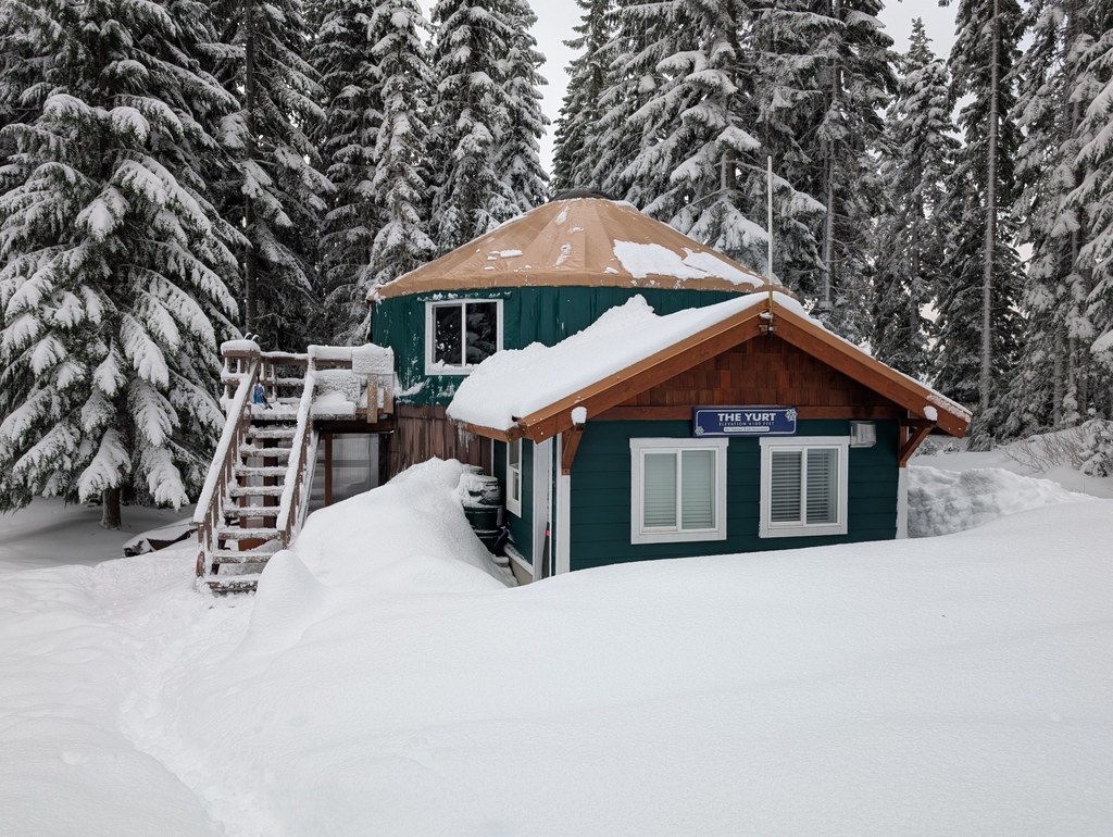
Take the road to the right for another 0.27 miles to the Yurt. Keep an eye out to the west, and you will see Snow Bowl Hut in the distance.

The Yurt can also be accessed by taking the forest roads up towards Snow Bowl. From the top saddle on the way to Snow Bowl, take the road to the left, and stay to the right for 2.42 miles to access the Yurt.

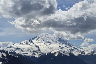
A day hike is possible from the Yurt to Griffin Mountain, which is 3.8 miles round trip from the Yurt and provides excellent views of Mount Rainier! All huts have a wood stove, oven, stovetop, bunk beds/mattresses, outdoor pit toilet and cooking utensils.

WTA Pro Tip: Navigating snow travel can be difficult and dangerous! Be prepared by looking at trip reports (below), reading about the hike on the Mount Tahoma Trails Association website and brushing up on our winter safety tips.

Reservations

Each of the huts are open and free to enter during the day, but from 7 p.m. to 7 a.m., guests must have advance online overnight reservations. Reservations for The Yurt can be made on the Mount Tahoma Trails Association website.

Hike Description Written by
Heath Jones, WTA Correspondent

Yurt Snowshoe

Map & Directions

Trailhead
Co-ordinates: 46.7060, -121.9932 Open in Google Maps

Before You Go

Reservations must be made to stay overnight in the The Yurt. See the hike description for more details.

See weather forecast

Parking Pass/Entry Fee

Sno-Parks Permit

WTA Pro Tip: Save a copy of our directions before you leave! App-based driving directions aren't always accurate and data connections may be unreliable as you drive to the trailhead.

Getting There

From Elbe, drive east on SR 706 to just a mile before Ashford (about 8 miles). Look for a Baptist Church on the right side of the road, and turn onto the road just before it. This is DNR Road 1.

Road 1 leads straight to the sno-parks for the south district of the Mount Tahoma Trails Association. Proceed 6 miles from 706 following the Sno-Park signs to the upper sno-park.

Note: Sno-park permits, not Discover Passes, are required between November and April. Discover Passes are required between May through October. 

More Hike Details

Trailhead

Mount Rainier Area > SW - Longmire/Paradise

Washington State Department of Natural Resources

Guidebooks & Maps

Mount Tahoma Trails Association Map (Available at Whittaker's Mountaineering in Ashford)

You can improve or add to this guidebook entry!

Yurt Snowshoe

33 Trip Reports

Hiked here recently?

Submit a trip report!
 
Loading trip reports...
Trip Reports