Trails for everyone, forever

Home Go Hiking Hiking Guide Columbia Plateau Trail - Washtucna Coulee

Alert: We are still in the midst of an active disaster. Learn more and how you can help.

Landslide risk, tree-fall in saturated soils and related hazards remain very high and have closed trails and roads, including major highways and forest roads. 

Respect closures, check forecasts, consider delaying your hiking or recreation plans, and stay safe out there.


Columbia Plateau Trail - Washtucna Coulee

Central Washington > Tri-Cities
46.6392, -118.5531 Map & Directions
Length
7.0 miles, roundtrip
Elevation Gain
140 feet
Highest Point
940 feet
Calculated Difficulty About Calculated Difficulty
Moderate
Washtucna Coulee reflects a history shaped by Ice Age floods and an old railroad. Photo by Mary J. Hartman. Full-size image
  • Dogs allowed on leash
  • Wildflowers/Meadows
  • Wildlife

Parking Pass/Entry Fee

None
Saved to My Backpack

A segment of the Columbia Plateau Trail passes through a former railroad tunnel and along an ice age coulee, past the dried basin of what was once Lake Kahlotus. Continue reading

Rating
3.40 out of 5

(5 votes) Log in to rate

Hiking Columbia Plateau Trail - Washtucna Coulee

Columbia Plateau Trail State Park is a 130-mile corridor on a former railroad grade from Cheney to Pasco in eastern Washington. Much of the trail is currently undeveloped, including this hike along a shallow coulee near the small town of Kahlotus.   

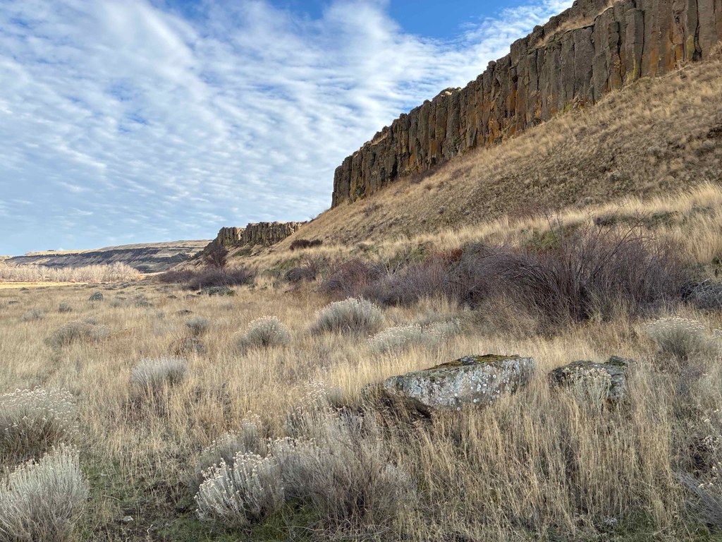
During the last great Ice Age, the Great Missoula Floods carved out channels with steep walls and flat valley floors known as coulees. Washtucna Coulee isn’t as deep as some of its cousins, but it offers dramatic views and wide open spaces.

From the pullout along the Pasco-Kahlotus Road, make your way down to the railroad grade. If you’d like to walk through a tunnel before you hike the coulee, turn right. The tunnel is longer than it appears from the entrance (0.4 mile), and it helps to have a flashlight. It emerges in narrow Devils Canyon.

To hike Washtucna Coulee, retrace your steps through the tunnel and head east. You’ll walk past steep basalt cliffs, sagebrush, and a small cottonwood grove. The trail runs along the south side of the coulee, past the topographic low that was Kahlotus Lake when the water table was higher; the lake is now dry. Along the way, spot some splendid plants and wildflowers, like sage violets, buttercups, desert parsley and more.

About 3 miles from the trailhead, you’ll reach a short railroad bridge. You can cross it by walking on the ties if you want to continue. Otherwise, turn around and return the way you came.

WTA Pro Tip: The trail surface consists of angular basalt gravel that can be tough on feet, so wear boots with rigid soles, and keep an eye on your dog's pads as well. You may want to walk alongside the railroad grade where conditions permit, taking care to stay within the park boundary.

Toilet Information

  • No toilet at trailhead

More information about toilets

Hike Description Written by
Mary Hartman, WTA Correspondent

Columbia Plateau Trail - Washtucna Coulee

Map & Directions

Trailhead
Co-ordinates: 46.6392, -118.5531 Open in Google Maps

Before You Go

See weather forecast

Parking Pass/Entry Fee

None

WTA Pro Tip: Save a copy of our directions before you leave! App-based driving directions aren't always accurate and data connections may be unreliable as you drive to the trailhead.

Getting There

From the Tri-Cities, drive north on the Pasco-Kahlotus Road. Drive 0.3 mile past the junction with WA-263. Just past the end of the guardrail, there’s a gravel pullout on the east side of the road with room for 2 or 3 cars and a short stub of a gravel road. Park in the pullout and walk to the end of the stub road, then bear left on a social trail that will take you down to the old railroad grade.

Alternatively, from WA-260, turn south on WA-263 to Kahlotus. Drive 0.4 mile to the pullout described above.

More Hike Details

Trailhead

Central Washington > Tri-Cities

Washington State Parks

Guidebooks & Maps

Best Desert Hikes: Washington (Bauer & Nelson - Mountaineers Books)

https://parks.wa.gov/find-parks/state-parks/columbia-plateau-state-park-trail

Washington State Department of Natural Resources (DNR) Connell

USGS Kahlotus

https://parks.wa.gov/sites/default/files/2023-04/Columbia%20Plateau%20State%20Park%20Trail%20Map%20-%20Lincoln%20to%20Franklin%20counties.pdf

You can improve or add to this guidebook entry!

Columbia Plateau Trail - Washtucna Coulee

8 Trip Reports

Hiked here recently?

Submit a trip report!
 
Loading trip reports...
Trip Reports