Trails for everyone, forever

Home Go Hiking Hiking Guide Reflection Ponds via Greider and Boulder Lakes Trail

Alert: On Oct. 1 the federal government began a partial shutdown that will impact National Parks, National Wildlife Refuges and U.S. Forest Service lands in Washington. Here's the latest information we have for hikers and campers


Reflection Ponds via Greider and Boulder Lakes Trail

Central Cascades > Stevens Pass - West
47.9737, -121.6135 Map & Directions
Length
4.82 miles, roundtrip
Elevation Gain
239 feet
Highest Point
1,558 feet
Calculated Difficulty About Calculated Difficulty
Easy/Moderate
View of Spada Lake from Bear Creek Viewpoint. Photo by seagully. Full-size image
  • Dogs allowed on leash
  • Lakes
  • Rivers
  • Waterfalls
  • Wildlife

Parking Pass/Entry Fee

Discover Pass
Saved to My Backpack

If hikers are interested in this relatively quiet portion of Snohomish County, but not up for the lengthy treks of Boulder or Grieder Lakes, then Reflection Ponds might be the right hike for you! The trail crosses multiple drainages, including Bear Creek, which offers striking views of Spada Lake. Ultimately, the trail highlights a serene loop between the two Reflection Ponds. Continue reading

Rating
0.00 out of 5

(0 votes) Log in to rate

Hiking Reflection Ponds via Greider and Boulder Lakes Trail

Reflection Ponds is a portion of the Boulder and Grieder Lakes trail system; the trail begins at the south shore of Spada Lake. The trail commences hikers on a short dirt path surrounded by forest. Quickly, hikers emerge into a wider and more open section, which is old Washington State Department of Natural Resources road.

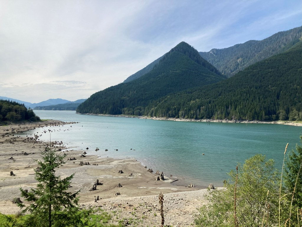
The hike continues, mostly flat, along two newly constructed bridges over McCarty Creek. The trail can be very brushy in the early summer, but hikers will be surrounded by salmonberries, blueberries and thimbleberries. After a mile along the river lined with birch trees, the trail will steadily ascend, and hikers have a lovely spot to break at Bear Creek Viewpoint. Here, hikers can enjoy the views of Spada Lake and the surrounding mountains. This site includes two port-a-potties, two picnic tables and one bench.

The trail continues a gradual gain from the viewpoint and over an old concrete road bridge atop Greider Creek. In the past, hikers were able to drive to the ponds and Grieder Lake trailhead, though the road has been decommissioned.

You know you’re at the ponds once there is a large clearing and trees dot the perimeter of the ponds. Some may not even realize a trail is there; it’s quite tucked away. There is an old wooden sign or two marking the entrance for the ponds. The trail takes you through a quarter-mile loop and over a footbridge between the two ponds. The loop offers serenity from the main trail and a chance to catch sight of local wildlife.

If you continue east on the main trail, it will take you to Boulder Lake, while hikers who venture beyond the ponds will approach the Grieder Lakes trail. A short yet pleasant hike, excellent for kids, families and new hikers!

Toilet Information

  • Toilet at trailhead
  • Accessible toilet

More information about toilets

Hike Description Written by
Maya Bingham, WTA Correspondent

Reflection Ponds via Greider and Boulder Lakes Trail

Map & Directions

Trailhead
Co-ordinates: 47.9737, -121.6135 Open in Google Maps

Before You Go

See weather forecast

Parking Pass/Entry Fee

Discover Pass

WTA Pro Tip: Save a copy of our directions before you leave! App-based driving directions aren't always accurate and data connections may be unreliable as you drive to the trailhead.

Getting There

Start on Highway 2, heading east towards Sultan. Turn left onto Sultan Basin Road and take a couple of left turns to continue on the road for 13.8 miles. Follow the road as it turns into gravel; the road was regraded in the spring of 2025. Although it is smoother, there are some steep, sharp turns on this road and AWD/4WD is recommended.

A self-issue permit station is just before the junction of NF-6120 or Olney Pass, not at the trailhead. Stop there before continuing.

Continue right at the fork. Then, stay right on NF-6129. NF-6129 turns left and becomes NF-6128; there will be a large parking area with vaulted toilets, port-a-potties and a boat launch at the trailhead. There is ample parking available.

More Hike Details

Trailhead

Central Cascades > Stevens Pass - West

Washington State Department of Natural Resources

Guidebooks & Maps

https://dnr.wa.gov/sites/default/files/2025-03/amp_greider_boulder.pdf

Buy the Green Trails Index No. 142 map

You can improve or add to this guidebook entry!

Reflection Ponds via Greider and Boulder Lakes Trail

1 Trip Report

Hiked here recently?

Submit a trip report!
 
Trip Reports