
There are two routes to Poe Mountain: this one via Irving Pass, and the steeper one up from the Little Wenatchee Campground. The ridge running trail from Irving Pass is more primitive with a couple of spots of scrambling. The Little Wenatchee Campground route is a south-facing trail with lots of switchbacks that climb an additional 1,200 feet due to starting on the valley floor. There are no water sources on either trail, so carry plenty of water for yourself and any four-legged hiking companions.
The Irving Pass route was significantly impacted when in August of 2022 lightning started a wildfire on both sides of Wenatchee Ridge, this fire was called the White River Fire and it burned 14,442 acres. The Little Wenatchee Campground route is reported to have not been impacted by the fire. On the Irving Pass route — notably the northern side of Wenatchee Ridge — did not burn. You are often hiking on the ridge top, amongst dead burnt trees; 25 feet to your right is a stand of completely untouched trees reaching all the way to the valley floor to the north. The fire did improve the views, which were good to start with, and are now really good. The summit area was not burned.
At this point, you are asking yourself: Given the fire is this worth it? Great views, a really good workout in a 6-mile roundtrip hike, 1,800+ feet of climbing, wildflowers and berries in season and likely very uncrowded. Fire is part of the ecology of the Central Cascades. This fire was pretty much a natural event; there was very little firefighting on the top of the ridge, no evidence of retardant drops. As of summer 2025, life is coming back in many sections. The fireweed bloom in July and August is spectacular. This trail was always rough, and there will be blowdowns to deal with for decades to come; it is just part of the renewal plan.
Although numerically easier (the Little Wenatchee Trail climbs 3,000 feet, to this trail's 1,800), you'll still get your workout hiking in via Irving Pass; this route hikes harder than it reads. However you reach it, the old lookout site on Poe provides excellent views in all directions.
There are no stream crossings, springs or reliable water on this trail, so make sure you are adequately supplied. There can be easily crossed snow drifts until midsummer on this trail, so be sure to check WTA's trip reports for current conditions.
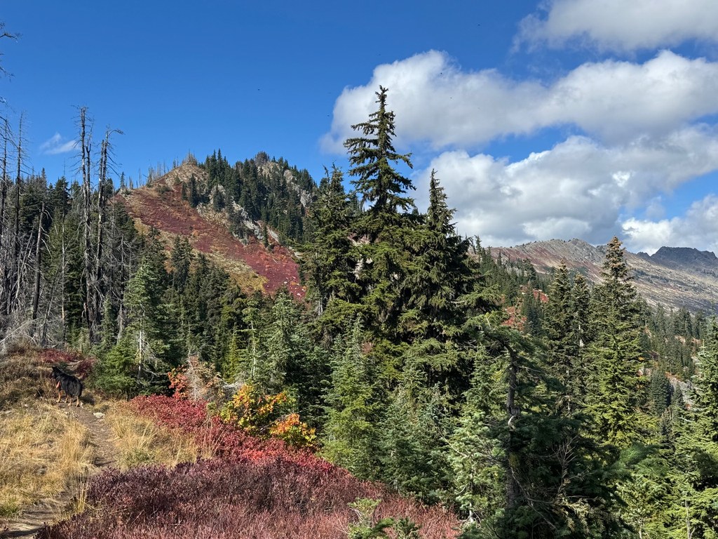
The Irving Pass route starts off from a parking area carved from an old logging road switchback. The trail makes a couple of easy switchbacks through an old clearcut before ascending steadily 600 feet in half a mile to Irving Pass. Ironically, this part of the trail used to be warm and sunny before crossing the wilderness boundary into the heavily forested ridge up to Irving Pass. Now the clearcut is shaded by 20+-foot saplings, and the fire damage starts right on the edge of the old clearcut. The climb to Irving Pass is switch-backed, and lots of fireweed has sprung up under the dead standing trees.
After a brief water and snack break, take the left onto Trail #1545. Nearby, there is an unmaintained trail used by high-country hunters that proceeds straight down into Cockeye Creek. It's not your route (and with a name like that, it's worth avoiding).
The trail will climb for a quarter mile through burnt trees, and then follow the knife edge ridge line for the remainder of the hike to the final approach to the summit. The ridge top is roughly 10 feet wide; the trail wanders among the few trees that managed to hang on top before they were burned. The views are great all the way along the ridge, alternating between looking southwest to Labyrinth Peak above Minotaur Lake and Rock Mountain, and to the south, Rainier can be seen on the horizon on clear days. Views to the northeast look up towards Mount David, Clark Mountain and Glacier Peak.
Roughly ¾ of a mile from the Irving Pass junction, the trail drops off to the northeast side of the ridge and a short scramble is required to regain the ridge. Early in the season this area can be snow-filled, and without safety equipment, it should be left for another day as the exposure is significant.
Once back on the ridge, the trail continues to climb steadily, either on the ridge top, or for short sections on either side. At a mile in a half from the Irving Pass junction, elevation 5,660 feet, a faint boot trail will Y off to the right. This rough track leads ¾ of a mile to a small tarn locally known as Cockeye Lake, the water source for the old lookout.
The trail will continue to climb through an open area with many huckleberry and mountain blueberry bushes, many of which survived the fire. The trail will crest a ridge and descend to a Y junction marked by a sign post, without a sign. A boot trail goes up to the right, this accessed what is known as “Faux-Poe”, aka False Poe. Continue down for ¼ mile through a draw, which can contain snow and melt ponds early in the season. You will encounter a faint junction at 2.5 miles, the trail clearly goes up to the right, an abandoned trail used to connect over to the trail coming up from Wenatchee Falls Campground, now accessible just below the summit.
This route to Poe Mountain provides lots of views, berries in season near the summit and a trail that has a few challenging sections. The conditions on the trail are going to be changing rapidly; part of the appeal of this trail is the opportunity to see the change in action.
Extend your hike
Adventurous cross-country hikers can continue along the ridge to Longfellow Mountain, Bryant Peak, Kodak Peak returning down the Meander Meadow trail to Little Wenatchee Campground. This is a big endeavor.
 Trailhead