
From the rather large (but nearly always crowded) Denny Creek trailhead, start out on a wide trail, practically a boulevard through the forest. After just a half mile of hiking, cross under the westbound lanes of I-90. Architects built the freeway here in the hopes of avoiding avalanches and rockslides. Now, if there are any rumblings from the peaks above, rocks or snow course beneath the interstate, rather than piling up on top of it.
Continue past I-90 and the traffic sounds fade away into forest noises and those of your fellow hikers. Just over one mile from the trailhead, arrive at the waterslide and look for strategically placed rocks for a dry crossing. In times of high water, Denny Creek can be dangerous, so if it’s running high, save this trip for later in the season.
Once past the waterslide, your hike changes character. What was an easy forest ramble becomes an uphill grind, as you switchback over exposed hillsides. Luckily, two waterfalls across the ravine offer photo (and rest) opportunities. The hike comes to a saddle. Contrasting with the hillside you just came up, this area is velvety green with underbrush and lush forest thanks to Denny Creek, which you now hike alongside.
After three-quarters of a mile of switchbacking, the green fades away, and you’re back on exposed trail. The granite rocks here hold heat well, so in the midday this can be quite hot. Start hiking early to avoid slogging through this area in the heat of the day. Begin to switchback up to a small saddle—Hemlock Pass.
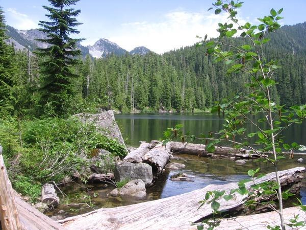
At 4700 feet, this is the highest point of the hike, but the views will come in a third of a mile and 200 feet lower, when you arrive at Melakwa Lake. This glittering jewel of a mountain lake is set in a granite basin, a diamond ringed by Bryant, Chair, and Kaleetan Peaks.
This makes a great first-night camp, though it is a popular destination. Again, an early start means you’re more likely to snag the spot you want at Melakwa. If you want a slightly different scene, look for a good spot at Upper Melakwa Lake.
On day two, head for Lower Tuscohatchie Lake. Return to the main trail, but instead of going back the way you came, take the trail heading downhill. It’s a 2.9 mile downhill hike to quiet Lower Tuscohatchie Lake through second-growth forests. This part of the trail is less-frequently visited, so you may have it to yourself. Lower Tuscohatchie doesn’t have many campsites; if you can’t find a free one, it’s only another half mile to Pratt Lake, which usually has more to pick from.
Either way, be sure to stop at Lower Tuscohatchie, and as you hike, take in the green hills of the Middle Fork valley rolling out to the north. This is a view that few hikers see, since most day hikers don’t pass Melakwa or Pratt Lake.
From Pratt Lake, traverse the east side of the lake, moving from underbrush to a talus slope. If Melakwa’s shimmering evoked diamonds, then Pratt's evokes a large sapphire. Its deep blue waters contrast well with the gleaming granite surrounding it—be sure and snap a photo or two. Leaving the talus, begin switchbacking up through forest and 1.4 miles from the campground at Pratt Lake arrive at a trail junction. Turn left. You’re on your last leg of the trip, 4.3 miles from the Pratt Lake trailhead. The trail traverses through open forest with one particularly notable viewpoint of Mount Rainier and Ollalie Lake, before gradually descending to the Pratt Lake Trailhead.
WTA Pro Tip: If you want another day or two in the backcountry, try taking the side trip to Kaleetan Lake, nestled at the base of Kaleetan Peak. 4.9 miles from Lower Tuscohatchie Lake, this trail is infrequently visited and you may be lucky enough to have a campsite all to yourself.
Melakwa - Pratt Lake Traverse

-
 Length
- 11.7 miles, roundtrip
-
 Elevation Gain
- 2,300 feet
-
 Highest Point
- 4,700 feet
Take a thru-hike among some of the I-90 corridor's most iconic lakes. Make it a day hike, an overnight, or take as much time as you like and really explore the area.
Continue reading
Hiking Melakwa - Pratt Lake Traverse
Map & Directions
 Trailhead
Before You Go
Parking Pass/Entry Fee
Northwest Forest Pass, Sno-Parks PermitWTA Pro Tip: Save a copy of our directions before you leave! App-based driving directions aren't always accurate and data connections may be unreliable as you drive to the trailhead.
Getting There
To start from the Melakwa Lake Trailhead (also known as the Denny Creek trailhead), take Exit 47 from I-90. At the top of the exit ramp, turn left and cross over the freeway. Go 0.2 miles and turn right at the stop sign onto Forest Road 58. The road crosses under the freeway, after driving 0.2 miles, turn left.
Continue straight on for 2.9 miles and about a half mile past the Denny Creek Campground there are three large parking lots on the right that can accommodate about 170 cars.
There is an electronic payment station at the first parking lot for those who do not have a valid pass. Road side parking is not permitted in this area so make sure you have a backup plan if the parking areas are full.
Various connector trails lead from the parking lots to the Denny Creek and Franklin Falls trails. There is ADA parking available nearer the Franklin Falls trailhead. Be sure to have a placard; parking patrols are on and will ticket violaters.
Note that this is a horseshoe hike, not a loop, so you will need to arrange either a key swap or a pickup from the trailhead you end at. If you opt for a pickup, consider enlisting friends who may already be bound for trails in the area, in order to save an extra trip.


