Trails for everyone, forever

Home Go Hiking Hiking Guide Marine View Park

Marine View Park

Puget Sound and Islands > Seattle-Tacoma Area
47.4145, -122.3397 Map & Directions
Length
1.5 miles, roundtrip
Elevation Gain
275 feet
Highest Point
275 feet
Calculated Difficulty About Calculated Difficulty
Easy
The shore of Marine View Park. Photo by Ken Giesbers. Full-size image
  • Coast
  • Dogs allowed on leash
  • Good for kids
  • Mountain views

Parking Pass/Entry Fee

None
Saved to My Backpack

This hidden gem offers picnic tables and benches with views over Puget Sound, and access to a section of public beach. The trail network can be confusing. Familiarize yourself with the map ahead of time. Continue reading

Rating
4.00 out of 5

Hiking Marine View Park

A short distance from the trailhead, you have options. To the left is the fast way down to the beach, on hard-packed dirt then asphalt (a maintenance access road). Beside the road are alder, cottonwood, maple, madrona, blackberries, some ferns and salal, and a LOT of invasive ivy. Even though it is paved, the path is too steep to be considered wheelchair-friendly.

Avoid the paved section in icy conditions. The alternative is to head right from the parking lot toward a plateau with a bench, picnic table, and view overlooking Puget Sound. Off to the right of that is a trail. Follow signs on the trail network "To Beach." 

The paved section and the “primitive trail” network meet near the top of a wooden staircase, where garbage and recycle bins have been thoughtfully provided. The continuation of the hike is down a short wooden staircase, then along a wooden walkway that connects to an impressive three-story folded staircase structure. Read the interpretive signage, then drop down the flights of stairs to the beach.

Beach walking is usually on cobbles. Watch your step. At lower tides, you can walk below the cobbles on coarse sand and seaweed, but take care not to disturb clam beds. The strip of public beach is 0.2 mile long. Boundaries are clearly marked by signed posts. There are plenty of beached logs to sit on. Did you bring a book to read? If not, just enjoy the ambiance. On a clear day, Mount Rainier dominates the southern horizon, and the majestic Olympic Mountains fan out above Vashon Island to the northwest.

WTA Pro Tip: There is no water on this hike, so be sure to bring enough water with you. In good weather, a popular plan is to take the pavement on the way down (0.4 mile), and the trail system on the way up (0.5 mile or more; explore the different view overlooks!). Both have benches, but the primitive trails offer shade and better views.
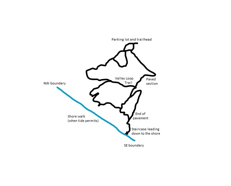
Hand-drawn map of Marine View Park by Ken Giesbers.

Toilet Information

  • Toilet at trailhead

More information about toilets

Hike Description Written by
Ken Giesbers, WTA Correspondent

Marine View Park

Map & Directions

Trailhead
Co-ordinates: 47.4145, -122.3397 Open in Google Maps

Before You Go

See weather forecast

Parking Pass/Entry Fee

None

WTA Pro Tip: Save a copy of our directions before you leave! App-based driving directions aren't always accurate and data connections may be unreliable as you drive to the trailhead.

Getting There

From 1st Avenue South in Normandy Park, travel north or south toward S 208th Street. Turn west on 208th and drive 0.2 mile to a "T." Turn left, then just 400 feet later, turn right into the parking lot. There is parking for about 20 vehicles. (If you rely on a navigation system, you could try this fictitious address: 20853 Marine View Drive SW.)

The park is open 7:00 a.m. to dusk. At the trailhead are portable toilets, garbage and recycle bins, and dog waste bags.

More Hike Details

Trailhead

Puget Sound and Islands > Seattle-Tacoma Area

City of Normandy Park

You can improve or add to this guidebook entry!

Marine View Park

3 Trip Reports

Hiked here recently?

Submit a trip report!
 
Trip Reports