
Take an amble through moss-laden forest and along churning waters in colors only the glacier-fed waters of the Olympic Peninsula can provide. For the most part, it’s ramble with moderate grade, but in the last two and a half miles, the trail changes character dramatically—putting you through a steep, thigh-burning workout before rewarding you with views of Mount Mystery and Little Mystery just inside the National Park boundary.
From the parking lot, walk back across the bridge over the Dungeness River and step immediately onto the Dungeness Trail. After an initial climb away from the road, the trail flattens out, and rolls along for a mile to a junction. The right-hand trail leads away to Royal Basin and Royal Lake, seven miles away, a great hike, but one for another day. Your trail is across the footlog over Royal Creek and into the Buckhorn Wilderness.
Follow the Dungeness River, and note the icy blue-green waters. This remarkable color is due to glacial silt that filters down from the high country sources of the Upper Dungeness River. It contrasts gorgeously with the fluffy mosses here in every shade of green, from lime to emerald. Be sure and get some photos.
After 3.2 miles of hiking, there is a fork in the trail. To press on, stay left, but if you need a rest, head right and downhill to Camp Handy. This is a nice camping area, with a three-walled shelter at the east side of a large meadow. Once you’re rested, rejoin the main trail and continue hiking another 0.3 miles to another trail junction.
The left-hand trail, signed for Marmot Pass, leads to Boulder Camp and eventually the pass. For a description of that hike, see our writeup for the Upper Dungeness River. For this hike, you’ll take the right-hand trail, which continues at a gentler grade for another three-quarters of a mile before breaking out into another open meadow, where the trail skirts the forest on the left side of the meadow. This meadow is about 4.5 miles from the trailhead.
In 2015, WTA volunteers worked on a large drainage project here. A seasonal creek blew out the trail, and a crew of eight volunteers spent part of a BCRT creating a diversion dam and refilling a section of the tread, which was more than two feet below ground level in places. Check out their handiwork as you press on.
The trail now becomes more rugged. It can be difficult to see as you pass through two more meadow areas, but as you head deeper into the forest, it’s clearly delineated, if a bit rooty. The forest floor along the trail becomes cushioned with a variety of mosses. Look for feather moss, oxalis, and many, many other types of lichens and moss.
About a mile from the site of the WTA project (and over one short but steep ridge climb) is your final log bridge to cross. This is also where the trail changes character, beginning an incline that becomes ever steeper as you near the end of the trail. Switchbacks are nowhere in sight, and opportunities for water become scarce as you near the boundary, so be sure and fill up where you can safely reach water.
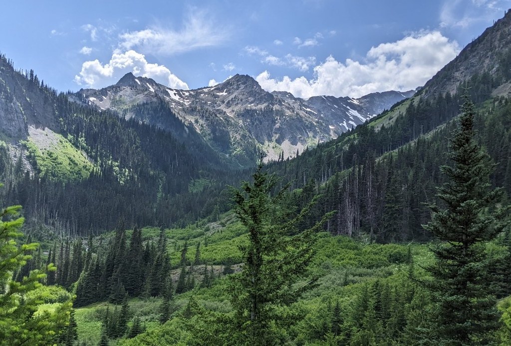
The last mile is the steepest and most exposed, but also offers views of Marmot Pass and Buckhorn Mountain, as well as glimpses of Heather Creek far below you in the valley.
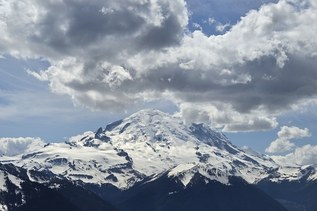
Then suddenly, you’re at the park boundary. The trail ends here, though there is one more camp just inside the park—downhill and to your left from the boundary sign. To your right is a short bootpath to a nice overlook of Mount Mystery to your right and Little Mystery straight ahead.
WTA Pro Tip: While they may seem superfluous for the first part of the hike, bring trekking poles with you! Your knees will thank you when you’re doing that last steep section.
Heather Creek Trail via Upper Dungeness River

-
 Length
- 15.8 miles, roundtrip
-
 Elevation Gain
- 1,800 feet
-
 Highest Point
- 4,200 feet
Take an amble through moss-laden forest and along churning waters in colors only the Olympic Peninsula can provide. For the most part, it’s ramble with moderate grade, but the last two and a half miles change character dramatically—giving you a steep, thigh-burning workout before rewarding you with views of Mount Mystery and Little Mystery just inside the park boundary.
Continue reading
Hiking Heather Creek Trail via Upper Dungeness River

WTA worked here in 2023, 2022, 2021, 2019 and 2018!
Map & Directions
 Trailhead
Before You Go
Parking Pass/Entry Fee
Northwest Forest PassWTA Pro Tip: Save a copy of our directions before you leave! App-based driving directions aren't always accurate and data connections may be unreliable as you drive to the trailhead.
Getting There
From beautiful Blyn on US 101, check your odometer at the intersection of 101 and Sophus Road on the west side of the Longhouse Deli and gas station. Head towards Sequim on 101. In 1.7 miles take a left onto Louella Road. Take Louella 0.9 miles to its end at the intersection with Palo Alto Road. Turn left on Palo Alto. Follow Palo Alto for 5.8 miles and turn right onto Forest Road 2880. This gravel road winds steeply down for 0.9 miles until you cross the bridge over the Dungeness River and drive past the Dungeness Forks Campground. In another 0.9 miles, you arrive at an intersection. Go straight (not right) on what is now Forest Road 2870. In another 2.5 miles bear right at an intersection to stay on 2870. In another 4.9 miles, take the left fork to stay on 2870. In 1.6 miles, you will again cross the Dungeness River and be at the sizable trailhead parking lot. Trailhead amenities include picnic table and vault toilet.