Gunn Peak, Wing Peak, Tailgunner — Nov. 9, 2025

![]() 9 people found this report helpful
9 people found this report helpful
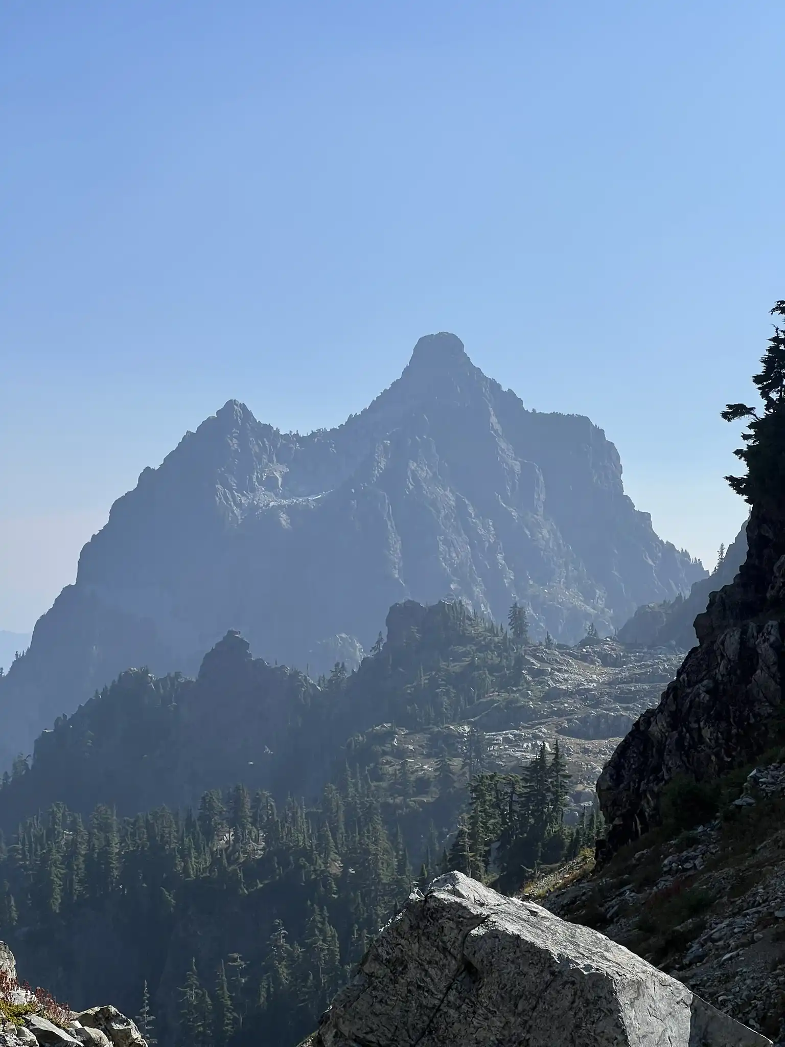
This is a report for ascent of Tailgunner and Wing Peak from the Barclay Lake trailhead - added it under Gunn Peak as these two ascents don't have entries on WTA. The path from Barclay Lake TH to the saddle is the same as to Gunn.
The path to the saddle between Tailgunner and Wing is overgrown and rough as previously mentioned, but nothing too intimidating, just slow with a bit of routefinding. Expect Class 2 scrambling and intermittent bushwhacking. It is steep, however, ascending ~3000ft in less than 2 miles. The waterfall gully crossing at ~4000ft is interesting - two of our party took the higher path against the rock face, which requires some veggie belaying, and our third party member found a lower route to climber's left that was a bit less spicy. Maybe a class 3 move or two if you take the higher route. No major snow patches below the saddle as of yet, as it's on a South-facing slope.
Tailgunner ascent itself is pretty chill, some class 2 moves with firm snow along the way no deeper than 6-10 inches near the summit. On the way down from the peak we took a small snow couloir route on the North face of the summit - probably wouldn't repeat that in the future as the runout is a bit cliffy without much space to arrest - we briefly pulled out our ice axes for that section.
The ascent was relatively straightforward to Wing Peak from the saddle with Tailgunner with snow cover around 6-12" depth. The final section at the summit block involved skirting around or traversing a small arete which was complicated by snow patches and slippery footing on low class 4 terrain. We decided to save it for another (drier) day. If you're looking to summit Wing, I say wait until next year if you're not comfortable with a slightly sketchy/icy scramble.
Our route is available on Peakbagger at the link below.
Gunn Peak — Sep. 20, 2025

![]() 17 people found this report helpful
17 people found this report helpful
This hike is extremely steep and fairly technical. Most of the other hikers I encountered had turned around at the rock scramble section below the famous Infinity Tarn.
I did a late-in-the-day dayhike up to the Infinity Tarn. Mindful of several trail reports about car break ins at the trailhead, I deliberately did this trail on a Saturday so there would be more people around. Folks were parked from the Barclay Lake lot all the way down to the start of the Gunn trail, so I just parked at Gunn.
This hike has clearly become popular. I shared the trail with around 20 other people total, and it's been hiked enough that the path is very clear with little route finding. That said, it would be wise to have GPS or a downloaded trail map. I used this for the creek crossing and one part of the upper rock scramble.
I've trained all summer on steep hikes and scrambles, but I feel like this was steeper than all of them: steeper than Putrid Pete's Peak, Snoqualmie Mountain, Kaleetan - and quite a bit steeper than Mailbox. The steepest part is the initial forest scramble for the first mile, most of which is loose dirt.
Despite reading all the reports, both here and on other sites, I screwed up the entry to the waterfall gully. Most of the photos online show it from the other side. Coming up to it in real life, the high route, the most difficult, looks like the main trail. The lower route is hidden behind a boulder. My 4th pic here is that split, note the brown boulder on the right with a cairn on top (the cairn had been tipped over which is why I didn't see it. Another hiker rebuilt it on our way back down). Upper route is a class 3 scramble, lower is class 2 and probably the better route.
I found the part after the forest scramble and waterfall crossing to be relatively straightforward, but there are several places with rock scrambles. I didn't feel like any of it was above a class 2, but I kept running into folks who'd turned around there.
I had originally planned on hiking just to Tailgunner given my late start, but once I was sitting at the Infinity Tarn I was so content with where I was that I didn't bother doing anything else. There are definitely a lot of fun places to explore here though.
Sadly, I could also see the clouds of smoke from the Labor Mountain Fire. The view was a bit hazy.
Coming down poles were critical. Going back through the waterfall gully I was fortunate to follow someone who had a better grasp of the route.
The hike to the tarn came in at 5 miles roundtrip, about 3200' of elevation.
Gunn Peak — Sep. 20, 2025

![]() 11 people found this report helpful
11 people found this report helpful
See more photo here
Chutang and I started around 7 am on Saturday near the Barclay Creek Trailhead. The lot was small and already full, so we parked by the spur road with several other cars. To our surprise, there were about 15 parties on the mountain. The guidebook’s claim that you will have the mountain to yourself no longer seems to be true.
We expected a clean creek crossing but never found one. Luckily, there are many workable options, and crossing was not a big deal. Once across, the boot path was easy to follow almost the whole way to the summit, with just a few class 2 and 3 steps. At the 4000 foot gully, prior beta paid off. We went back and looked right for a crossing instead of committing to the loose left side.
The steep trail soon led us to the boulder field and traverse. With GPS, the hidden ramp was easy to spot about halfway up. The boulder field itself was fine with solid rock, but the ramp had loose sections, so we took care not to knock anything down. The holds were not great, but they were manageable.
Above the ramp, the trail reappeared through trees. We then traversed right and aimed for the V notch. On the north side, we used trees to grip and the rock wall along a narrow ledge. It looks intimidating in photos but felt fine in person. A short scramble later, we stood on the summit of Gunn Peak. The views were fantastic despite the haze. On the way back, we stopped by Infinity Tarn, a quiet little spot and a nice bonus.
Gunn Peak — Aug. 22, 2025

![]() 13 people found this report helpful
13 people found this report helpful
An amazing night of solitude out at Gunn Peak! I had somewhat ambitiously hoped to hit Gunshy, Gunn, Tailgunner, and Wing - but after setting up camp and getting up Gunn and Tailgunner I decided a chill evening poking around with my camera sounded more fun. 😅
While the photos are beautiful and I know this place is becoming more popular, let me be very straightforward: THIS IS NOT JUST A HIKE. DO NOT UNDERESTIMATE THIS TRAIL just because you can find the track on AllTrails and it is lower mileage. On my way out on Saturday, I passed a few people trying to go up who were not prepared for the physicality and more technical nature of the trail (and I’m only talking the first 1.5 miles, not climbing Gunn itself).
The approach trail involves 3000’ of gain in a mile and change, some routefinding, and a number of areas that require the use of hands and feet to go up or down. I included a photo of one such vertical stretch. The trickiest in my opinion comes at around 4000’ when you reach the area of the dried waterfall basin. Here you have to drop STEEPLY on questionable footing and a very very narrow pathway and a fall would smash you up pretty good.
And, of course, if you get up you still have to get back down, which can be the scarier and more difficult part for those who aren’t familiar with that sort of terrain.
So, not to be a party pooper, but I think it’s important to be real about conditions. This one probably sounds pretty doable on paper to inexperienced folks - especially if they can’t really conceptualize what 3000’ gain is like - but is a challenging burner of a trail, even for people with plenty of skill. Don’t take it lightly, as it does involve comfort with difficult terrain and exposure even just to get to the famous tarn.
With all that said, I had a great trip! It took me about three hours to get up to the tarn area; I wasn’t originally planning on camping there, but given that there is no running water currently, I decided camping near a water source was the best bet.
There are plenty of sites to be had all around the general area, but please be gentle and remember to only camp on established sites or rock. There’s a lot of fragile, beautiful alpine goodness up there and it needs to be respected!
Besides the famous infinity tarn, there are two other tarns sort of above it to the right. Then there are some in the small canyon you cross to head toward Gunn. There is also a beautiful meadowy area below the Gunn trail that had several other tarns, though I only saw it from above.
Blueberries are insaaaaane right now. A great way to keep morale up as you slog.
I ran into two guys day climbing Gunn and we ended up climbing together. All the reports and beta you may have read are accurate. As you enter the boulder field directly below Gunn, curve right up the gully, aiming for the highest copse of trees on the side of Gunn. There is then an obvious sort of angle in the rock to scramble up. There is some dripping water here so be careful with your feet and hands where it’s wet.
From there, you wind through the trees out onto a scree field. There’s a bit of a trail but you eventually hang a left and head up an obvious gully that leads o a little notch. (Fun note: Baker is perfectly framed when you peek through the notch!).
Pop through the notch and work left along the narrow ledge. I didn’t find this ledge as narrow or worrisome as some reports described, but I’m also generally comfortable with exposure and heights.
A short rock scramble gets you to the summit!
We found the “register” - an old Nalgene bottle - but it’s just a collection of torn, loose pages and there’s no pen. If someone wanted to resupply sometime, that’d be great!
Flying ants were the summit kings, but weren’t insanely annoying.
On the way back, my new climbing buddies (shoutout Dane and Josh!) and I split at the Tailgunner turnoff; they were heading back to the cars and I wanted to get up Tailgunner before the day caught up with me.
Tailgunner is straightforward and fun. A nice large summit! Someone had left a little hot wheels car posed on a rock at the summit… in the spirit of leave no trace, I took it with me (but don’t worry, it will have a nice home with my nephew).
I probably would have had time to get up Wing but once down from Tailgunner and at camp I decided I was happy with my day as it was.
I had the entire expanse to myself until 6 PM or so when a lone overnighter arrived. He was planning an early summit the next morning and camped out of sight from me, so I still felt wonderfully secluded.
Woke up for sunrise, then packed everything up and made the slog back down. I had a couple tough moments downclimbing on the way out with my shorter legs, but I’m used to that!
Took a little over two hours to get back to my car. I knew there had been a series of recent break-ins at the Barclay Lake TH so I was holding my breath a bit, but all was well. Phew!
This was a great one and I’ll definitely be back. But it makes you earn it!
Gunn Peak — Aug. 11, 2025

![]() 22 people found this report helpful
22 people found this report helpful
Wow. This hike is no joke. You start by hiking about 1/3 mile on a hard to find at first flat trail. Then the trail kicks in and you are hiking straight up for about 1.5 miles. I put my poles away quickly as you need your hands to grab veggie belays and rocks and roots. Route finding can be quite challenging. I had both a gaia and AllTrails map downloaded and relied on them heavily. With the help of downloaded maps I made it to the summit. There were hords of flying ants. But I moved away from their central location so they didn’t bother me too much during my lunch break. You can see the Tarn from the summit which is pretty cool. Definitely made my way down faster that going up. I made the detour to the tarn and it was worth it. It’s quite beautiful. C2C in 8 hours, with a half hour lunch break and a side trip to the tarn. Only saw one other couple on the trail on a Monday. It was quite hot though. You’re out in the sun for about 70% of this hike.