
Enjoy breathtaking views of the Olympics from a secluded cove with many different types of seabirds and wildlife. Try to keep your feet dry while exploring a series of trails amid the historic 184-acre Guillemot Cove Nature Reserve.
There are a variety of ways to explore Guillemot Cove. This route offers a lot to see in just a couple miles.
Begin by hiking downhill on the Main Access Trail, located opposite of the parking lot. Ignore trails branching left and meet up with the Sawmill Trail. Continue right as the trail descends through a canopy of cedar, hemlock and fir, eventually becoming the Margaret Trail. Round a switchback and arrive at the bottom of the hill. Turn left, passing the rundown Nest House and emerge at a kiosk.
After periods of heavy rain, the meadow across from the kiosk can flood, making access to the beach difficult. If conditions (or waterproof boots) allow, cross the bridge over Boyce Creek and follow the rerouted Beach House Trail past the old house to the saltwater cove. Watch for seabirds, including the black and white pigeon guillemot for which the cove was named.
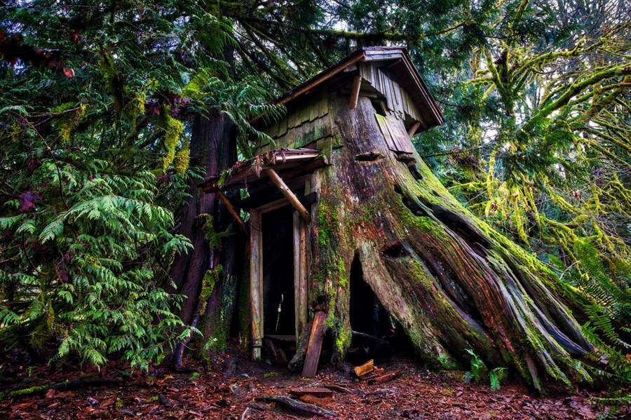
If a soggy meadow stops progress towards the beach, try hiking upstream along the creek on the Stump House Trail to its namesake: a large hollowed out cedar stump house with roof. The Stump House Trail isn’t obstacle-free; ensure careful footing on the slanted boardwalk that spans the creek as well as on slippery mud throughout the meadow.
For a possibly drier alternative, the Maple Tree Trail begins just past the fallen-down remains of an old barn a short distance from the kiosk. This level trail connects with the River Trail Loop and meanders beneath giant, moss-covered big leaf maples, some of which are more than 200 years old!
On the hike back to the parking lot, consider following the access road. The first obvious trail leading left reconnects with the Sawmill and Main Access Trail junction.
Note on the History of the Area
Originally home territory to the Twana people, Guillemot Cove was logged for cedar in the late 1800s. Springboard cuts are still visible in the large stumps near Boyce Creek and the Plateau. It wasn't until 1939 that Guillemot Cove began being preserved. A doctor from Berkeley, Eric Reynolds bought up the properties along Boyce Creek and created a summer retreat here. They renamed the area Guillemot Cove (it had been Frenchman's cove before, after Henri Querrette who owned a cabin on the North shore).
Kitsap County purchased the property from the Reynolds in 1993. The family sold the land at a reduced price with the stipulation it remain a nature reserve.

 Trailhead