
Gothic Basin will thrill and enthrall those who pay the admission. Day hikers will wish they’d brought their tents and bags and the backpackers will ache from shouldering the load. But neither will be disappointed. Be wary of this trail's apparently low elevation gain and mileage. It's quite steep, and most of the elevation gain happens in just two miles (making nearly 1000 feet per mile).
Steep sections of the trail remain snow-covered late into the season, and once it begins to melt out, snow bridges appear. Note also that depending on how far you wander once you arrive in the basin, your total mileage may vary from what is posted here. The data included here is for hikers heading to the popular Foggy Lake, about 0.3 miles from the saddle into Gothic Basin.
Your hike begins at the parking area in Barlow Pass with a one-mile road walk down a closed road that parallels the Sauk River. From the large parking lot, walk east along the highway for about 200 feet to a large gate with two signs requesting you to keep the area clear. Pass the sign and hike the closed road for 0.72 miles, looking for a trail heading off to the right.
After turning off the road, it's an easy 1.08 mile of forest rambling before Weeden Creek must be crossed. Take a moment to appreciate the creek — the trail begins climbing steadily as soon as you make the crossing. You'll continue through a very steep set of switchbacks, eventually popping out onto a slightly flatter section with nice views across the valley after another mile, almost exactly at the border between USFS and DNR land. You're leaving the Mt. Baker-Snoqualmie National Forest and entering the Morning Star Natural Resources Conservation Area. It's 1.41 miles from here to the Gothic Basin saddle, but you'll work for it.
The open area includes 3 creek crossings before the trail dives back into forest and continues climbing. You'll cross several more creeks, and take on some rock scrambling through here as well, though efforts from various trail crews (including WTA) have improved the route over the years. It's 1.45 miles of steep, exposed trail to the Gothic Basin saddle. Take it slow.
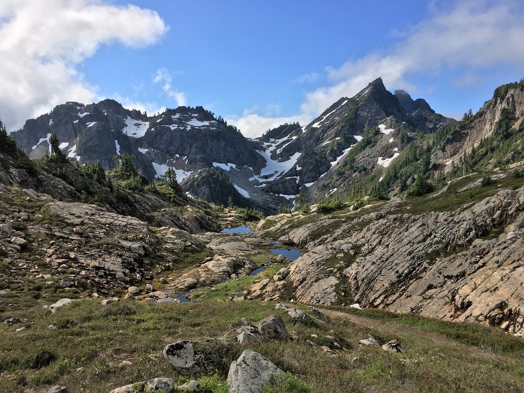
Along the way, enjoy the views, both micro and macro. The peaks of the Monte Cristo area loom off to your left. Some mining remnants remain, and abundances of wildflowers choke the trail well into the end of July. Snow crossings also last until late in the season. As always, caution should be exercised as the trail can be blocked or made difficult to navigate by avalanche run-outs late into the season. Scrambling is necessary year-round in this section, so be sure you're comfortable with doing so before embarking on this adventure.
Once in Gothic Basin, you'll be greeted first by Gothic Lake, gateway to this special place and deserving of much respect. Melting ponds, gurgling brooks, chirping marmots, and towering rock faces greet you in every direction. The temptation is to wander aimlessly. Instead, remember the Leave No Trace principles and confine your travels to durable surfaces such as rock and snow.
For Foggy Lake, bear right as you follow periodic cairns, flags and the most prominent footpath. It's about 0.4 miles from the saddle with Gothic Basin, but allow yourself extra time to find the path and to appreciate the natural beauty surrounding you.
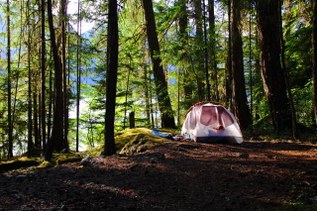
WTA Pro Tip: This is an extremely popular area for camping. On a sunny weekend, start early to allow plenty of time to find a site. Designated as a Natural Resources Conservation Area, Gothic Basin is an extremely fragile ecosystem. Be sure that you're camping on an established site or sturdy surface, like rock or dirt, and avoid camping in meadows or grasses, as this can damage the landscape. Campfires are not allowed in Gothic Basin. Leave no trace by packing out all trash. You’ll also want a bear can, as there are no trees in Gothic Basin suitable for a bear line.

 Trailhead