Trails for everyone, forever

Home Go Hiking Hiking Guide Friday Harbor Biological Laboratories Preserve

Friday Harbor Biological Laboratories Preserve

Puget Sound and Islands > San Juan Islands
48.5457, -123.0142 Map & Directions
Length
4.0 miles, roundtrip
Elevation Gain
440 feet
Highest Point
100 feet
Calculated Difficulty About Calculated Difficulty
Easy/Moderate
A lovely view of the water from the coastal area at the preserve. Photo by Austin Smith. Full-size image
  • Coast
  • Wildlife

Parking Pass/Entry Fee

None
Saved to My Backpack

Two hikes exist here: One, an old road through the woods; and the other, winding along narrow tread on grassy hillsides and exposed bedrock alongside the Puget Sound. Connecting these two makes a great loop. Continue reading

Rating
0.00 out of 5

(0 votes) Log in to rate

Hiking Friday Harbor Biological Laboratories Preserve

This land, officially known as the Friday Harbor Laboratory Preserve, once a military base, is now a research facility operated by the University of Washington. Please respect their request that all trail users register at the main office, and do not enter any other buildings.

Treat the main office as the trailhead even though you will walk a paved road for about 0.25 mile. A map from the office will show you how to thread through the campus buildings to the actual trail. The Fire Trail is an old double-track road running very level through a recovering forest. There are many enormous firs and a few big cedars. This level trail might be smooth enough for some wheelchair users. This northbound trail ultimately ends at Point Caution Drive. If you’re up for more of an adventure, watch for a side trail which descends to the east and the water, at approximately 1.5 miles from the trailhead. This is also a perfectly good turnaround point for those looking for an easier ramble. Other side trails are passed before this, though this one makes for the longest loop.

Descend this trail about 80 vertical feet to the water’s edge. Depending on tide levels, you may walk the beach southward to Point Caution or walk an inland trail a short ways back.

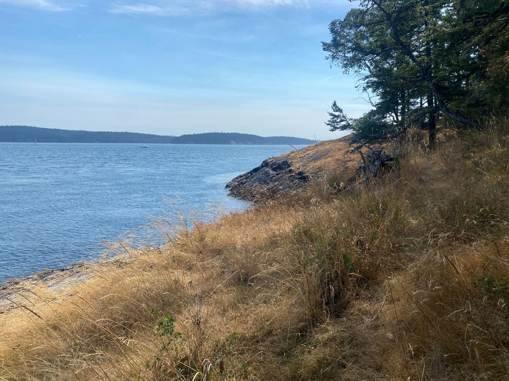
For roughly the next 2 miles, this seaside trail will bob and weave through grassy hills, glacially-scoured bedrock and alongside the ocean. Watch your step, as the tread can be very narrow in places with sharp drop-offs to the rocks below. On a sunny day ,the ocean, sky and islands are just magically blue and green beyond belief. On a rough winter’s day, the surf might give you a run for your money on this trail.

Windswept firs and madronas wrap their lusty arms around everything in sight. Mosses and lichens encrust and entomb the underlying bedrock. Under the waves to your left can be glimpsed eel grasses, kelp and many other intertidal inhabitants. Though the San Juans and the Pacific Northwest are renowned for their wetness, this side of the island is in a rain shadow, making for a very dry climate that you might not expect. Spring and early summer are a remarkable time for unique flora. 

The trail can be difficult to follow in a few spots, though by generally paralleling the shore edge, you should run into it again. Two or three side trails head inland and back to the Fire Trail, giving the option to return back to easier terrain. Staying along the water’s edge, the trail will loop you back to the original trail at 3.2 miles. Turn left to return to the trailhead.

Toilet Information

  • Toilet at trailhead
  • Accessible toilet

More information about toilets

Wheelchair Accessibility

The beginning of this trail is an old double-track road. It is generally level and hard-packed dirt. This could be suitable for a more adventurous wheelchair user. The section described as "along the water" is most definitely not suitable. 

Hike Description Written by
Austin Smith, WTA Correspondent

Friday Harbor Biological Laboratories Preserve

Map & Directions

Trailhead
Co-ordinates: 48.5457, -123.0142 Open in Google Maps

Before You Go

See weather forecast

Parking Pass/Entry Fee

None

WTA Pro Tip: Save a copy of our directions before you leave! App-based driving directions aren't always accurate and data connections may be unreliable as you drive to the trailhead.

Getting There

From the Friday Harbor ferry terminal, take Spring St SW (uphill) for 2 blocks. Turn right (NW) on Second St S. Take this 4 blocks and turn right (North) onto Tucker Ave. Stay on Tucker Ave for about 5 blocks, just as Tucker Ave begins to bear left, go straight onto University Rd. In a few hundred yards, you will enter University of Washington property. In another few hundred yards, administrative building will be on your right.

Park here and enter the main building to obtain permission to use the trails. 

More Hike Details

Trailhead

Puget Sound and Islands > San Juan Islands

University of Washington

Guidebooks & Maps

https://fhl.uw.edu/wp-content/uploads/sites/17/2025/03/FHL-Campus_Trail.pdf

You can improve or add to this guidebook entry!

Friday Harbor Biological Laboratories Preserve

1 Trip Report

Hiked here recently?

Submit a trip report!
 
Loading trip reports...
Trip Reports