
This is a large lake hidden just south of Tonga Ridge in the Alpine Lakes Wilderness. Reached by a brushy, boot-beaten fisherman's path, it is less visited than many lakes in the area, but the route is marked on the map, and if you are willing to put up with a bit of inconvenience, this makes a nice day hike or overnight.
Start by taking the Tonga Ridge trail, a worthy hike in itself. The trail climbs up through straggly second-growth before entering the Alpine Lakes Wilderness in a half mile. Follow this up and down trail along the ridge, through wildflower meadows and young forest. There are some nice views of the surrounding peaks through the trees. In two miles, reach the turnoff for Mount Sawyer on your left, marked with a cairn. If you are a fast hiker, you may want to take this scenic detour.
Continue along the main trail toward Sawyer Pass. In three miles, the trail drops down to a flat meadow of heather and young hemlock trees. Follow the main trail, ignoring any side trails. Once you reach the sign for Deception Creek the fun begins! Here there are a maze of trails resembling a chicken's foot. Just to the right of the Deception Creek sign, find the sign forbidding campfires above 4000 feet.
Take the far right trail a short ways, then at a fork, take the left trail. At the following fork, take the right trail. From the first fork, just remember right, left, right. The trail takes you a short way through trees and huckleberry bushes, then heads uphill. You know you are on the right trail when you see a steep, rooty, eroded but obvious trail heading uphill. Note that this will be a mud fest in the rain, for sure.
Climb up to the first set of meadows and enjoy some 'peak-a-boo' views of Glacier Peak through the trees. Climb a bit more, and notice a nice tarn on your left. Walk over and check the mud for tracks to see if you can figure out who lives in these woods. If the mosquitoes are thick, you may want to admire from afar.
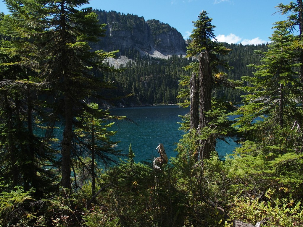
Once through this scenic meadow, climb another steep section of rocky eroded trail and come to a meadow filled with huckleberry bushes. Indeed, you may be sharing the section of the trail with other hikers, both two legged and four. Once through the huckleberries, you have reached the high point and should have some better views of Glacier Peak and more of the Central Cascades and the Skykomish Valley. Now follow more rooty eroded trail as it heads straight ahead and down to the lake. Soon you will see the lake, nestled in a bowl of rock and forest above the Deception Creek valley. The lake is reached in about a half mile from the ridgetop.
Once you reach the lake, follow a brushy trail to the left. This leads to a few nice campsites along the lakeshore with a backcountry toilet. There is one very large diameter tree across the trail that blew down many years ago and is now a nice silver grey. You will need to climb over or go around it.
The trail does not go around the lake, but disappears in brush by the outlet stream. Walk over to the edge of the ridge and get a few glimpses of the next ridge over. Down by the lake, look to the southeast and find Terrace Mountain. Somewhere between you and it are another couple of lakes called Ptarmigan Lakes. If you wish to explore those lakes, you will need routefinding skills. Enjoy the lake, and remember to allow time to pick your way down the steep trail, sometimes harder and slower than going up!
Fisher Lake

-
 Length
- 10.0 miles, roundtrip
-
 Elevation Gain
- 1,580 feet
-
 Highest Point
- 5,171 feet
This is a large lake hidden just south of Tonga Ridge in the Alpine Lakes Wilderness. Reached by a brushy, boot-beaten fisherman's path, it is less visited than many lakes in the area, but the route is marked on the map, and if you are willing to put up with a bit of inconvenience, this makes a nice day hike or overnight.
Continue reading
Hiking Fisher Lake

WTA worked here in 2014, 2013, 2010, 2009 and 2008!
Map & Directions
 Trailhead
Before You Go
Parking Pass/Entry Fee
National Park Pass, Northwest Forest PassWTA Pro Tip: Save a copy of our directions before you leave! App-based driving directions aren't always accurate and data connections may be unreliable as you drive to the trailhead.
Getting There
Take Hwy 2 to Skykomish. Pass the Skykomish Ranger station on the left, just east of town and watch for the Foss River Road (FR 68), and turn right. In 2.6 miles cross under the railroad trestle and go over a small bridge.
In another mile is a Y intersection, take the left on FR 6830, it is hard to see but will be on the right hand side after you turn onto the road.
Follow FR 6830 for 7 miles, then take a right onto road 310 follow to the end and trailhead at 1.3 miles. There is a backcountry toilet behind the trailhead sign on the right.