Trails for everyone, forever

Home Go Hiking Hiking Guide Elsnor Mine

Alert: On Oct. 1 the federal government began a partial shutdown that will impact National Parks, National Wildlife Refuges and U.S. Forest Service lands in Washington. Here's the latest information we have for hikers and campers


Elsnor Mine

Snoqualmie Region > Salmon La Sac/Teanaway
47.4283, -121.0102 Map & Directions
Length
0.95 miles, one-way
Elevation Gain
950 feet
Highest Point
5,860 feet
Calculated Difficulty About Calculated Difficulty
Easy/Moderate
Old mining artifacts alongside the trail. Photo by Tiffany Chou. Full-size image
  • Dogs allowed on leash
  • Mountain views
  • Wildflowers/Meadows

Parking Pass/Entry Fee

Northwest Forest Pass
Saved to My Backpack

This steep connector trail between the Paris Creek and Boulder De Roux trails takes hikers past remnants of old mining activity in the area. Continue reading

Rating
2.33 out of 5

(3 votes) Log in to rate

Hiking Elsnor Mine

The above stats reflect the hike as done from the Boulder De Roux trail to Paris Creek, the uphill direction. There is very little climbing in the opposite direction — it is all downhill. 

The trail starts as a side trail off the Boulder De Roux trail, marked by a sign on a tree. To reach the junction, hike 2.5 miles in from the trailhead on the Boulder De Roux trail; you'll climb about 1,550 feet.

As you start, the trees are relatively thin — enough so that you can peek at the mountains in the distance through them. The trail starts steep, continues steep and ends steep, so get ready for a thigh-burner! 

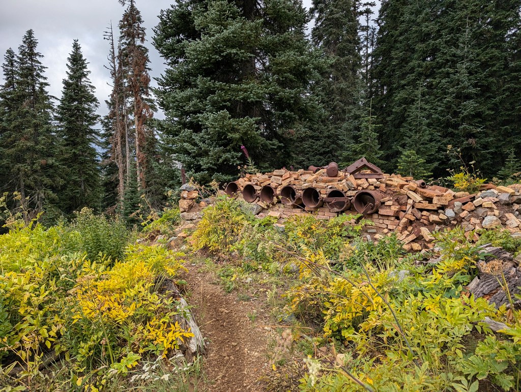
Continue climbing and around 0.3 mile ahead, you'll be able to see some old rusty mining artifacts sitting on the side of the trail. In another quarter mile, the trees will thin further and you'll walk through a meadow to find more substantive mining equipment: old piping with bricks on the side of the trail. Glance behind you to see beautiful views of the mountains. 

You'll reach the junction with the Paris Creek trail in about 0.3 mile. If you're looking to take a break or have lunch around here, hike just a few hundred feet to the west on the Paris Creek trail — there's a great rock overlook here that offers views of the valley. 

If you wish to start from the Paris Creek trail instead, plan for a longer (and steeper!) hike; hike 5.5 miles in from the trailhead, gaining over 3,700 feet, to reach the junction with the Elsnor Mine trail. 

Toilet Information

  • No toilet at trailhead

More information about toilets

Hike Description Written by
Tiffany Chou, WTA Staff

Elsnor Mine

Map & Directions

Trailhead
Co-ordinates: 47.4283, -121.0102 Open in Google Maps

Before You Go

See weather forecast

Parking Pass/Entry Fee

Northwest Forest Pass

WTA Pro Tip: Save a copy of our directions before you leave! App-based driving directions aren't always accurate and data connections may be unreliable as you drive to the trailhead.

Getting There

This trail can be reached via the Paris Creek/Davis Peak trailhead or the Boulder De Roux western trailhead. 

Heading east on I-90, take exit 80 to Bullfrog Rd. Follow Bullfrog Rd for 3 miles and continue straight onto WA-903 N at the traffic circle. Follow Highway 903 N (Salmon La Sac Road) for 16.5 miles and veer right onto Cle Elum Valley Rd/NF-4330. Continue on to the trailhead you're heading to:

PARIS CREEK/DAVIS PEAK TRAILHEAD

Drive on FR 4330 for about 1.6 miles to the Paris Creek/Davis Peak trailhead parking lot on the left. This established trailhead has about a dozen spaces in the parking area.

BOULDER DE ROUX TRAILHEAD

Drive on FR 4330 for about 5.5 miles, then turn right. At the fork ahead, turn right again. You will reach the Boulder De Roux trailhead in about 0.5 mile.

More Hike Details

Trailhead

Snoqualmie Region > Salmon La Sac/Teanaway

Elsnor Mine (#1392.8)

Okanogan-Wenatchee National Forest, Cle Elum Ranger District

You can improve or add to this guidebook entry!

Elsnor Mine

4 Trip Reports

Hiked here recently?

Submit a trip report!
 
Trip Reports