

Breathe in the sea spray on this anything-but-disappointing hike out to the scenic Cape Disappointment Lighthouse, which offers a trail through a coastal forest and glimpses of the powerful Pacific Ocean.
There are two starting points. One is near the entrance to Cape Disappointment State Park. The round trip from this trailhead to the lighthouse is 2.4 miles with a 500-foot elevation gain. The other is at the end of Cape D Road. The round trip from this trailhead to the lighthouse is 1 mile with 150 feet elevation gain.
From entrance trailhead
This is a description of the longer hike. The trailhead is on the left side of the road immediately after the park entrance. The parking lot is straight ahead. There are restrooms near the parking lot. From the parking lot, walk on a paved walkway back to the trailhead. There is a trail map at the trailhead. You immediately start climbing up through a forest. The dirt (and probably muddy) path winds up and down an undulating hill and ends at Lewis & Clark Interpretive Center (LCIC) at 0.6 miles from the trailhead. The entrance fee to this center is $5 as of 2023. Access to the restrooms and the gift shop is free.
Walking on the viewing deck on the right side of LCIC, you will see Cape Disappointment Lighthouse perched on the edge of a cliff ahead and vast expanse of the Pacific Ocean.
Going around LCIC you will see a sign for the continuation of Cape Disappointment Trail. You will hike downhill to a low saddle, where a side trail to the right leads to a beach, ominously named Deadman’s Cove. It requires a bit of a scramble to get down to and should only be accessed by those who are comfortable with the steep terrain. But the reward for your effort is beautiful and unique scenery. There is an islet in the cove that was featured on the cover of Life magazine in July 2005.
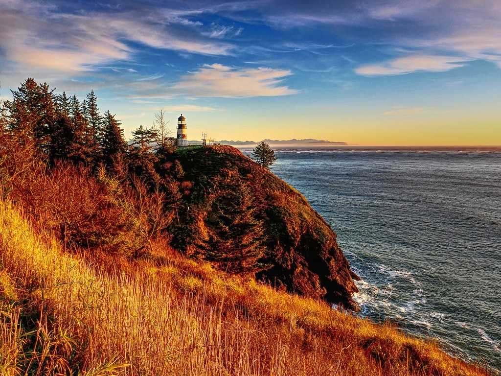
After enjoying the picturesque scenery of Deadman’s Cove, go back up to the main trail. Now a sign directs you to a paved service road to the lighthouse because the last section of the Cape Disappointment trail is shared with the service road from the Coast Guard compound. At the end of the service road is Cape Disappointment Lighthouse, the oldest lighthouse in the Pacific Northwest. The lighthouse is still active, so you may see Coast Guard staff inside or on the road. Leave them to their work as you poke around the lighthouse, The view from the lighthouse is spectacular. Snap a couple of photos and return the way you came.
From Cape D Road trailhead
Head east leaving the parking area on a rolling trail through ferns, salal and evergreens dripping moss (and likely mist). In just a few hundred feet, come to the junction down to Deadman's Cove. From here, continue straight and follow the directions above to make your way to the lighthouse.
WTA Pro Tip: Home to several trails, campsites, cabins for rent and two lighthouses, Cape Disappointment also boasts a visitor center highlighting the journey of the Corps of Discovery — Lewis and Clark’s journey from Missouri to the mouth of the mighty Columbia. If you have time after your hike, make a stop here to round out your visit — it’s located just up the hill from the parking area for the Cape Disappointment Lighthouse.
 Trailhead


