Trails for everyone, forever

Home Go Hiking Hiking Guide Brown's Point Lighthouse Park

Alert: On Oct. 1 the federal government began a partial shutdown that will impact National Parks, National Wildlife Refuges and U.S. Forest Service lands in Washington. Here's the latest information we have for hikers and campers


Brown's Point Lighthouse Park

Puget Sound and Islands > Seattle-Tacoma Area
47.3054, -122.4429 Map & Directions
Length
0.25 miles, roundtrip
Elevation Gain
15 feet
Highest Point
15 feet
Calculated Difficulty About Calculated Difficulty
Easy
Several outbuildings acoompany the lighthouse at Browns Point. Photo by Austin Smith.
  • Coast
  • Dogs allowed on leash
  • Good for kids
  • Wildlife

Parking Pass/Entry Fee

None
Saved to My Backpack

Visit this wheelchair-friendly trail on the north side of Tacoma with views of Commencement Bay, Vashon Island and close up of a lighthouse! Continue reading

Rating
0.00 out of 5

(0 votes) Log in to rate

Hiking Brown's Point Lighthouse Park

Lighthouses have a unique capacity to transport us back to another era. This quaint well-kept park and lighthouse lives up to that ideal. Among the historic buildings an ADA-compliant cement trail winds down to the water's edge as well as a grassy lawn perfect for little ones to run and tumble.
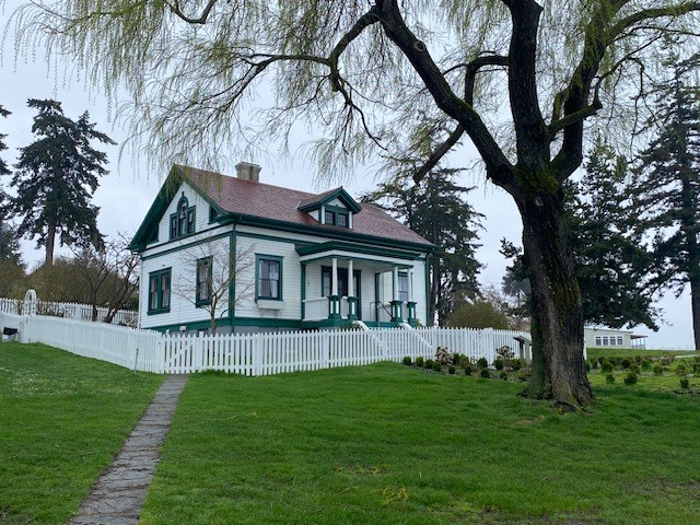
From a small parking area, this ADA trail zig-zags down to the caretaker's house past the remnants of an orchard and flower gardens. This historic building is open for nightly rental so please respect other's experiences. 
Wander down to the water and over to the 1933 art deco lighthouse. Skip a few stones and enjoy the views of Maury Island, Vashon Island, and Port Defiance just across Commencement Bay. 
Imagine the family of two that lived and worked here from 1903 to 1939 tending the orchard, rowing to Tacoma for supplies, and hand cranking the fog bell every ninety minutes when the fog rolled in.
Most of the land in this area is part of the Puyallup Indian Reservation. Be respectful of property boundaries.
Pro Tip: Make a day of it and visit numerous State Parks and wildlife areas around this peninsula

Toilet Information

  • Toilet at trailhead

More information about toilets

WTA worked here in 2021!

Hike Description Written by
Austin Smith, WTA Correspondent

Brown's Point Lighthouse Park

Map & Directions

Trailhead
Co-ordinates: 47.3054, -122.4429 Open in Google Maps

Before You Go

See weather forecast

Parking Pass/Entry Fee

None

WTA Pro Tip: Save a copy of our directions before you leave! App-based driving directions aren't always accurate and data connections may be unreliable as you drive to the trailhead.

Getting There

Drive Highway 509 from Tacoma (Marine View Drive). Drive a couple of miles along the water until 509 turns inland and due north turning into East Side Drive NE. After passing the North 47 Brewing Company on the left watch for a lefthand 'turn' called Hyada Blvd NE. Follow this downhill and around a few bends. As Hyada curves to the left take a sharp right onto Wan-I-Da Ave NE and then an immediate left onto Tulalip St NE. The park and parking lot are straight ahead. 

More Hike Details

Trailhead

Puget Sound and Islands > Seattle-Tacoma Area

Parks Tacoma

You can improve or add to this guidebook entry!

Brown's Point Lighthouse Park

3 Trip Reports

Hiked here recently?

Submit a trip report!
 
Trip Reports