Trails for everyone, forever

Home Go Hiking Hiking Guide Breeden Road - Wall Lake

Breeden Road - Wall Lake

Eastern Washington > Spokane Area/Coeur d'Alene
47.0610, -117.9382 Map & Directions
Length
9.9 miles, roundtrip
Elevation Gain
522 feet
Highest Point
1,726 feet
Calculated Difficulty About Calculated Difficulty
Moderate
Rock Creek rushes past weathered basalt outcrops along Breeden Road. Photo by Mary Hartman. Full-size image
  • Dogs allowed on leash
  • Lakes
  • Rivers
  • Wildflowers/Meadows
  • Wildlife

Parking Pass/Entry Fee

None
Saved to My Backpack

Breeden Road offers expansive views of arid grasslands and basalt outcrops, punctuated with a rushing creek and a small lake. Continue reading

Rating
4.00 out of 5

(6 votes) Log in to rate

Hiking Breeden Road - Wall Lake

The BLM’s Rock Creek Recreation Site has a network of old dirt roads that serve as trails for hikers, mountain bikers and equestrians. This out-and-back hike follows one of those roads over a bridge spanning the rushing rapids of Rock Creek, and on to a small lake nestled between basalt ridges. Waterfowl, songbirds, coyotes and deer are at home here.

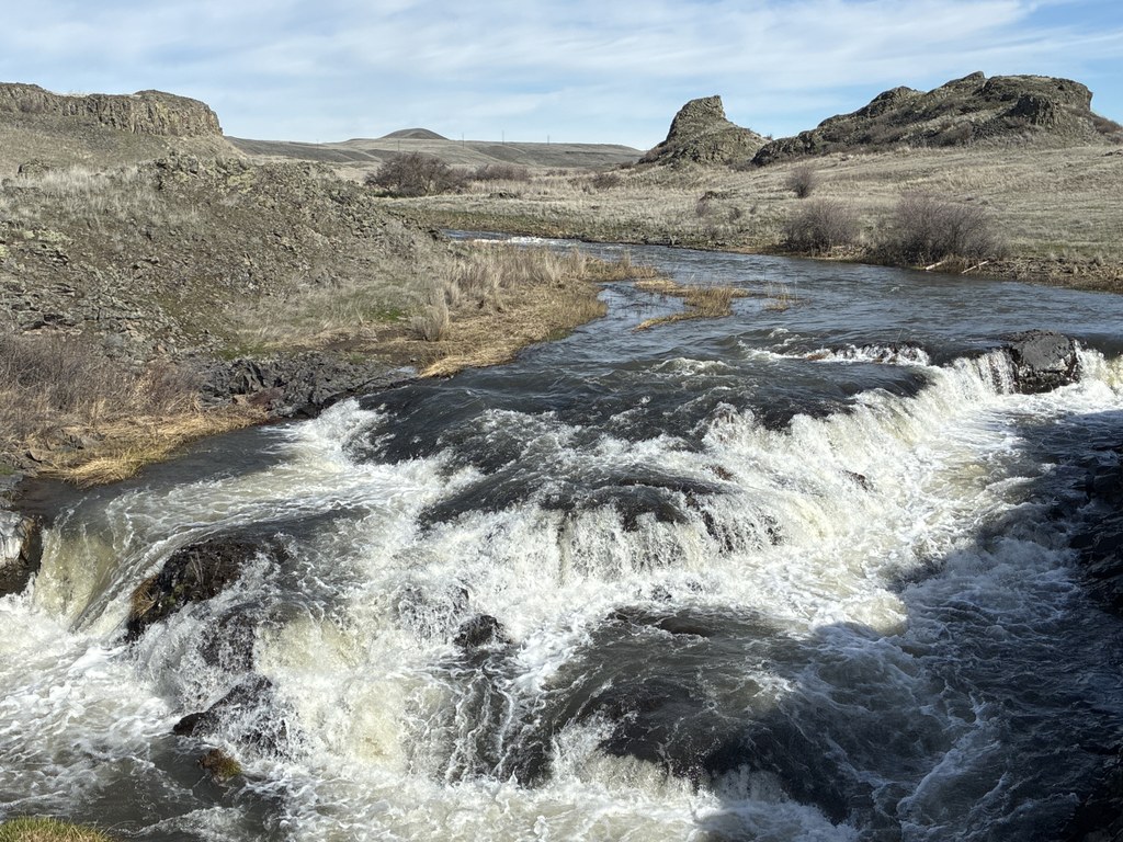
Walk west along Breeden Road, descending gradually past weathered basalt outcrops and grassland. At about 1.6 miles, you’ll hear the rapids of Rock Creek and see a surprisingly robust concrete bridge over the river. Just before you cross the bridge, look for a gate in the fence on the left, and step through to relax by the placid pool below the rapids. This makes a nice spot for a snack and a rest, and a good turnaround point if you want a shorter hike.

For the full hike, cross the bridge and follow the trail along the northern end of the BLM property. You’ll see an old railroad bed on your right that is now part of the Palouse to Cascades State Park Trail. The P2C trail intersects another regional trail, the Columbia Plateau State Park Trail, half a mile to the west.

Breedon Road runs parallel to the P2C Trail for about 2 miles, then passes through an open gate and heads south. This segment of the trail has a few BLM trail markers. At about 0.4 mile from the turn, you’ll reach a fork; stay left. At about 1 mile from the turn, you’ll reach another fork. The trail on the right has a BLM trail marker and goes on to intersect other roads on Escure Ranch. Instead, take the left fork, which leads to the north end of Wall Lake. Enjoy the tranquility for as long as you like, then hike back the way you came.

WTA Pro Tip #1: Despite its potholes and ruts, Breeden Road is open to motor vehicles, so you may see fishermen or hunters depending on the season.

WTA Pro Tip #2: Other hiking opportunities on the Rock Creek Recreation Site can be accessed from the Escure Ranch trailhead, a few miles south of Breeden Road, including the Rock Creek Wildlife Area and Escure Ranch - Towell Falls.

Toilet Information

  • No toilet at trailhead

More information about toilets

Hike Description Written by
Mary Hartman, WTA Correspondent

Breeden Road - Wall Lake

Map & Directions

Trailhead
Co-ordinates: 47.0610, -117.9382 Open in Google Maps

Before You Go

See weather forecast

Parking Pass/Entry Fee

None

WTA Pro Tip: Save a copy of our directions before you leave! App-based driving directions aren't always accurate and data connections may be unreliable as you drive to the trailhead.

Getting There

From Spokane, take I-90 west to the town of Sprague, and take exit 245. Go south on WA-23 for 12.5 miles. Turn right onto Davis Road, a good gravel road. Drive about 7.0 miles, then turn left onto Jordan Knott Road (a fairly good gravel road). Drive about 1.4 miles to Breeden Road (on the right). There isn’t a sign with the road name, but there’s a stop sign on Breeden Road. Park along the side of Jordan Knott Road.

More Hike Details

Trailhead

Eastern Washington > Spokane Area/Coeur d'Alene

Bureau of Land Management

Guidebooks & Maps

Best Desert Hikes: Washington (Bauer & Nelson - Mountaineers Books)

BLM Website: https://www.blm.gov/visit/rock-creek-recreation-site-wa

Washington State Department of Natural Resources (DNR) Rosalia

USGS Revere; USGS Honn Lakes

BLM website map: https://www.blm.gov/sites/blm.gov/files/docs/2021-02/orwa-rock-creek-packer-map.pdf

You can improve or add to this guidebook entry!

Breeden Road - Wall Lake

1 Trip Report

Hiked here recently?

Submit a trip report!
 
Loading trip reports...
Trip Reports