Trails for everyone, forever

Home Go Hiking Hiking Guide Bluff Mountain

Alert: On Oct. 1 the federal government began a partial shutdown that will impact National Parks, National Wildlife Refuges and U.S. Forest Service lands in Washington. Here's the latest information we have for hikers and campers


Bluff Mountain

Southwest Washington > Lewis River Region
45.7423, -122.1910 Map & Directions
Length
12.0 miles, roundtrip
Elevation Gain
890 feet
Highest Point
4,390 feet
Calculated Difficulty About Calculated Difficulty
Moderate/Hard
View from Silver Star looking at the Bluff Mountain trail. Photo by ctam. Full-size image
Saved to My Backpack

Hiking across bare talus slopes, past rocky outcrops and fields of wildflowers while admiring sweeping vistas, you would think you're at 7,000 feet. But the alpine-like setting at this mid-elevation is the result of period of wildfires that swept the area in the early 1900's. Continue reading

  • Dogs allowed on leash
  • Fall foliage
  • Mountain views
  • Ridges/passes
  • Summits
  • Wildflowers/Meadows

Parking Pass/Entry Fee

None, Discover Pass
Rating
3.00 out of 5

(8 votes) Log in to rate

Hiking Bluff Mountain

The Bluff Mountain Trail in the Silver Star Scenic Area is a section of the Chinook Trail System, a work-in-progress 300 mile bi-state loop encircling the Columbia River Gorge. Bluff Mountain is one of many trails that makes up this loop, and is frequently visited by WTA crews for improvement!

The trail starts out from the Bluff Mountain Trailhead in a wide saddle at McKinley Ridge along FR 4100 at about 3475 feet of elevation. The two-track trail continues south along the ridge for another 2.25 miles, passing over a high point of about 3610 feet of elevation before dropping to 3280 feet. It then continues as single-track. The trail then dips into a low, brushy saddle at 3120 feet before climbing the ridge about 1.2 miles southwesterly to a forested saddle between Bluff Mountain and Little Baldy.

The trail then continues on eastward generally following either side of the ridgeline between the Star Creek and the Washougal drainages then coming to the intersection with the Starway Trail at about elevation 3810 feet.

Here, you're about 5 miles from the trailhead. There is typically no water on this leg of the trail and it is more exposed than not, with little or no shade on the talus slope.

From here, continue another 0.8 miles past the junction to an unmarked junction. Turn left and ascend a short trail that joins an old road bed leading to the Silver Star Mountain summit.

Alternately, you can continue past the unmarked junction to an intersection with the Silver Star Trail, where you will turn left (south) onto Trail 190 and take another left about 0.2 miles to reach the summit.

Snow tends to remain on a portion of the trail directly north of the summit and can be challenging to transit when most of the rest of the trail system is clear of snow.

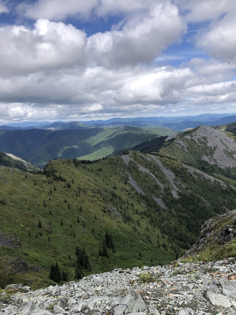
Along the way, the route passes numerous rocky outcrops and open talus slopes where rocky subsoil and repeated fires since the Yacolt Burn of 1902 have limited forest regeneration.

From the top there are the scenic vistas of Portland, the Columbia River and Mount Hood. For the trail maintenance aficionado, you’ll notice some impressive trail building through the talus fields and a few fine rock retaining walls. Lastly, if you forgot your lunch, you’ll be able to feast on huckleberries if the season is right.

About the area

The two-track portion of trail passes through some harvested and re-forested areas, and burned and re-forested area, but is generally open affording views in most directions.

Several of the burned and re-forested areas were mechanically terraced with seedling trees planted in the hinge of the terrace. This method was mostly successful except for a few areas subject to extreme weather near the ridgetops.

WTA worked here in 2024, 2023, 2022, 2014 and 2004!

Hike Description Written by
Multiple authors contributed to this report, WTA Community

Bluff Mountain

Map & Directions

Trailhead
Co-ordinates: 45.7423, -122.1910 Open in Google Maps

Before You Go

See weather forecast

Parking Pass/Entry Fee

None, Discover Pass

WTA Pro Tip: Save a copy of our directions before you leave! App-based driving directions aren't always accurate and data connections may be unreliable as you drive to the trailhead.

Getting There

Note that sections of the gravel road beyond Sunset Campground may have large potholes and graded drain dips. Cars with low-clearance may not be suitable for this drive.

From Vancouver, take Highway 503 north to Battleground. Continue north on 503 (NE Lewisville Hwy) for 5.6 miles. Turn right (east) onto NE 152 Ave./Rock Creek Rd. Continue as the road curves south then east and becomes Lucia Falls Rd. After 8.6 miles, turn right on Sunset Falls Rd. Go 7.3 miles on Sunset Falls Rd to Sunset Campground. Turn right and cross the East Fork Lewis River on FS Road 41. Stay on FS 41 for approximately 9 miles to a large parking area atop McKinley Ridge. This trailhead is the one the hike description begins at.

The intersection can also be accessed from the south starting at the Grouse Vista Trailhead on DNR L-1200 via Grouse Vista Trail, approximately 3.6 miles.

A Discover Pass parking permit is required at the trailhead.

More Hike Details

Trailhead

Southwest Washington > Lewis River Region

Bluff Mountain (#172)

Gifford Pinchot National Forest, Mount Adams Ranger District

Guidebooks & Maps

Greet Trails 396 Lookout Mt.

Green Trails 428 Bridal Veil

Buy the Green Trails Lookout Mountain No. 396 map

Buy the Green Trails Bridal Veil No. 428 map

You can improve or add to this guidebook entry!

Bluff Mountain

19 Trip Reports

Hiked here recently?

Submit a trip report!
 
Loading trip reports...
Trip Reports