Trails for everyone, forever

Home Go Hiking Hiking Guide Beach 1

Alert: On Oct. 1 the federal government began a partial shutdown that will impact National Parks, National Wildlife Refuges and U.S. Forest Service lands in Washington. Here's the latest information we have for hikers and campers


Beach 1

Olympic Peninsula > Pacific Coast
47.5788, -124.3631 Map & Directions
Length
0.2 miles, one-way
Elevation Gain
60 feet
Highest Point
60 feet
Calculated Difficulty About Calculated Difficulty
Easy
Looking out at the ocean from the Beach 1 trail. Photo by Wes Partch. Full-size image
  • Coast
  • Dogs allowed on leash
  • Good for kids

Parking Pass/Entry Fee

National Park Pass
Saved to My Backpack

Beach 1 is a short but scenic trail that ends on a wild beach on the Pacific Ocean. Photogenic spruce burls can be seen on a unique nature loop that adds minimal time. However, access to the beach is typically over a jam of drift logs that require care to cross. Continue reading

Rating
0.00 out of 5

(0 votes) Log in to rate

Hiking Beach 1

Start by finding the signpost and head into the woods beyond the heavily vegetated roadside. Once inside the forest, a kiosk comes into sight, where a small junction marks the Spruce Burl nature loop on the right. It is well worth the extra few minutes it takes to complete the loop.

The striking formations of the burls beckon the hiker into a landscape of unique character. Foggy weather heightens their mystique, creating a solemn atmosphere. Sunsets are especially beautiful here, as the whole forest glows orange and comes alive.

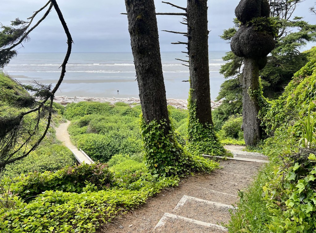
The forest is almost entirely spruce with an exemplary understory of beadruby, salal, skunk cabbage and sword fern. The path is crushed rock and earth, making a pleasant, serpentine line through the veritable garden. The ocean is soon seen framed between parallel trunks of spruce.

Just after the bluff edge, the way joins the main beach trail again, just a stone’s throw away from the kiosk. Now the trail comes to the brink of the bluff and descends through a lush and scenic ravine. Stairs zig-zag down the slope before the trail crosses a small creek on a nice wooden bridge.

Here, the trail becomes a choice of routes that may reward exploring, as the beach is usually blocked by a pile of drift logs that can be hazardous. Caution should be taken to find the path of least resistance to the other side, where the pebbly beach slopes steeply down to the tide flats.

At high tide, the waves crash right into the base of the logs, but at low tide, the beach is transformed into an expansive, sandy wonderland offering miles of glorious walking in either direction. South Beach campground is not far to the south, and Beach 2, followed by Kalaloch, are to the north.

Toilet Information

  • No toilet at trailhead

More information about toilets

Hike Description Written by
Wes Partch, WTA Correspondent

Beach 1

Map & Directions

Trailhead
Co-ordinates: 47.5788, -124.3631 Open in Google Maps

Before You Go

See weather forecast

Parking Pass/Entry Fee

National Park Pass

WTA Pro Tip: Save a copy of our directions before you leave! App-based driving directions aren't always accurate and data connections may be unreliable as you drive to the trailhead.

Getting There

From Queets, WA, drive north on US Highway 101 for 3.5 miles to the marked trailhead. Parking is on both sides of the highway. There is room for about two dozen vehicles.

More Hike Details

Trailhead

Olympic Peninsula > Pacific Coast

Olympic National Park

Guidebooks & Maps

Custom Correct South Olympic Coast

You can improve or add to this guidebook entry!

Beach 1

1 Trip Report

Hiked here recently?

Submit a trip report!
 
Trip Reports