Trails for everyone, forever

Home Go Hiking Hiking Guide Bald Eagle Mountain

Bald Eagle Mountain

Central Cascades > Stevens Pass - West
48.0012, -121.2940 Map & Directions
Length
13.6 miles, one-way
Elevation Gain
3,800 feet
Highest Point
5,800 feet
Calculated Difficulty About Calculated Difficulty
Hard

9.3.25: The trail is closed to Curry Gap until further notice due to the Red Mountain Fire.

Photo by trip reporter Sir-Hikes-A-Lot. Full-size image
  • Mountain views
  • Ridges/passes
  • Rivers
  • Waterfalls
  • Wildflowers/Meadows

Parking Pass/Entry Fee

Northwest Forest Pass
Saved to My Backpack

Enjoy a peaceful river walk followed by nicely graded switchbacks on the way to Bald Eagle Mountain. Views of Monte Cristo and surrounds will be the reward for your efforts. Continue reading

Rating
1.50 out of 5

(4 votes) Log in to rate

Hiking Bald Eagle Mountain

Enjoy a peaceful river walk and nicely graded switchbacks on the way to Bald Eagle Mountain. Views of Monte Cristo and surrounds will be the reward for your efforts.

There is more than one way to access the trail to Bald Eagle Mountain. The following description assumes you are starting from the Quartz Creek trailhead.

The trail follows pretty Quartz Creek, a long, gentle uphill. You will hear the creek but never quite see it. A beautiful waterfall (and creek crossing) at about two miles may require you to remove your boots unless you don't mind wet socks.

At about four miles, reach Curry Gap which consists of a wide, flat meadow with multiple camping opportunities. There are a number of water sources nearby. Fill up on water here if traveling in late summer or during a dry season.

Turn left (uphill) up the switchbacks to Bald Eagle Mountain. Along the way, you will see multiple views of Monte Cristo and surrounds, which comes increasingly into view as you ascend. There are a couple of creeks along the way which may be seasonal.

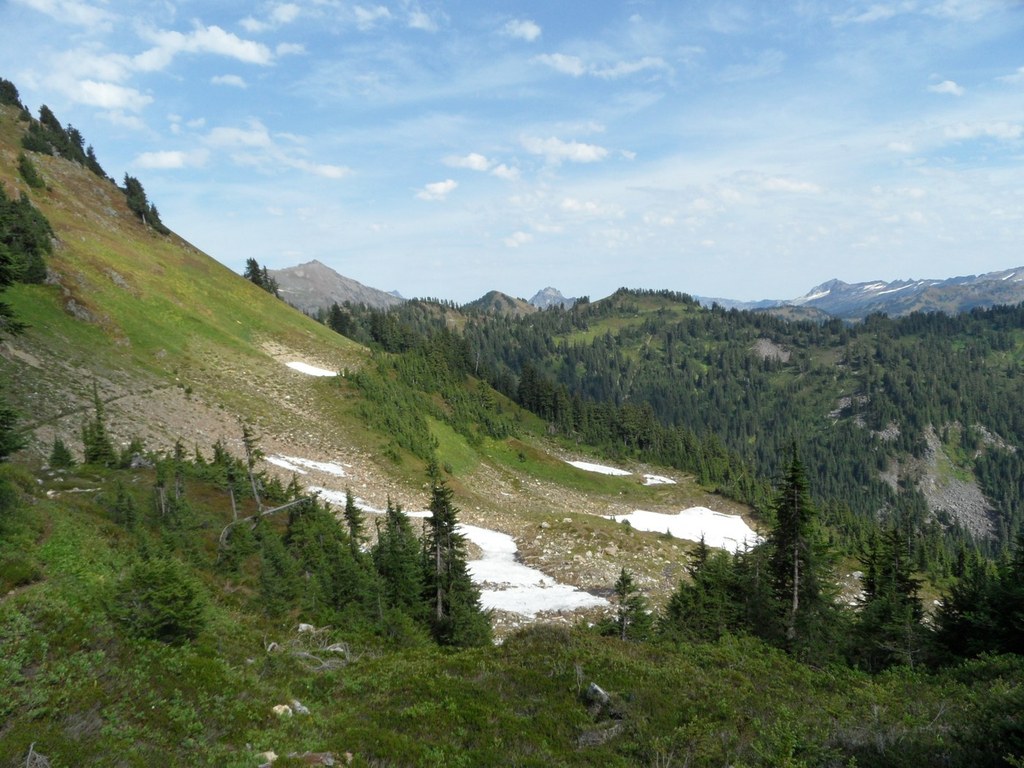
Attain the ridge just shortly before Bald Eagle Mountain. Campsites are scarce and the trail crosses several avalanche shoots. Meander along the ridge before heading down towards a pond; then up again steadily for about 2 miles. An established campsite can be found here, about 9 miles from the trailhead.

From here continue across two large, scenic meadows past June Mountain, to Dishpan Gap and then out the N Fork Skykomish trail for a complete loop.

Toilet Information

  • No toilet at trailhead

More information about toilets

WTA worked here in 2023!

Hike Description Written by
Kate Neville, WTA Staff

Bald Eagle Mountain

Map & Directions

Trailhead
Co-ordinates: 48.0012, -121.2940 Open in Google Maps

Before You Go

9.3.25: The trail is closed to Curry Gap until further notice due to the Red Mountain Fire.

See weather forecast

Parking Pass/Entry Fee

Northwest Forest Pass

WTA Pro Tip: Save a copy of our directions before you leave! App-based driving directions aren't always accurate and data connections may be unreliable as you drive to the trailhead.

Getting There

Coming from the west (Monroe/Seattle)

Drive Highway 2 east towards the town of Index (about 22 miles from Monroe). Turn left at the Sand Bar Tavern, and drive 1.1 miles to a bridge over the North Fork Skykomish River. Continue straight past the bridge, and drive another 13.82 miles on this paved road to a junction with the Beckler River Road.

Take the left fork at this junction, and drive another 2.0 miles on gravel road to a second fork. Take the right fork here, and drive a further, steep 2.5 miles to the trailhead.

Coming from the east (lEavenworth/Wenatchee)

Take Highway 2 west to the Skykomish Ranger District. Drive another 0.6 miles to the Beckler River road, then turn left on to FR 65, more clearly marked as Beckler River Road.

Drive 12.5 miles on this road, passing the Beckler River Campground just after the pavement turns to gravel. After driving 12.5 miles, you arrive at Jack Pass, a 5 way junction. Take the second left. After driving 2.3 miles descending from Jack Pass, arrive at a junction with FR 63. Take a right on FR 63 and continue 4.2 miles to the large shared parking area.


More Hike Details

Trailhead

Central Cascades > Stevens Pass - West

Bald Eagle Mountain (#650)

Mt. Baker-Snoqualmie National Forest, Skykomish Ranger District

Guidebooks & Maps

Best Loop Hikes: Washington (Best Hikes) by Dan Nelson

Green Trails Sloan Peak No. 111

Green Trails Monte Cristo No. 143

Green Trails Benchmark Mtn No. 144

Buy the Green Trails Lake Valhalla No. 111 map

Buy the Green Trails Monte Cristo No. 143 map

Buy the Green Trails Benchmark Mtn No. 144 map

You can improve or add to this guidebook entry!

Bald Eagle Mountain

99 Trip Reports

Hiked here recently?

Submit a trip report!
 
Trip Reports